1 / 4

易淹水地區水患治理計畫 番社口坑排水護岸改善工程

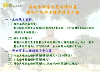
易淹水地區水患治理計畫 番社口坑排水護岸改善工程. 一 、 土地基本資料 ( 1 )徵收土地坐落位置: 彰化縣彰化縣香山段 913 地號內等 4 筆土地,合計面積 0.042303 公頃 ( 詳徵收土地圖說 ) 。 ( 2 )徵收土地屬性: 範圍內以特定農業區農牧用地及鄉村區乙種建築用地」為主,其中 農牧用地面積為 0.027462 公頃,占工程用地範圍之 4.5 %。 二 、 興辦事業之種類及法令依據 ( 1 )依據土地徵收條例第 3 條第 4 款規定。 ( 水利事業 )

kelly-moody
Download Presentation

易淹水地區水患治理計畫 番社口坑排水護岸改善工程

An Image/Link below is provided (as is) to download presentation Download Policy: Content on the Website is provided to you AS IS for your information and personal use and may not be sold / licensed / shared on other websites without getting consent from its author. Content is provided to you AS IS for your information and personal use only. Download presentation by click this link. While downloading, if for some reason you are not able to download a presentation, the publisher may have deleted the file from their server. During download, if you can't get a presentation, the file might be deleted by the publisher.

E N D

Presentation Transcript


  1. 易淹水地區水患治理計畫 番社口坑排水護岸改善工程 一、土地基本資料 (1)徵收土地坐落位置: 彰化縣彰化縣香山段913地號內等4筆土地,合計面積0.042303公頃 (詳徵收土地圖說)。 (2)徵收土地屬性: 範圍內以特定農業區農牧用地及鄉村區乙種建築用地」為主,其中 農牧用地面積為0.027462公頃,占工程用地範圍之4.5%。 二、興辦事業之種類及法令依據 (1)依據土地徵收條例第3條第4款規定。(水利事業) (2)水患治理特別條例第3條規定。 (3)符合土地徵收條例第3條之1及施行細則第2條之1規定。

  2. 番社口坑排水工程規劃圖 工程起點 0K+503 住宅密集區 工程範圍595公尺 彰南路 博愛橋 工程終點 1K+097

  3. 番社口坑排水現況照片 1 2 1 道路、排水兩用 通行不便及危險 已奪2命 2 3 4 3 4 6 6 5 5 7 8 8 7

  4. 番社口坑排水土地使用計畫圖

More Related