Download
1 / 1
10 likes | 233 Views
VESL. OHI2. SYOG. Introduction. BELG. PALM. MAW1. SMRT.

E N D
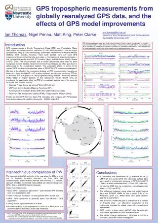
VESL OHI2 SYOG Introduction BELG PALM MAW1 SMRT • GPS measurements of Zenith Tropospheric Delay (ZTD) and Precipitable Water (PW) vapor are widely used as validation or calibration datasets in inter-technique comparisons. They are also increasingly assimilated into Numerical Weather Models (NWMs). Until recently, however, many such studies have not used GPS measurements derived using fully up-to-date or homogeneous analysis strategies – this includes the widely used IGS ZTD product (Byun and Bar-Sever [2008]). Biases in GPS ZTD / PW measurements due to model deficiencies have often not been recognized in such studies. Observed inter-technique biases are often put down to deficiencies in the comparative dataset. The systematic effects of some of the ‘current’ GPS models on the absolute value of GPS ZTD / PW remain uninvestigated. • We look at the effect of the processing strategy on ZTD measurements, focusing on Antarctica. Using the GAMIT 10.35 analysis software, we estimate two-hourly ZTD for 12 Antarctic sites in a global (i.e., using a global tracking network / estimating satellite orbits) ‘base’ or ‘legacy’ solution. In four subsequent ‘model variant’ runs, we investigate the systematic effect on ZTD of cumulatively adding four of the currently accepted ‘best’ models, namely: • Absolute Phase Centre Variations(PCVs) (IGS1402.atx) . • VMF1 wet and hydrostatic Mapping Functions (MF). • A priori Zenith Hydrostatic Delay (ZHD) from observed surface data. • Tidal+non-tidal atmospheric loading (ATML) (Tregoning and Watson [2009]). • Finally, we derive PW from our ‘best’ ZTD estimates, and compare with PW datasets from radiosonde and 2 satellite instruments – MODIS and AIRS. DAV1 AMUN CAS1 MCM4 DUM1 GPS tropospheric measurements from globally reanalyzed GPS data, and the effects of GPS model improvements Ian.thomas@ncl.ac.uk School of Civil Engineering and Geosciences, Newcastle University, UK. Ian Thomas, Nigel Penna, Matt King, Peter Clarke ZTD differences between ‘base’ and model ‘variant’ solution. Plotted is ‘variant’ minus ‘base’, i.e. negative values indicate that the ‘variant’ is drier than the ‘base’. Variants are (i) IGS product (blue line); (ii) ‘base+abs PCVs’ (red line); (iii) ‘base+abs PCVs+VMF1’ (cyan line); (iv) ‘base+abs+VMF1+a priori ZHD’ (magentaline); (v) ‘base+abs+VMF1+a prioriZHD+ATML’ (black line); (v) radiosonde (green line). Inter-technique comparison of PW Conclusions • The two plots to the left and right of the map show, for 2004 and for the 12 Antarctic locations indicated, the final GPS PW measurements, plotted in blue (derived from the final ZTD ‘variant’, using all 4 models mentioned). Also plotted are: radiosonde (green), AIRS (black) and MODIS (pink) datasets. • Features to note include: • Good GPS / radiosonde agreement – sub-millimetre PW at many sites (see scatter plots, left). • Site SYOG is an exception - an unexplained GPS / sonde bias. • AIRS / GPS agreement is generally better than MODIS / GPS agreement. • Strong annual signal observed at all sites. • Greater variability in the tropospheric conditions in West Antarctica and the Antarctic Peninsula, than East Antarctica. • In Antarctica, the introduction of (i) Absolute PCVs (ii) VMF1 MF (iii) a priori ZHD from observed surface data, each result in a systematic decrease in GPS derived ZTD / PW at all sites (combined effect: ~11mm ZTD reduction). • Introducing ATML has, by comparison, a small systematic effect (~1/10th mm ZTD). • The difference between using observed meteorological data and ECMWF NWM for the a prioriZHD is, for Antarctica, small (i.e., NWM offers very good ‘second-best’ for a priori ZHD?) • The reduction ‘closes the gap’ to radiosonde at a number of Antarctic sites – an alternative explanation to the radiosonde ‘dry-bias’ for widely observed inter-technique differences? • AIRS, and to a lesser extent MODIS, offer datasets with reasonable agreement to GPS and radiosonde. • The cause of large radiosonde / GPS bias at SYOG is unknown, and to be further investigated Byun, S., and Y. Bar-Sever (2008), A new type of troposphere zenith path delay product of the international GNSS service, Journal of Geodesy, 83(3), 367-373. Tregoning, P., and C. Watson (2009), Atmospheric effects and spurious signals in GPS analyses, Journal of Geophysical Research, 114, B09403, doi:09410.01029/02009JB006344.