Download
1 / 16

E N D
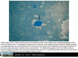
Crater Lake, which is about 6 miles across, is the big blue circle in the middle of this satellite photograph, at the end of the black arrow. A catastrophic eruption from a towering, snow-capped volcano called Mt. Mazama blasted a recognizable layer as far as Nebraska. The remnants of the volcano then collapsed into the hole left behind. As the hole cooled and water collected, Crater Lake formed. This NASA photograph is from the USGS archives. Because logging and other uses continue outside the park but not in, careful examination will show you the outline of the park--three light blue lines are added to help you see it.
http://pubs.usgs.gov/fs/2002/fs092-02/ Here is artist Paul Rockwood’s reconstruction of how the peak might have appeared 6600 years ago, early in the cataclysmic eruption. Notice the glaciers flowing down the sides. The USGS hosts this image courtesy of the Crater Lake Natural History Association .
After the eruption, this USGS photo by W.E. Scott shows the lake in an oblique aerial view (out the window of a plane). On the right, a close-up view (USGS photo by Ed Klimasauskas) shows the “U”-shaped valley of a former glacier,which flowed down from the peak that is no longer there (the outline flying in the sky emphasizes the “U” shape). Later in the semester, we’ll learn why glaciers make “U”s while rivers make “V”s.
Now, we begin some pictures by Prof. Alley. This is Crater Lake from the rim of the crater. That isn’t sky; it's water. Crater Lake probably has the cleanest water of any major lake in the country.
Another shot of trees against the crystal water of Crater Lake. There are no rivers to carry mud into the lake; the rivers all drain away down the sides of the volcano. Rain and snowmelt evaporate from the lake, or leak through the rocks to emerge as springs on the side of the volcano.
Crater Lake gets lots of snow, which melts to fill the lake, and contributes to the fun at the park.
Crater Lake with Wizard Island. After the cataclysmic eruption, additional volcanism began building Wizard Island, which rises about half a mile above the bottom of the lake.
A wide-angle, USGS view of Wizard Island in the lake. Photo by Lyn Topinka.
M W C Water depths at Crater Lake. Everything above the water is gray-white, all below is garishly colored, with red the shallowest water, then orange, yellow, green, blue, and on to purple/violet in the deepest water (to 1949 feet deep). Minor volcanic activity after the main eruption produced features, including Wizard Island (marked with a “W”), which sticks above the water. A later eruption produced lava flows (the Central Platform, “C”) coming from a small volcanic dome (at the end of the arrow). Another volcanic peak in the crater is evident below the water (Merriam Cone, marked “M”). From the USGS at http://craterlake.wr.usgs.gov/bathy_images.html
Dr. Alley's view from Crater Lake, looking along the Cascades Range of similarly explosive volcanoes.
The history of eruptions of the main Cascades volcanoes of Washington, Oregon, and northern California over the last 4000 years, as compiled by the USGS. Each volcano icon indicates an eruption or closely spaced series of many eruptions. The record of written observations is especially good to the right of the red line on the far right, but use of tree-ring dating and other techniques makes all of this highly reliable.
Lassen Peak, in Lassen Volcanic National Park of northern California. Lassen, shown here reflecting a beautiful sunset, erupted about a century ago. Lassen is quite similar to the other Cascades peaks, and remains capable of eruptions.
This rather dates Professor Alley; the 1980 Chevette, seen here at Lassen, was good for 10,000 miles on a seven-week national-parks honeymoon. And we're still happily married.
Bumpass Hell at Lassen Volcanic National Park. This Yellowstone-like, hot-spring-and-sulfur site attests to the volcanic heritage of Lassen.
Mt. Ruapehu, New Zealand. If this peak looks like those of the Cascades that haven't blown up to make a lake, you're getting it. Ruapehu is part of the Pacific Ring of Fire, and has the same basic origin as the Cacades.