Download
1 / 28
290 likes | 556 Views
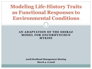
GEO 479/559 Lab GIS For Environmental Modeling. Lab 7 - Hydrologic Modeling: Hydrology Toolset. T.A. – Shiran Zhong. Outline. Basic Concepts in Hydrology Digital Elevation Model Hydrologic Analysis. The Hydrologic Cycle. Atmospheric movement. Ocean subsystem. Land subsystem.

E N D
GEO 479/559 Lab GIS For Environmental Modeling Lab 7 - Hydrologic Modeling: Hydrology Toolset T.A. – Shiran Zhong
Outline Basic Concepts in Hydrology Digital Elevation Model Hydrologic Analysis
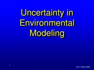
The Hydrologic Cycle Atmospheric movement Ocean subsystem Land subsystem Surface runoff flows
Basic Concepts in Hydrology • Watershed: the network through which water travels to an outlet. • Drainage basin - an area where precipitation travels to a common outlet. • Stream network - the channels which transport water to the outlet. • Outlet -the point at which water flows out of a drainage basin. • Watershed boundary - the boundary between two basins.
Outline Basic Concepts in Hydrology Digital Elevation Model Hydrologic Analysis
Digital Elevation Model (DEM) Sink Peak Two types of anomalies exist in DEMs: sinks and peaks. Sink = an area (set of cells) surrounded by higher elevation values. Peak = a spike in values surrounded by lower elevations. Sinks can cause problems when calculating flow-direction because they result in internal drainage and should be removed prior to analysis.
Slope Aspect The slope aspect of a cell is the direction of the maximum rate of change in elevation. It is common knowledge that water will travel in the direction of the steepest downslope. In hydrological modeling, slope aspect of a cell will determine the direction in which water flows across the cell.
Outline Basic Concepts in Hydrology Digital Elevation Model Hydrologic Analysis
Processing Workflow Any Sinks? Stream Link No Depressionless DEM DEM Yes Fill Sinks Stream Order Calculate Flow Direction Calculate Drainage Basins Flow Accumulation Stream Line
Hydrologic Analysis • Watersheds and stream networks, created from DEMs, are the primary input to many hydrologic models. These models can be used for: • Determining the height, timing, and inundation of a flood • Locating areas contributing pollutants to a stream • Predicting effects of landscape alterations
Customize ArcMap Copy the Lab 7 data folder to your student folder. Launch ArcMap and activate Spatial Analyst (Customize Extensions) The Hydrology toolset is under Spatial Analyst.
Fill Sinks If the DEM contains sinks, water will become ‘trapped’ and cannot flow out. The Fill function modifies the elevation to eliminate these problems by filling the sinks in the DEM.
Add ‘walnut’ grid to ArcMap Select Spatial Analyst Tools Hydrology Fill. Save the output raster.
Flow Direction The flow direction function computes the flow direction for a given grid. The values in the cells of the flow direction grid indicate the direction of steepest descent from that cell.
Calculate Flow Direction 128 32 64 16 1 8 2 4 Add ‘fill_sink’ raster Spatial Analyst Tools Hydrology Flow Direction Save the output raster.
Flow Accumulation Flow accumulation is calculated by counting the number of cells contributing flow to each cell in the grid. Cells which are potentially part of a stream network will have a larger flow accumulation value. Cells near watershed boundaries and places where overland flow dominates will have a lower flow accumulation value.
Calculate Flow Accumulation Add ‘flow_dir’ raster Spatial Analyst Tools Hydrology Flow Accumulation Save the output raster.
Stream Definition The stream definition computes a stream grid which contains a value of "1" for all cells in the input flow accumulation grid with a value greater than the given threshold. All other cells are set to no-data. A rule of thumb for stream threshold -- 1% of the flow accumulation.
Stream Definition Stream Network for 5 cell Threshold Drainage Area Flow Accumulation > 5 Cell Threshold
Calculate Stream Definition • Spatial Analyst ToolsReclass Reclassify • Name the output Stream, and set the threshold to 9 (use the “Delete Entries” button to delete extra “Old values” categories)
Stream Order • To calculate stream order: ArcToolBox Spatial Analyst Tools Hydrology Stream Order • The stream orderfunction assigns a numeric order to segments of a grid representing branches of a linear network. • According to Strahler Hierarchy • All links with no tributaries are assigned an order of 1, and referred to as first order. • When two first order streams intersect, the downslope link is assigned an order of 2. When two second order links intersect, the downslope link is assigned an order of 3, etc. • Only when two links of the same order intersect does the order increase.
Calculate Stream Order • Stream is the input stream raster. Flow_dir is the flow direction raster Select an output file name Use the Strahler method of Stream Ordering.
Stream to Feature • Convert a grid representing a raster linear network to a shapefile in order to: • Calculate length of the stream network. • Perform advanced network analysis. • To convert: Spatial Analyst Hydrology Stream to Feature
Convert Stream to Feature • Stream order is the input stream raster and flow_dir is the flow direction raster Change the output file name.
Stream to Feature Open the stream network shapefile in ArcMap. Note that the Grid_Code corresponds to stream order
Assignment 7 You are the hydrologic engineer for HydroSource, a top-notch firm in the Walnut Creek area. You are in charge of preparing the final report on the Hydrologic Analysis you completed for Walnut Creek. As part of this report, you must include a detailed flow chart visually depicting each of the steps you performed. Unfortunately, the licenses for all of your fancy dancy graphic software programs (Illustrator, InDesign, Photoshop, etc.) have expired (yep, even Paint). The only software you have at your disposal is ArcMap!
Assignment 7 • Save the .mxd (and all datasets if necessary…you will need to export…) to your student folder as well as a .jpeg. • Hand in a hard-copy (one-page) • Q1: Using the workflow chart on Slide 9 as a guide, create a visual step-by-step flow chart of the procedures used today to perform a hydrologic analysis in ArcMap • Include all of the datasets you produced today • You can either insert multiple data frames or insert them as pictures/objects • The Draw Toolbar will come in handy • Include captions with a description of the process at each step • Do not worry about scale bars and north arrows since this is just a visual flow chart.
Q2:Discuss the usage of the hydrology tools that are not covered in the lab.