
Earthquakes
Earthquakes. Science. Earthquakes.
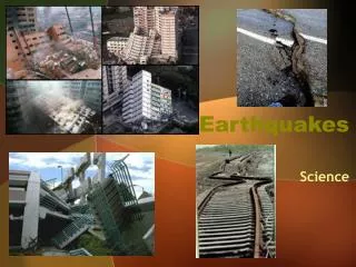

Earthquakes
E N D
Presentation Transcript
Earthquakes Science
Earthquakes An earthquake is what happens when two blocks of the earth suddenly slip past one another. The surface where they slip is called the fault or fault plane. The location below the earth’s surface where the earthquake starts is called the hypocenter, and the location directly above it on the surface of the earth is called the epicenter.
Types of Stress Earthquake – the shaking and trembling that results from the movement of rock beneath Earth’s surface. The stress force called tension pulls on the crust, stretching rock so that it becomes thinner in the middle.
Types of Stress The stress force called compression squeezes rock until it folds or breaks.
Types of Stress Stress that pushes a mass of rock in two opposite directions is called shearing.
Kinds of Faults Tension in Earth’s crust pulls rock apart, causing normal faults. hanging wall – the half of the fault that lies above footwall – the half of the fault that lies below
Kinds of Faults A reverse fault has the same structure as a normal fault, but the blocks move in the opposite direction.
Kinds of Faults In a strike-slip fault, the rocks on either side of the fault slip past each other sideways, with little up and down motion.
Changing Earth’s Surface Over millions of years, the forces of plate movement can change a flat plain into landforms such as anticlines and synclines. anticline – a fold in a rock that bends upward into an arch syncline – a fold in a rock that bends downward to form a bowl
Changing Earth’s Surface Over millions of years, the forces of plate movement can change a flat plain into other landforms such as: folded mountains: commonly form along boundaries where two continents are colliding. fault-block mountains – forms when normal faults uplift a block of rock plateaus – a large area of flat land elevated high above sea level
Types of Seismic Waves Seismic waves carry energy from an earthquake away from the focus, through Earth’s interior, and across the surface. Focus – the point beneath Earth’s surface where rock that is under stress breaks, triggering an Earthquake. Epicenter – the point on the surface directly above the focus
Types of Seismic Waves Seismic waves – vibrations that travel through Earth carrying the energy released during an earthquake. P waves are seismic waves that compress and expand the ground like an accordion. S waves are seismic waves that vibrate from side to side as well as up and down.
Types of Seismic Waves Surface waves move more slowly than P waves and S waves, but they produce the most severe ground movements.
Measuring Earthquakes Earthquakes are measured in 3 different ways. Magnitude – a measurement of earthquake strength based on seismic waves and movement along faults. The Mercalli scale was developed to rate earthquakes according to the amount of damage at a given place. The Richter scale is a rating of the size of seismic waves as measured by a particular type of mechanical seismograph
Measuring Earthquakes The Moment Magnitude scale is a rating system that estimates the total energy released by an earthquake. The Moment Magnitude scale can be used to rate earthquakes of all sizes, near or far.
Locating the Epicenter Geologists use seismic waves to locate an earthquake’s epicenter.
Earthquake Risk Geologists can determine earthquake risk by locating where faults are active and where past earthquakes have occurred.
Tsunami A tsunami is a large ocean wave usually caused by an underwater earthquake or a volcanic explosion. Tsunamis can cause a lot of damage. A tsunami spreads out from an earthquake's epicenter and speeds across the ocean.
Designing Safer Buildings To reduce earthquake damage, new buildings must be made stronger and more flexible.
The Modern Seismograph Seismic waves cause the seismograph’s drum to vibrate. But the suspended weight with the pen attached moves very little. Therefore, the pen stays in place and records the drum’s vibrations.
Instruments That Monitor Faults In trying to predict earthquakes, geologists have developed instruments to measure changes in elevation, tilting of the land surface, and ground movements along faults.
The San Andreas Fault Earthquakes occur often along the San Andreas fault in California.
Resources • http://home.mindspring.com/~cms-stuff/id3.html • http://mail.colonial.net/~hkaiter/earthquakes.html • http://earthquake.usgs.gov/learning/kids/eqscience.php • http://www.weatherwizkids.com/earthquake1.htm • Prentice Hall, Inc Textbook


