Download
1 / 14

E N D
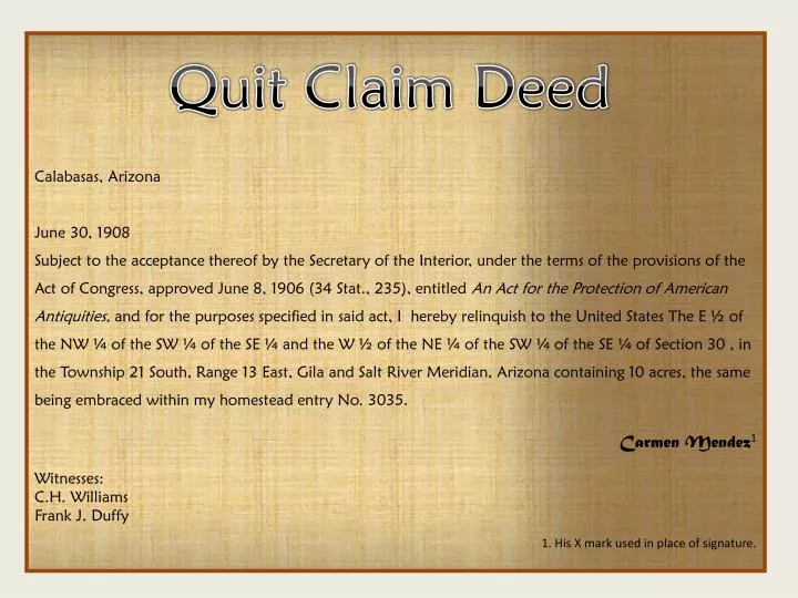
Calabasas, Arizona June 30, 1908 Subject to the acceptance thereof by the Secretary of the Interior, under the terms of the provisions of the Act of Congress, approved June 8, 1906 (34 Stat., 235), entitled An Act for the Protection of American Antiquities, and for the purposes specified in said act, I hereby relinquish to the United States The E ½ of the NW ¼ of the SW ¼ of the SE ¼ and the W ½ of the NE ¼ of the SW ¼ of the SE ¼ of Section 30 , in the Township 21 South, Range 13 East, Gila and Salt River Meridian, Arizona containing 10 acres, the same being embraced within my homestead entry No. 3035. Carmen Mendez1 Witnesses: C.H. Williams Frank J. Duffy 1. His X mark used in place of signature. Quit Claim Deed
Salt and Gila River Meridian Source: http://www.clui.org/section/gila-and-salt-river-meridian
Salt and Gila River Meridian Looking north over the confluence of the Gila and Salt Rivers, the meridian extends to the horizon as 115th Avenue. Source: http://www.clui.org/section/gila-and-salt-river-meridian
Salt and Gila River Meridian Looking east into the Gila River Indian Reservation, the baseline is visible on the ground as it becomes Baseline Road. Downtown Phoenix is in the distance on the left. Source: http://www.clui.org/section/gila-and-salt-river-meridian
Understanding the Section, Township, Range in Quadrangle Location • A township and range combination is a grid box with 36 total sections arranged six by six. Example: The Section, Township and Range here is 15-28-18.
Quadrangle Location Procedure • Label the four Cardinal Directions at the appropriate extremes of your graph paper. • Divide your graph paper horizontally, in thirds with lightly drawn lines. • Make a dark line by drawing over the baseline at the northernmost horizontal third of your graph paper. • Label this horizontal line 20S on its north side.
Quadrangle Location Procedure 5. Divide your graph paper again, this time vertically into quarters, with lightly drawn lines. • Make a dark line by drawing over the edge-line along at the westernmost vertical quarter of the of your graph paper. • Label this vertical line 13E on its eastside.
Quadrangle Location Procedure • Note that points immediately south of 20 S. lie in Township 21 and those immediately east of 12 E. lie in Range 13.
N 12 e 20 s W E 30 S 31
30 Sections 30 and 31 31
Location Procedure Begin with a second piece of graph paper. Create two adjacent 8x8 regions, representing Sections 30 and 31 as Mendez describes in Township 21 South, Range 13 East . Divide Section 30 into four equal parts, drawing a light border around the SE quadrant. Then divide that region in four equal parts again, drawing a light border around the SW quadrant. Then divide that region in four equal parts again, drawing a light border around the NE quadrant. Then divide that region in two equal parts, drawing a light border around the Western half. Fill in that Western portion. 30 31
Location Procedure 8. Keep reference lines for borders of Section 30 and 31, but Erase all lines made except the borders of the western portion you just you just filled. Do not erase that filled portion. Divide Section 30 into four equal parts, drawing a light border around the SE quadrant. Then divide that region in four equal parts again, drawing a light border around the SW quadrant. Then divide that region in four equal parts again, drawing a light border around the NE quadrant. Then divide that region in two equal parts, drawing a light border around the Western half. Fill in that western portion. 30 31
Location Procedure 9. With this step we have to reset our map partially to account for the “and” in the Mendez text. 30 States The E ½ of the NW ¼ of the SW ¼ of the SE ¼ and the W ½ of the NE ¼ of the SW ¼ of the SE ¼ of Section 30 31
Location Procedure • Divide Section 30 into four equal parts, drawing a light border around the SE quadrant. • Then divide that region in four equal parts again, drawing a light border around the SW quadrant. • Then divide that region in four equal parts again, drawing a light border around the NW quadrant. • 13. Then divide that region in two equal parts, drawing a light border around the Eastern half. • 14. Fill in that Eastern portion. 30 31