Download
1 / 44
440 likes | 541 Views
Hydrologic Information System for the Nation. Ilya Zaslavsky Spatial Information Systems Lab San Diego Supercomputer Center UCSD. http://his.cuahsi.org http://hiscentral.cuahsi.org http://hydroseek.net http://river.sdsc.edu/ucsddash http:// wron.net.au/DemosII/Modules/ODMKMLGatway.aspx

E N D
Hydrologic Information System for the Nation Ilya Zaslavsky Spatial Information Systems Lab San Diego Supercomputer Center UCSD http://his.cuahsi.org http://hiscentral.cuahsi.org http://hydroseek.net http://river.sdsc.edu/ucsddash http://wron.net.au/DemosII/Modules/ODMKMLGatway.aspx http://maxim.ucsd.edu/mattsmaps/storet.aspx BOM talk, Melbourne, March 19, 2009
SDSC Spatial Information Systems Lab http://spatial.sdsc.edu/lab/ Research and system development • Services-based spatial information integration infrastructure, CI projects • Mediation services for spatial data, query processing, map assembly services • Long-term spatial data preservation • Spatial data standards and technologies for online GIS (SVG, WMS/WFS) • Support of spatial data projects at SDSC and beyond In Geosciences (GEON, CUAHSI, CBEO,…) services In Neurosciences (BIRN, CCDB, WBC) In regional development (NIEHS SBRP, CRN…) Contact: zaslavsk@sdsc.edu
Outline • CUAHSI HIS Refresher • Recent developments • WaterML, and services • WaterML 1.1 • Towards OGC standards and WaterML 2.0 • HISCentral updates • Ontology management updates • Data cubes and visualization • Several difficult questions and trade-offs
Consortium of Universities for the Advancement of Hydrologic Science, Inc. 122 US Universities as of July 2008 An organization representing more than one hundred United States universities, receives support from the National Science Foundation to develop infrastructure and services for the advancement of hydrologic science and education in the U.S. http://www.cuahsi.org/
What is the CUAHSI HIS? CUAHSI HIS: NSF support through 2012 (GEO), ~10 mil invested Partners: Academic: 11 NSF hydrologic observatories, CEO:P projects, LTER… Government: USGS, EPA, NCDC, NWS, state and local Commercial: Microsoft, ESRI, Kisters International: Australia, UK Standardization: OGC, WMO (Hydrology Domain WG, CHy); adopted by USGS, NCDC An online distributed system to support the sharing of hydrologic data from multiple repositories and databases via standard water data service protocols; software for data publication, discovery, access and integration.
Map for the US Build a common window on water data using web services Observation Stations Ameriflux Towers (NASA & DOE) NOAA Automated Surface Observing System USGS National Water Information System NOAA Climate Reference Network
NWISWeb site output # agency_cd Agency Code # site_no USGS station number # dv_dt date of daily mean streamflow # dv_va daily mean streamflow value, in cubic-feet per-second # dv_cd daily mean streamflow value qualification code # # Sites in this file include: # USGS 02087500 NEUSE RIVER NEAR CLAYTON, NC # agency_cd site_no dv_dt dv_va dv_cd USGS 02087500 2003-09-01 1190 USGS 02087500 2003-09-02 649 USGS 02087500 2003-09-03 525 USGS 02087500 2003-09-04 486 USGS 02087500 2003-09-05 733 USGS 02087500 2003-09-06 585 USGS 02087500 2003-09-07 485 USGS 02087500 2003-09-08 463 USGS 02087500 2003-09-09 673 USGS 02087500 2003-09-10 517 USGS 02087500 2003-09-11 454 Time series of streamflow at a gaging station
CUAHSI Observations Data Model http://his.cuahsi.org/odmdatabases.html
Set of query functions Returns data in WaterML Water Data Services NWIS Daily Values (discharge), NWIS Ground Water, NWIS Unit Values (real time), NWIS Instantaneous Irregular Data, EPA STORET, NCDC ASOS, DAYMET, MODIS, NAM12K, USGS SNOTEL, ODM (multiple sites)
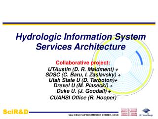
Hydrologic Information System Service Oriented Architecture HIS Lite Servers Test bed HIS Servers Central HIS servers External data providers Global search (Hydroseek) Deployment to test beds Customizable web interface (DASH) Other popular online clients HTML - XML Desktop clients Data publishing HIS CentralRegistry & Harvester Water Data Web Services, WaterML WSDL - SOAP Ontology ETL services Controlled vocabularies Metadatacatalogs ArcGIS WSDL and ODM registration Matlab IDL, R Ontology tagging (Hydrotagger) MapWindow ODM DataLoader Excel Streaming Data Loading Programming (Fortran, C, VB) ODMTools Modeling (OpenMI) Server config tools
6 5 4 2 3 1 TEST BED HIS SERVER ORGANIZATION STEPS FOR REGISTERING OBSERVATION DATA DASH Web Application Web Configuration file Stores information about registered networks MXD Stores information about layers Layer info,symbology, etc. WSDLs, web service URLs Connectionstrings Spatial store WOF services NWIS-IID points NWIS-IID WS USGS SQL Server NWIS-DV points NWIS-DV WS NWIS-IID NCDC ASOS points ASOS WS NWIS-DV STORET points STORET WS ASOS EPA TCEQ points TCEQ WS STORET BearRiver points BearRiver WS TCEQ TCEQ . . . . . . More WS fromODM-WS template More synced layers BearRiver My new points My new WS . . . More databases Background layers(can be in the same or separate spatial store) Geodatabase or collection of shapefilesor both Web services from a common template My new ODM ODMs and catalogs. All instances exposed as ODM (i.e. have standard ODM tables or views: Sites, Variables, SeriesCatalog, etc.) ODMDataLoader
Hydroseekhttp://www.hydroseek.net Supports search by location and type of data across multiple observation networks including NWIS, Storet, and academic data
Requirements for a community data exchange protocol Ability to accommodate structurally and syntactically different data sources Conformance with accepted semantics of hydrologic data discovery and retrieval Following common use cases, and alignment with the CUAHSI ODM Ability to express and re-use common structural components of the information model Relative simplicity and transparency, to ease community adoption Ability to integrate with other datasets within and across research domains Fidelity and reliability in relaying core information on hydrologic observations A governance structure, where site and variable identifiers, vocabulary and ontology conventions, structural definitions for data interchange, and other components of the exchange protocol are managed across observation networks Reliance on implementation best practices, protocol implementation in the context of an operational distributed information system for hydrologic data Ability to reliably and efficiently relay hydrologic information when metadata and data are at physically different locations
WaterML Evolution • WaterML 1.0: OGC Discussion Paper, 2007 • WaterML 1.1: mid-2008 • To reflect changes in ODM 1.1 (expose additional fields) • To remove enumerations used to implement controlled vocabularies (e.g. for ValueType, DataType, GeneralCategory) • Consistency (e.g. remove reliance on IDs; units • WaterML 2.0: harmonizing WaterML 1.1 with O&M, to be accessed via SOS and/or WFS
location variable values TimeSeries
WaterML 1.1: Extensibility • Additional elements: siteInfo/siteProperty; variable/variableProperty;series/seriesProperty; values/valuesProperty
WaterML 1.1: other • Space-delimited qualifiers • Added SiteType as used by EPA and USGS • Added Speciation to VariableInfoType • Suggested lists of terms instead of enforced enumerations (doesn’t throw an error on unknown terms) • Multiple Values (change cardinality to 1+) • A USGS site can have multiple streams of the same variable parameter from different instruments, e.g. Variable: NWISDV:00065 or NWISDV:00065/statistic=00003 or NWISDV:00065/ValueType=Average • Changes in method names (for consistency)
Toward WaterML 2.0 • Use Simple GML • Utilize XML namespaces(though need a wrapper) • Extensible to additional use cases • Prototype implementations demonstrating the use cases • Deliver information over modified Water Data Services, or WFS/WCS/SOS • Understand the implications of the change to the user community • Best Practices: Units of Measures
Variable/Phenomenon Semantics • Nitrogen • e.g. NWIS parameter # 625 is labeled ‘ammonia + organic nitrogen‘, Kjeldahl method is used for determination but not mentioned in parameter description. In STORET this parameter is referred to as Kjeldahl Nitrogen. • Turbidity : 5 different units And: Dissloved oxygen
Two mechanisms • Controlled vocabularies • Ontologies, and ontology tagging • OWL • http://svn.sdsc.edu/repo/WATER/CUAHSI/OntologyOwl/StarTree_Current/ontology • Tabular • https://svn.sdsc.edu/repo/WATER/CUAHSI/OntologyOwl/TabularLayout/OntologyTable_2_4_2009.csv • Startree • Wiki + Startree (e.g. http://water.sdsc.edu:7788/demo/NIF/index.html What are the use cases…
US Map of USGS Observations Alaska Puerto Rico Hawaii Antarctica
Different types of nutrients by decade: Available Data Total
Some physical properties by decade: Available Data Total
WhichML Must be considered in the context of specific information they were designed to communicate, and implementation use cases they were intended to support • USGS HydroML (mirrors NWIS) • EPA’s WQX (to submit “activity” data; activity-method-sample-result) • IWDTF (GML simple features) • GRDC (ISO/TC211 compliant) • O&M-compliant • … no simple schema will be able to fully communicate the details of a rich variety of information used in hydrologic modeling
Series vs Observations • a series: data values associated with a unique site, variable, method, source, and quality control level combination, collected between a start and end date and time. • Key construct in WaterML; most metadata associated with it • Advantages: • better alignment with common usage scenarios; • easier interpretation and compactness, without excessive references • support of efficient implementation of the entire discovery phase over a SeriesCatalog. • 1.75 million stations; 134 million observation series, • efficient formulation of “data carts” as collections of series. • Most recent: http://river.sdsc.edu/wiki/HIS%20Desktop%20Database.ashx
General vs rigid schema • Initial goal: a fairly small, rigid and efficient hydrologic data message format • easy to completely implement, validate, parse and interpret • Used as infrastructure backbone • Has been quickly adopted • Though support for limited use cases • Second phase: • Expanded use cases, less rigidly defined schema • a more general format
Summary • Generic method for managing and publishing observational data • Supports many types of point observational data • Overcomes syntactic and semantic heterogeneity using a standard data model and controlled vocabularies • Supports a national network of observatory test beds but can grow! • WaterML is a standard language for consistently communicating water observations data from academic and government sources using web services – develops towards OGC standards • National Water Metadata Catalog is the most comprehensive index of the nation’s water observations presently existing Join the Water Data Federation!
Coming soon… All Hands Meeting of CUAHSI HIS at SDSC; April 6-7 2009 HIS expansion: SE Asia, SBRP program; water research centers Open Geospatial Consortium: considers Hydrology Domain Working Group (end of March): focus on WaterML 2.0 Collaboration with World Meteorological Organization (joint charter between WMO’s CHy and OGC’s Hydrology DWG) Automated facilities for uploading/hosting observations data Integration with real-time (via DataTurbine), with hydrologic models (via OpenMI, CSDMS), animations, spatio-temporal interpolation Desktop HIS (this year)