Download
1 / 41
410 likes | 824 Views
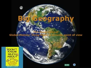
Big Geography The Geography of Global History. We need a mental picture of the whole world, not just certain parts of it. This is “big geography.”. Africa. U S A. South America. Hi. I’m Mundo. Did you know that how we “see” the world depends on how we project the world?.

E N D
Big Geography The Geography of Global History
We need a mental picture of the whole world, not just certain parts of it. This is “big geography.”
Africa U S A. South America
Hi. I’m Mundo. Did you know that how we “see” the world depends on how we project the world?
The Earth is a sphere. Therefore, it cannot be projected on a flat map without distortion. The question is, which kind of distortion?
On a Mercator projection, invented by Gerardus Mercator in 1569, any straight line is a line of constant compass bearing. This enables a navigator to plot a straight-line course.
Despite the values of the Mercator Projection, it distorts the size and shape of land areas. Fact: South America is 8 times as large as Greenland. Fact: Africa is 14 times as large as Greenland. The Peters Projection is an “equal area” map. It represents areas accurately, but it seriously distorts shapes. Compare the size of Europe to Africa on the two maps. Compare the size of the former USSR to China on the two maps.
Human beings inhabit the biosphere. The biosphere is made up of three layers. • The lithosphere: The solid earth, or outer crust of rock, sand, and soil. • The hydrosphere: The watery realm. About 97 percent of it is the oceans. • The atmosphere: The thin layer of gasses, mainly nitrogen and oxygen.
The lithosphere is in constant, though slow motion. The surface of the earth and the location of its land masses have therefore had a continuously changing history.
The scene of history is continuously moving land masses.Notice in the left column the names of distinct land masses that no longer exist.The red dot represents the location of the Grand Canyon. India 550 Million Years Ago 130 Million Years Ago Pangaea South America 220 Million Years Ago 65 Million Years Ago Laurasia Gondwanaland Today 190 Million Years Ago
70.9 % of the surface of the earth is water. Human beings, however, are a land-dwelling species. We call the biggest land areas continents.
How many continents are there? Nine? One? Seven? Five? Four?
But what IS a continent? The conventional map of seven continents
Conventional definition of a continentA large mass of land surrounded, or nearly surrounded, by water. If that is the conventional definition, why are Europe and Asia separate continents?
Since the nineteenth century, most scholars have accepted the Ural Mountains as part of the dividing Line between “Europe” and “Asia” as continents. The Urals as a border between continents? They are not that impressive.
Ural Mts. EUROPE ASIA Another part of the dividing line: Bosporus and Dardanelles (Straits)
Istanbul Bosporus Dardanelles
What significance have the Bosporus and Dardanelles had as a line dividing peoples from one another in history? Almost none!
The Ottoman Turkish Empire about 1550. Its territory cut straight across the Bosporus and Dardanelles.
Here’s a highway bridge across the Bosporus. Today, you can drive from “Asia” to “Europe” in a few minutes.
So, why is Europe a continent? European scholars of the nineteenth century decided that it should be one. One of the benefits of having power in the world is that you get to name things!
The dividing line between “Europe” and “Asia” is not something that is “natural.” That is, it does not exist as a fact of the natural world. Many geographers have therefore been willing to unite the two regions as a single continent called “Eurasia.”
Asia + Europe = Eurasia E U R A S I A
But is Africa separated from Eurasia by a wide ocean? No! Why not think of Eurasia and Africa together as a single “supercontinent?” Let’s call it “Afroeurasia.”
Africa + Asia + Europe = Afroeurasia A F R O E U R A S I A
Think of Afroeurasia as having some seas “inside” it. Black Sea Caspian Sea Mediterranean Sea Persian Gulf Red Sea You figure out which is which?
One of the big geographical features of Afroeurasia is the Great Arid Zone. This is the belt of arid or semi-arid land that extends nearly across Afroeurasia. Great Arid Zone
Scenes in the Great Arid Zone of Afroeurasia Extreme dryness Ahaggar Mts., Sahara Desert Semi-aridity Grassy steppes of Mongolia
Historically, peoples who herd animals as a way of life have inhabited many parts of the Great Arid Zone. These herders are pastoral nomads, that is, they move with their herds or flocks from pasture to pasture. Herders in Mongolia
A major theme in world history has been the dynamic relations between pastoral nomadic peoples of the Great Arid Zone… …and peoples who have been farmers or city-dwellers.
Nomadic peoples of the Great Arid Zone both traded and clashed with farming and city-dwelling peoples who lived adjacent to the Great Arid Zone. One of the greatest clashes was the attacks of Mongol nomads on cities of Eurasia in the 13th century.
The Eleven Seas of Afroeurasia They made it easier for people to communicate by water across Afroeurasia. Name these seas! 1 2 3 11 4 10 6 5 7 8 9
Before modern times, merchants relayed goods from one link in the “chain of seas” to another. That is, a single merchant did not make the trip from one end of the chain to the other, though it was theoretically possible.
Another feature of big geography isthe earth’s great mountain chains Mountains have been barriers to human communication. But passes across them have also served as “valves” of communication.
The major winds and currents of the oceansUntil the coming of steamships in the 19th century, sailors had to know winds and currents to have confidence that they could sail from one place to another in an approximate amount of time. These winds and currents follow large global patterns. It was a matter of discovering what those patterns were. winter summer Indian Ocean Monsoon Winds
The wind cycle in the North Atlantic helped Christopher Columbus sail both ways across the ocean. WIND WIND
So, how many continents? • Afroeurasia • Australia • Americas • Antarctica • Afroeurasia • Australia • North America • South America • Antarctica But is it possible to think of North and South America as ONE continent?
Are the Americas one continent or two? Try to think of the Gulf of Mexico and the Caribbean Sea as bodies of water “inside” the Americas. Gulf of Mexico Caribbean Sea
Finally, let’s not forget great rivers. They have served as channels of communication between seas and deep interior lands. Danube Yellow (Huang) Indus Ganges Columbia Yangze Niger Mekong Mississippi Nile Tigris-Euphrates Congo Amazon Darling-Murray