Download
1 / 23
270 likes | 584 Views
Review soil properties Factors influencing spectral signatures of soils Identification of landforms Reminder: Annotated Bibliography assignments due today on AsUlearn ! Let me know if you have any questions in the meantime. Remote Sensing of Soils and Landforms. Standard Soil Profile

E N D
Review soil properties Factors influencing spectral signatures of soils Identification of landforms Reminder: Annotated Bibliography assignments due today on AsUlearn! Let me know if you have any questions in the meantime. Remote Sensing of Soils and Landforms
Standard Soil Profile (U.S. Department of Agriculture) Jensen, 2000
Soil Particle Size Scales Jensen, 2000
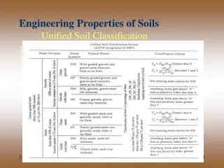
Soil Texture Triangle Clay (%) Silt (%) Sand (%) Jensen, 2000
Total Upwelling Radiance (Lt) Recorded by a Remote Sensing System over Exposed Soil is a Function of Electromagnetic Energy from Several Sources Jensen, 2000
What are the factors that influence the spectral reflectance of soils?
Spectral Reflectance Characteristics of Soils Are a Function of Several Important Characteristics • soil texture (percentage of sand, silt, and clay), • soil moisture content (e.g. dry, moist, saturated), • organic matter content, • iron-oxide content, and • surface roughness. Jensen, 2000
In situ Spectroradiometer Reflectance Curves for Dry Silt and Sand Soils Percent Reflectance Jensen, 2000 Wavelength (mm)
Reflectance from Dry versus Wet Soils Radiant energy may be reflected from the surface of the dry soil, or it penetrates into the soil particles, where it may be absorbed or scattered. Total reflectance from the dry soil is a function of specular reflectance and the internal volume reflectance. As soil moisture increases, each soil particle may be encapsulated with a thin membrane of capillary water. The interstitial spaces may also fill with water. The greater the amount of water in the soil, the greater the absorption of incident energy and the lower the soil reflectance. Jensen, 2000
Reflectance from Moist Sand and Clay Soils Sand Higher moisture content in (a) sandy soil, and (b) clayey soil results in decreased reflectance throughout the visible and near-infrared region, especially in the water-absorption bands at 1.4, 1.9, and 2.7 mm. Percent Reflectance Clay Percent Reflectance Jensen, 2000
Organic Matter in a Sandy Soil Generally, the greater the amount of organic content in a soil, the greater the absorption of incident energy and the lower the spectral reflectance Jensen, 2000
Iron Oxide in a Sandy Loam Soil Iron oxide in a sandy loam soil causes an increase in reflectance in the red portion of the spectrum (0.6 - 0.7 mm) and a decrease in in near-infrared (0.85 - 0.90 mm) reflectance Jensen, 2000
Drainage Patterns: Dendritic, Trellis, and Rectangular Jensen, 2000
Drainage Patterns: Parallel, Radial and Centripetal, Annular Jensen, 2000
Drainage Patterns: Dichotomic, Braided, and Anastomotic Jensen, 2000
Landsat Thematic Mapper Image of the Intersection of the San Andreas and Garlock Faults Garlock Fault San Andreas Fault Landsat band 4 image Shaded relief map derived from a digital elevation model
Kilauea caldera Pu’u O’o crater Kilaueacaldera Pu’u O’o crater Composite Space Shuttle SIR-C/X-SAR image (bands C, X, L) of Kilauea Hawaii volcano on April 12, 1994 SIR-C image overlaid on a digital elevation model. Overland flow of lava on the shield volcano is evident. Jensen, 2000
Kilauea Pu’u O’o crater Aerial photography of the overland flow of lava on the Kilauea Hawaii volcano Jensen, 2000
Three-dimensional Perspective View of Isla Isabela of the Galapagos Islands Obtained by the Space Shuttle SIR-C/X-SAR (draped over a digital elevation model) a’a lava flow pa’hoehoe lava Extruded lava dome (shield) volcano Jensen, 2000
Mount St. Helens erupting May 18, 1980 (U.S.G.S.) USGS High Altitude Photography Stereopair of Composite Cone Mount St. Helens in Washington August 6, 1981 Jensen, 2000
Panchromatic Stereopair of a Synclinal Valley in the Appalachians near Tyrone, PA Canoe Mountain Strike Jensen, 2000 Brush Mountain The ridge lines of Brush Mountain on the west and Canoe Mountain on the east are composed of more resistant sandstone while the less resistant, soluble limestone sedimentary rock has been eroded. The inter-bedding of the sandstone and limestone results in hogback ridges at the periphery of the syncline with a trellis drainage pattern.
Landsat Thematic Mapper Imagery of the Mississippi River Bands 4,3,2 (RGB) January 13, 1983 natural levee point bar forest man-made levee oxbow lake meander scars Jensen, 2000
Mississippi River Delta, U.S. Niger River Delta, Africa Deltas bird’s foot delta lobate delta Nile River Delta, Egypt Irrawaddy River Delta, Burmah lobate delta crenulate delta Jensen, 2000