Download
1 / 68
680 likes | 823 Views
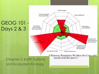
Geog 3 Tectonics. Full recap – everything in one handy PowerPoint....enjoy Mr V. What do we need to know?. What case studies you we need?. Structure of the Earth. Earth’s interior divided into its four concentric spheres: the crust , the mantle , the outer core and inner core . .

E N D
Geog 3 Tectonics Full recap – everything in one handy PowerPoint....enjoy Mr V
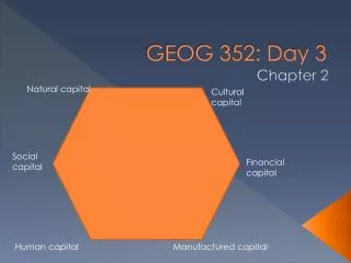
Structure of the Earth • Earth’s interior divided into its four concentric spheres: the crust, the mantle, the outer core and inner core.
Key terms Defined Crust • Earth’s crust made up of 3 kind of rock: • Igneous • Sedimentary • Metamorphic • 2 types of crust: • Oceanic is dense and basaltic in name. approx 10km thick. • Continental crust less dense up to 70 km thick.
Lithosphere = Rigid ‘plate’ comprising of the crust and upper mantle. • Asthenoshere = Plastic like in upper layer. Allows the plate to move • Mantle = Dense solid layer. Rich in iron and magnesium. Beneath this is the semi-molten outer core and a solid inner core.
How do we know this structure is true?’ • Answer = we use measurements from earthquakes • Both P and S waves travel through the interior of the earth and are recorded on seismographs. P and S waves travel at different velocities according to the density of the material which they travel. • E.g S waves are not able to travel through liquids. Using this data scientists can build a picture of the thickness and composition of the layers.
Continental Drift Theory • Earthquakes, volcanoes and fold mountains all occur in similar areas. They occur in long narrow bands thousands of miles long but only hundreds of kms wide. These narrow bands are the Plate Boundaries. • Over millions of years the continents have drifted apart from an original supercontinent called Pangea. • The idea of Continental Drift was first put forward by Alfred Wegener in 1912. His evidence came from things like: • The similarity in the shape of the coastlines of S. America and Africa • Similar glacial deposits from 290 million years ago are found in S. America, Antarctica and India • Similar geological sequences are seen in Scotland and eastern Canada. • Fossil remains are found on different continents • Coal reserves are found in Antarctica - the climate there must have been much warmer.
Plate Tectonics • The more modern theory of Plate Tectonics comes from much later – 1960s. Supporting evidence came from: • discovery of the mid-Atlantic Ridge in 1948 • studies of palaeomagenetism in the `1950s • sea floor spreading – in 1962 Harry Hess confirmed that the newest rocks were in the middle of the Atlantic (near Iceland) and got older to the edges e.g. USA. He said that the Atlantic could be widening at 5cm/year. • If the Atlantic was getting wider, and if the earth was not getting bigger, then somewhere else old crustal rocks must be being ‘eaten up’. Evidence for this came from the fringes of the Pacific Ocean. • Many of the oceans are under 200 _____________ Years old. • Some of the plates are only oceanic crust e.g. ____________ • Others carry oceans and continents on their back e.g. _____________ • Continental plates (40kms) are much thicker than ocean plates (10kms) and are thickest under _____________________An example of thick continental crust is ______________ • The_______________ crust is much older than the ______________Crust. • The crust and the top part of the mantle makes up the lithospheric plates which float on the underlying ___________________
Evidence for sea floor spreading • Palaeomagnetism.
What drives the motion of the plates? • Answer =The movement of the tectonic plates is driven by thermal convection currents in the upper mantle using heat derived from the radioactive decay of minerals deep within the Earth and residual heat from the Earth’s formation (some 4,600 million years ago). This heat causes plumes of magma to rise, then cool and fall.
Plate boundaries • The plates form the solid lithosphere (crust and top part of the mantle) – which is thought to ‘float’ on the underlying asthenosphere. • Rates of movement of the plates varies between about 60mm / year and 100mm /year. On the map low rates are seen _________________________
Constructive • In some places – Constructive plate boundaries – new molten lava pours out onto the surface along mid-ocean ridges. • An example is the mid-Atlantic ridge. New basalt lava pours out onto the ocean floor and by sea-floor spreading gradually widens the sea floor pushing two continents apart. • The Atlantic was made like this over a period of about 200 million years. These plate boundaries have both volcanoes and earthquakes.
Destructive • At other places old oceanic crust slides down into the mantle and is melted. This happens in N. America where the little Juan de Fuca ocean plate descends (subducts) underneath North America. • This created the Cascade Range of volcanic peaks like Mount St. Helens and Mt. Rainier. These volcanoes can be destructive. There are also earthquakes.
Collision Boundary • At a collision boundary, two continental plates move together. The collision forces them upwards forming mountains. This kind of plate movement has caused the Himalayan mountain range to form. We get earthquakes at collision boundaries, but not volcanoes. This is because the two plates are rising upwards rather than being subducted and melting to form magma.
Conservative or Transform • At Conservative Plate Boundaries two plates slide past each other. There is no volcanic activity but shallow focus earthquakes are common along transform faults. An example is the San Andreas fault in California. Here the Pacific Plate moves north at about 60mm/year whilst the North American Plate only moves at 10mm/year. The different rates of movement leads to a build up of pressure which is released as an earthquake when the rocks fracture.
Hotspots • In some places – like in Hawaii – there is a rising plume of magma within the mantle. This has found a weak spot in the Earth’s crust and so basaltic lava pours out onto the ocean floor.This builds huge underwater shield volcanoes which gradually grow even larger to make islands. As the ocean plate slides over the Hot Spot new islands to the south of the earlier ones are made. Currently Kilauea – the world’s most active volcano – is above the Hot Spot.
Hotspots • Hot Spots The places known as hot spots in geology are volcanic regions thought to be fed by underlying mantle that is anomalously hot compared with the mantle elsewhere. • They may be on, near to, or far from tectonic plate boundaries. There are two hypotheses to explain them. One suggests that they are due to hot mantle plumes that rise from the core-mantle boundary. • The other hypothesis suggests that it is not high temperature that causes the volcanism, but lithospheric extension that permits the passive rising of melt from shallow depths. • Source: Wikipedia
Associated landforms: young fold mountains, rift valleys,ocean ridges, deep sea trenches and island arcs.
Constructive Plate Boundary – initial stage Rift Valley e.g. East African rift valley
Initial doming from upwelling magma Leads to Y-shaped rifting. Rift Valley with stepped faults, and tilted blocks (horsts)
A shallow sea basin may form – lots of evaporite salt deposits. Middle Stage
Later stage Mid ocean ridge created by sea floor spreading. Magnetic stripes as evidence for the spreading. Fissure volcanoes e.g. Iceland
Underwater mountain range Central rift valley Offset by transform faults
Destructive Plate Boundary – type 1 Ocean plate v. Ocean plate Ocean trench e.g. Aleutian trench Island arc volcanoes e.g. Aleutians (off Alaska)
Destructive Plate Boundary – type 2 Ocean plate v. Continental plate (Sometimes called a SUBDUCTION ZONE) Ocean plate subducts as it is denser Ocean trench e.g. Peru-Chile trench Cordillera range of Young Fold Mountains e.g. Andes Andesitic volcanic peaks e.g. Nevada del Ruiz
Destructive Plate Boundary – type 3 Continental plate v. continental Plate collision A collision zone Major fold mountains e.g. Himalayas and High Plateau e.g. Tibet e.g. Ocean plate carrying India drifted northwards until India collided with Eurasian plate.
Conservative Plate Boundary No volcanic features Plenty of earthquakes e.g. San Andreas fault. Fault line scarp slopes Horizontal movement faults
Conservative Plate Boundaries are transform faults which displace mid ocean ridges in Constructive plate Boundaries Transform fault Mid ocean ridge
The Main Plates • Convergent boundaries = Destructive Plate Boundaries: e.g____________________ • Divergent Boundaries = Constructive Plate Boundaries e.g_____________________ • Transform Faults = Conservative Plate Boundaries e.g_________________________
Vulcanicity (Volcanoes) • Volcanoes can be classified by their size and shape or by the nature of their eruptions. However, these features are connected as the type of eruption affects the consequent landform. Eruptions may be categorised as either effusive or explosive. Effusive eruptions involve the outpouring of magma that is relatively low in viscosity and in gas content, whereas explosive eruptions generally involve magma that is more viscous and acidic.
Shield Volcano • Basalt lava is low in silica which is called a 'basic' chemical composition. They are hotter at 1000*C to 1200*C and have low viscosity. Gases are released more easily and the eruptions tend to be less explosive like the fissure eruptions of Constructive Plate Boundaries like Heimaey 1973 in Iceland or like lava flows from Kilauea in Hawaii at an Intra-Plate Hot Spot which builds shield volcanoes. • Shield Volcanoes have gentle sides because the lava is runny and moves away from the vent quite freely before solidifying. • They are very tall wide structures compared to conical (composite) volcanoes - although in places like Hawaii much of the volcano may be below sea level.
composite volcanoes. • These volcanoes have steeper sides and are smaller in scale than shield volcanoes - they have the typical volcano conical shape and are often alternating layers of ash and pyroclastic lavas called a composite volcano or stratovolcano.
Composite volcanoes • Lavas with high silica content have an acidic chemical composition and form rocks called rhyolites. They are viscous and have relatively low temperatures of 600*C to 1000*C. The lavas flow slowly, the gases do not escape easily and build up to produce more explosive eruptions. They are typical of Destructive Plate Boundary volcanoes either ocean v. ocean plate collisons or ocean v. continent plate collisions. • Andesitelava is intermediate but rather silica rich and therefore also likely to be quite explosive in eruption. Andesite volcanoes are also typical of Destructive Plate Boundary subduction zones.
Composite Cones • Examples include Mount Fuji in Japan, Cotopaxi in Ecuador and Merapi in Indonesia, all located around the Pacific Ring of Fire. The sequence of slow-flowing lava and pyroclastic material erupted produces steep layers of ash and lava domes. This increases the risks of landslides.
Types of Eruption • Hawaiian – These occur from a central vent or along fissures. The lava may feed lava streams that flow downslope or be erupted to a height of several hundred metres. They are rarely explosive but may be accompanied by jets of gas. Kilauea in Hawaii (a hotspot) erupts in this way. • Icelandic – These occur at constructive plate margins, emit large volumes of fluid lava from fissures, are often several kilometres in length and spread in sheets over the land. • Strombolian– named after the Italian volcano, these are moderate explosions accompanied by scoria (porous sponge-like lava) and a white vapour cloud. The gases rise faster than the magma and escape with small explosions, throwing out lumps of molten lava which then flow downslope in streams. • Plinian and Vulcanian– These eruptions have more viscous lava that forms a solid crust over the crater between the infrequent eruptions. Ash fallout can affect large areas hundreds of kms downwind. Lava flows from the crater and then from fissures on the sides of the cone. Fast moving pyroclastic flows often occur during these eruptions, which include Mount St. Helens in 1980 and Pinatubo in 1991. • Pelean– named after Mount Pelee on the island of Martinique, these eruptions produce the most viscous lava and the greatest explosions as the magma is blocked by a plug in the vent forcing a horizontal blast. A nueeardente (glowing cloud) is formed as hot gas, dust, ash and lava fragments are blown out and which rushes down the mountain slopes at speeds up to 160kph. These volcanoes often collapse to form large calderas. • Krakatauan– these explosions are cataclysmic – a huge caldera is formed in these ‘ultraplinian’ events.
GEYSERS: • This is where volcanic activity heats up water which eventually explodes on to the surface. These features are only temporary as the only last up to a few thousand years. The magma needs to be relatively near the earth’s surface in order to heat the water up, this is why these features are only found in volcanic areas. These are fairly rare as they need very specific hydrological conditions to occur. When an eruption occurs there are four main stages. First of all the steam rises from the geothermally heated water, this leads to pulses of water swelling up wards. Eventually the surface is broken and the ejected water explodes. • Examples include the Haukadalur spring in Iceland. Almost 50% of all geysers are situated in Yellowstone National Park, USA
Hot Spring: • Hot springs are caused by the emergence of geothermally heated water on the surface. Boiling Mud is water which is heated up by volcanic activity that doesn’t always explode onto the surface. Occasionally it mixes with surface deposits which cause boiling mud. This kind of feature usually occurs in Iceland. These springs have a very high mineral content which makes them a very popular tourist attraction. However, some of them contain Biota which makes them dangerous to humans. • Examples include Bath and Iceland.
Batholiths, Dykes and Sills: • Batholiths are formed deep below the surface when large masses of magma cool and solidify. • Dykes are vertical intrusions with horizontal cooling cracks. They cut across the bedding planes of the rocks into which they have been intruded. • Sills are horizontal intrusions along the lines of bedding planes. They have vertical cooling cracks.
epicenter focus Why do earthquakes occur? • Fractures, faults • Energy released and propagates in all directions as seismic wavescausing earthquakes
Where do earthquakes occur: 1) Most earthquakes occur along the edge of the oceanic and continental plate 2) Along faults: normal, reverse, transform
definitions • Earthquake = Vibration of the Earth produced by the rapid release of energy • Seismic waves = Energy moving outward from the focus of an earthquake • Focus= location of initial slip on the fault; where the earthquake origins • Epicenter= spot on Earth’s surface directly above the focus
Seismic waves: forms • P-waves: • called compressional, or push-pull waves • Propagate parralel to the direction in which the wave is moving • Move through solids, liquids • S-waves: • Called shear waves • Propagate the movement perpendicular to the direction in which the wave is moving • Surface waves (L-waves or long waves). • Complex motion • Up-and-down and side-to-side • Slowest • Most damage to structures, buildings
Seismic waves: properties • Velocity: function of the physical properties of the rock the wave is traveling through • Velocity increaseswith rock density • Velocity changes when passing from one material to another (increases/decreases) • Liquids: S-waves do not get transmitted through liquid; P-waves slow down • Why is this important? • If we know the velocity of the wave, we can infer the type of rock it traveled through- that’s how we map the interior of the Earth!!!