Download
1 / 19
210 likes | 409 Views
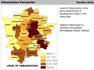
Urbanization Parameter - TALUKA LEVEL. Level of Urbanization is the prime determinant of Development Index in the study area. Highest Urbanization is marked in the greater Ahmedabad, Anand, Nadiad. Development Index TALUKA LEVEL.

E N D
Urbanization Parameter - TALUKA LEVEL Level of Urbanization is the prime determinant of Development Index in the study area. Highest Urbanization is marked in the greater Ahmedabad, Anand, Nadiad.
Development Index TALUKA LEVEL Development Index is observed to be highest in Ahmedabad and Daskroi Talukas, followed by Gandhinagar, Kalol, Mehmadabad, Bavla, Dholka and Khambhat. Out of these, Kalol and Mehmadabad have significant area under present AUDA jurisdiction. While the other three talukas are outside AUDA. The talukas having next range of Development Index are mainly located in North to Ahmedabad, clustering around Gandhinagar.
Proposal & strategy – Population Projection Note: *There is an Addition of 6 lakh projected population because of proposed SIR Greater Ahmedabad = Ahmedabad Urban agglomeration + 4 satellite town ( dehgam, Sanand, Mehmedabad, Kalol) Popultaion projection for Surrounding urban towns are also done i.e Ghandhinagar, Anand, Kheda.
Proposal & strategy – Population Projection As per the proposed gross density (50, 75 and 100 person per hectare) for the projected population (2025) the built up area of the Ahmedabad urban agglomeration will be 1800, 1200 & 900 sq.km.
Conceptual Model for Urban Morphology Model A Regional Road Inner ring road having length of 75 kms and passes along Changodar, Sanand, Kalol, Kadi, Dehgam and Mehemdabad, forming the limit of the AMC. Outer ring road having length of 145 kms form the outer limit of the Metropolitan region. Mehsana, Kapadvanj, Nadiad Tarapur, Bavala and Viramgam are the significant urban location along the outer ring road. Radial roads providing connectivity between the urban centers on the outer and inner ring roads. Radial road 1 - Sanand to Viramgam. Radial road 2 - Kheda to Tarapur. Urban Morphology Well define distribution of urban settlement featuring proper hierarchy, having primacy of Ahmedabad city. Uniform spread, however the major expansion is in south west along the NH, across changodar industrial estate. Figurine projections are proposed along the 4 satellite towns (Dehgam, Sanand, Mehemdabad & Kalol)
Conceptual Model for Urban Morphology Model B Regional Road Inner ring road are proposed same as Model A. Outer ring road does not feature the complete circular loop, however have length of 110 kms and forms the outer limit of the Metropolitan region. It extends from Viramgan to Nadiad via Detroj, Mehsana, and Mansa & Kathlal. Radial roads areproposed same as Model A. Urban Morphology Urban centers are not proposed as to develop the growth centers. The redistribution is proposed to be in continuum to the Ahmedabad city. 9 protruding figurine projections along the main transportation corridor towards Kalol, Gandhinagar, Dehgam, Kathlal, Mehemdabad, Kheda, Dholka, Bavla, and Sanand. These figurine projections will be in contiguous to the existing limits of the Ahmedabad city and features the merging of the adjoining towns.
Conceptual Model for Urban Morphology Model C Regional Road Inner ring road are proposed same as Model B. Outer ring road are proposed same as Model B. Urban Morphology Expansion of the Ahmedabad city is continuous to SIR of sub region. The expansion is linearly aligned along the state high way 6 and extends to Dholka special investment region. Identification of 7 important urban centers along the proposed Delhi-Mumbai industrial freight corridor. Anand, Tarapur, Nadiad and Matar urban centers forms concentrated cluster in the southern east part of the metropolitan region. While Kadi, Viramgam and Detroj are the other three growth centers identified in the north western part of the region Distribution of proposed urban settlement exhibits longitudinal distribution of proposed growth centers. These centers will cater to the logistic services as per the proposed Delhi-Mumbai industrial freight corridor.
Conceptual Model for Urban Morphology Four models are been opted (Varying population density of 50, 75 & 100 person/hectare), so therefore 12 alternatives are proposed.
Delineation of Ahmedabad Metropolitan region Includes – viramgam taluka,Barwala, Sojitra, and Nadiad. Excludes the outer ring road Excludes – part of viramgam taluka,Barwala, Sojitra, and Nadiad. Excludes – Viramgam taluka, and part of Dhandhuka Taluka. Includes SIR. Includes SIR. Includes SIR. Area of 12,930 sq.km. Area of 11,065 sq.km Area of 8980 sq.km
Delineation of Ahmedabad Metropolitan region Largest proposed alternative Includes – kathlal,detroj,ahmedabad,mansa. Excludes – viramgam, Mehmedabad, Kapadganj taluka. Excludes –Dhandhuka Taluka. Excludes SIR. Excludes SIR. Excludes SIR. Area of 14,281 sq.km. Area of 11,930 sq.km Area of 10222 sq.km
Delineation of Ahmedabad Metropolitan region Final proposed alternative option for delineation of Ahmedabad Metropolitan Region Area of 10,222 sq.km
Regional Transportation routes – Existing & Proposed Existing Proposed Road : NH8 is the main artery linking Ahmedabad to Vadodara & Mumbai. Outer ring road, Inner & middle ring road Radial roads, Direct linkage to Bhavnagar
Regional Transportation routes – Existing & Proposed Existing Proposed Railway line: Proposal of Broad gauge connecting Bhavnagar to Anand via Vataman- Tarapur- Petlad. Railway line passing in the Metropolitan region connecting Ahmedabad to Mumbai
Site of Strategic Importance distance Multi Modal Hub Centre - Distances from Ahmedabad to 1. Matar – 35 km 2. Vataman – 55 km 3. Tarapur – 60 km International Air port Distances from Ahmedabad to 1. Matar – 35 km 2. Vataman – 55 km 3. Tarapur – 60 km 4. Bagodara – 65 km 5. Fedra – 80 km
Area of different Metropolitan region Delhi Ahmedabad Surat N C R D A – 30000 SQ.KM 2.51 times Proposed A M R D A – 11930 SQ.KM Proposed S M R D A – 4207 SQ.KM 0.35 times Mumbai Bangalore H M D A – 6655 SQ.KM 0.56 times Hyderabad Proposed B M R D A – 8000 SQ.KM 0.67 times M M R D A – 4355 SQ.KM 0.37 times
Area of different Metropolitan region Hongkong San Fransisco Bangkok AHMEDABAD- SURAT New York