Understanding the Dramatic Impact of the L'Aquila Earthquake: Causes and Consequences
220 likes | 330 Views
The L'Aquila earthquake, measuring Mw 6.3 with a depth of 9.46 km, struck on April 6, 2009, resulting in 308 fatalities and over 1,500 injuries. Its impact was intensified due to the vulnerability of towns that grew without adherence to building codes and were situated in high-risk areas. Historical data suggests that past earthquakes in the Abruzzi region have caused significant devastation. This paper examines the factors leading to the earthquake's drastic effects, emphasizing the need for hazard assessments, risk mitigation plans, and improved building practices in vulnerable regions.

Understanding the Dramatic Impact of the L'Aquila Earthquake: Causes and Consequences
E N D
Presentation Transcript
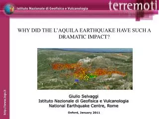
WHY DID THE L’AQUILA EARTHQUAKE HAVE SUCH A DRAMATIC IMPACT? Giulio Selvaggi Istituto Nazionale di Geofisica e Vulcanologia National Earthquake Centre, Rome Oxford, January 2011
Magnitude: Ml=5.9, Mw=6.3 Depth: 9.46 Dead: 308 Injuried :1,500 Displaced: 65,000 Homeless: 22,000 Past earthquakes in Abruzzi 1315: dead 6,000 1703: dead 9,7611706: dead 2,700 1915: dead 33,000 WAS IT REALLY “DRAMATIC”? -Yes, compared with other recent events- It could have been much more severe if it had happened during the morning
HAZARD VULNERABILITY EXPOSURE AWARENESS PREPAREDNESS
SCENARIO FOR XXI CENTURY BASED ON THE PAST TWO CENTURIES • - 500-2000 DEATH+INJURED/YEAR • 50,000-200,000 DEATH+INJURED/CENTURY • 1-2 Bil€/YEAR • 100-200 Bil€/CENTURY 965 M€ IN 7 YEARS 2010-2016
8.861.225 PEOPLE LIVE IN HIGH HAZARD REGION OF CENTRAL-SOUTHERN ITALY
THE GROW OF TOWNS OCCURED DURING THE ’60 AND ‘70, WELL BEFORE BUILDING CODES
VULNERABILITY TOWNS ALSO GROW IN THE WRONG PLACES LIKE ALLUVIAL BASINS WHERE SITE EFFECTS MAY BE LARGE
AWARENESS AND PREPARATIONA questionnaire in the tent camps after the Eq
REASONS WHY IT IS STILL IMPORTANT TO WORK ON BASIC DATA FOR HAZARD ASSESSMENT • The present day hazard map (2004) derives from: • Historical catalogue • Instrumental seismicity • Fault catalogue (for zonation) • Attenuation laws • And does not include: • GPS strain rates data • All what we have learned in the past 6 years
Strain rate field obtained using the method of Holt and Haines (1993) • Color scale = 2nd invariant strain rate tensor • Arrows = principal directions of strain rate
DEVELOP OF NATURAL HIGHLY INSTRUMENTED LAB.Is the AT fault accumulating strain or is it in creeping? What is the role of fluids?
FAULTS CATALOGUE HAVE LARGE UNCERTAINTIES AND INCOMPLETENESS (ES. FAULT RESPONSIBLE OF L’AQUILA EARTHQUAKE WAS NOT KNOWN!)
CONCLUSIONS • A National Plan for Risk Mitigation. • - A long term political strategy for vulnerability reduction (es. basic restructuring), awareness and preparation • A basic research program on earthquake understanding (monitoring) • Establish natural laboratories to study earthquake generation process • Review of earthquake and faults catalogues • Strain rate maps • To develop long and medium-term (time dependent) hazard maps for operational purposes