Download
1 / 17
170 likes | 382 Views
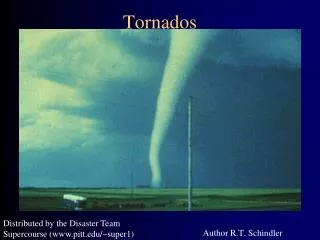
TORNADOS. https://www.meted.ucar.edu/training_course.php?id=3 Mesoscale Meteorology: A Primer for Forecasters. http://www.met.tamu.edu/class/atmo202/Severedir/severe-wx-stu.html. TORNADOS. Ventos extremamente intensos formam -se na base de Cb´s

E N D
https://www.meted.ucar.edu/training_course.php?id=3 • Mesoscale Meteorology: A Primer for Forecasters
http://www.met.tamu.edu/class/atmo202/Severedir/severe-wx-stu.htmlhttp://www.met.tamu.edu/class/atmo202/Severedir/severe-wx-stu.html
TORNADOS • Ventosextremamenteintensosformam-se na base de Cb´s • Geralmenteciclônicos (apesar de pequenosparaseremafetadospelaForça de Coriolis, entretanto, esta tem um papelnasuaformação) • Formasdiversas (colunascilíndricas, funis) • Tamanhos: de 100 a 1500m • Intensidade: velocidades do vento de 65 a 450 km/h • Deslocam-se com velocidade ~50km/h e duramalgunsminutos (podemdurarhoras), cobrindodistâncias de 3 a 4 km • Desenvolvem-se próximo de frentes, cavadospré-frontais, SCM, supercélulas e ciclonestropicais http://www.jhu.edu/~dwaugh1/fluid_earth/fe_4w.htm
Formação • Amesocyclone is formed within supercell � winds move from southerly to westerly direction as move up from ground, which causes a horizontal vortex to be formed. The strong updraft can then tilt this vortex upright. • Mesocyclonestretches, thins and intensifies (conservation of vorticity). A portion of cloud then protrudes from base (�wall cloud�). • A very narrow �funnel cloud� emerges from base of cloud, and a tornado forms when this touches the ground. • The conditions for formation are those for formation of severe thunderstorms: • � low-level flow of moist, warm air, • � upper-level flow of drier, cool air, • � passage of cold front (lifting + rotation). • These conditions are frequently meet in the �Tornado Alley�, especially during spring (warming of surface in winter-summer transition, and favorable synoptic conditions). http://www.jhu.edu/~dwaugh1/fluid_earth/fe_4w.htm
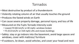
TORNADO DAMAGE / CLASSIFICATION • Most of the damage from tornadoes is caused by the strong winds (and flying objects). • It was thought that the large pressure change (100 hPa over 100m) caused houses to explode (and hence old advice to open windows), but it is now known this is not the reason. • There are very few measurements of tornadoes (they are localized and destroy most instruments), so tornadoes are classified according to their destruction. • The scale used is the Fujita scale (or F-scale) which consists of 6 types: F0 � F5 (weak � strong � violent). Weak tornadoes (F0,F1) are most common (74%), and violent tornadoes (F4,F5) are rare (1%). http://www.jhu.edu/~dwaugh1/fluid_earth/fe_4w.htm
April 16, 2011 North Carolina Tornado Outbreak http://www4.ncsu.edu/~nwsfo/storage/cases/20110416/
Synoptic and Mesoscale Summary- The upper air pattern on the morning of 16 April 2011 featured an impressive eastward advancing upper level trough extending from the western Great Lakes into the lower Mississippi Valley. The 500 hPa trough at 00 UTC had moved eastward and became negatively tilted at 12 UTC with significant height falls of more than 120m noted across the Ohio and Tennessee Valleys. A 90 kt mid-level jet was rounding the base of the 500 hPa trough at 12 UTC across northeast Alabama, northwest Georgia, and far southeast Tennessee with a diffluent pattern noted across Georgia and the Carolinas. At 300 hPa, a strong jet core of 110 kts was located across northern Mississippi, northern Alabama, and southeastern Tennessee. At 850 hPa, a closed low was analyzed over the western Great Lakes with a trough axis extending south along and near the Mississippi River. Another trough axis was located near and just west of the Southern Appalachians in eastern Kentucky, eastern Tennessee, and northwestern Georgia. Ahead of this trough, a region of enhanced south-southwesterly to southerly winds of 50 kts or more was analyzed across the western Carolinas, West Virginia, and western Virginia. A thermal ridge at 850 hPa extended into the Carolinas with dew points ranging into the 9 to 11 degree C range. A strong southeasterly flow at 925 hPa was noted with winds of 35 to 45 kts across central North Carolina. At the surface, a cold front was analyzed near or just west of the Appalachians, extending from eastern Kentucky south across far western North Carolina into Georgia and the Florida panhandle. A warm front noting the leading edge of a warmer, more moist and unstable surface air mass extended west to east across southern North Carolina to the northeastern North Carolina Coast. North of the warm front, surface dew points were generally in the mid to upper 50s with temperatures in the upper 50s to lower 60s. South of the front, dew points climbed into the lower to mid 60s. The setup of synoptic scale features with this event was somewhat similar to thecomposite map of major synoptic scale features typically associated with severe weather outbreaks provided by Barnes and Newton (1983). The regional composite radar at 1158 UTC showed some scattered light to moderate rain showers across the Piedmont and Foothills of North Carolina with some convection developing south of the warm front across South Carolina and Georgia.
Synoptic Environments Associated with Significant Tornadoes in the Contiguous United States JAYSON A. PRENTICE http://www.meteor.iastate.edu/~japrenti/thesis/thesis.pdf A Climatology of Synoptic Conditions associated with Significant Tornadoes across the Southern Appalachian Region by David M. Gaffin and Stephen S. Parker http://journals.ametsoc.org/doi/abs/10.1175/WAF951.1