Download
1 / 1
10 likes | 104 Views
This study aims to detect and analyze recent land use changes in Southwest Ethiopia using multiple spatial scales and factors, such as biophysical and socio-economic variables. The research focuses on understanding the drivers of deforestation and degradation, mapping land use patterns, and correlating changes with various factors. The expected outcomes include a better understanding of land use dynamics, integration of social and natural sciences, and documentation of land use change processes.

E N D
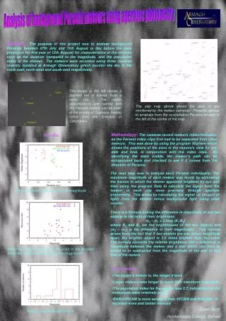
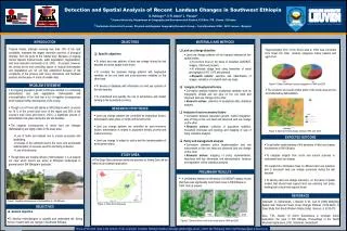
Detection and Spatial Analysis of Recent Landuse Changes in Southwest Ethiopia G. Kefelegn1,2, V. R. Anton2, J. Poesen2 1Jimma University, Department of Geography and Environmental Studies, P.O.Box- 378, Jimma - Ethiopia 2 Katholieke Universiteit Leuven, Physical and Regional Geography Research Group – Celestijnenlaan 200E - 3001 Leuven - Belgium INTRODUCTION OBJECTIVES MATERIALS AND METHODS Tropical forests, although covering less than 10% of the land worldwide, represent the largest terrestrial reservoir of biological diversity, from the gene to the habitat level. Because of ongoing human impactst tropical forests, suffer degradation, fragmentation, and local extinction (Amarnath et al, 2001). At present, however, the driving forces and controlling factors of tropical deforestation and degradation are not yet fully understood because of the complexity of the process with many interactions and feedback systems and because of a lack of reliable data.. • Land use change detection • Land use change patterns will be mapped analysed at two spatial scales: • At province level on the basis of classified LANDSAT-imagery (1984 and present). • At individual village level using timeseries of aerial photographs (1957, 1975 and present). • Research actions: selection and classification of images, validation of compiled land use maps. • Analysis of biophysical factors • Correlation analysis between biophysical variables such as topography, climate and soil type on the one hand and observed land use change on the other. • Research actions: collection of biophysical data, statistical analysis. • Analysis of socio-economic factors • Correlation between population growth, market integration, way of living on the one hand and observed land use change on the other. • Research actions: collection of population statistics, household interviews and typology and mapping of way of living, statistical analysis. • Policy and management analysis • Correlation between policy implementation and law enforcement on the one hand and observed land use change on the other. • Research actions: mapping of policy implementation, interviews with key informants and administrators, literature and legislation review, statistical analysis. • Approximately 30% of the forest area in 1984 was converted from forest into other landuse categories mainly pasture and agriculture. • Specific objectives • To detect and map patterns of land use change during the last decades at various spatial scale levels. • To correlate the observed change patterns with biophysical variables on the one hand and socio-economic variables on the other hand. • To develop a database with information on land use systems of the last decades. • To understand and quantify the role of subsistence and market farming in the household economy. Figure 4. Extent of different landuse categories in 1984 and 2005 PROBLEM STATEMENT • The southern and south central parts of the study area are the most affected by deforestation. • An ongoing population growth in Ethiopia resulted in a continuing deforestation and land degradation. Deforestation and overexploitation of the land has a lot of negative consequences which hamper further development of the county. • Though a lot of forest still stands in SW Ethiopia which accounts for 18 % of the overall land cover of the region and 56% of the country’s total (Gole and Denich, 2001), a significant amount of deforestation took place during the last two decades. • The negative consequences of recent land use changes (deforestation) are highly visible in the study area: • Loss of fertile soil material due to erosion processes and landsliding. • Increase of the sediment load in the rivers and accelerated sedimentation of resevoirs used for electricity production. • Loss of biodiversity • Though there are multiple drivers of deforestation, it is at present not clear which drivers are active in Ethiopian landscapes in general and in SW Ethiopia in particular. • Though there are multiple drivers of deforestation, it is at present not clear which drivers are active in Ethiopian landscapes in general and in SW Ethiopia in particular. 2005 1984 RESEARCH HYPOTHESES • Land use change patterns are controlled by biophysical factors: deforestation takes place on fertile and flat land units. • Land use change patterns are controlled by socio-economic factors: deforestation is related to population density, poverty and market economy. • Land use change is related to policy and the implementation of development plans. Figure 5. Observed forest change between 1984 and 2005 EXPECTED OUTCOME • To get better understanding of the dynamics of land use change mechanisms in SW Ethiopia; • To integrate insights from social and natural sciences to understand land use change • To expand the information base on different land use practices and to document land use change processes during the last decades. • To develop land use change scenario’s on the basis of spatial models that should lead support land use planning and policy making both at local and regional levels. STUDY AREA • The Gilgel Gibe catchment within the province of Jimma Zone will be taken as an example application. PRELIMNARY RESULTS • A preliminary analysis on the bases of LANDSAT imagery shows that there was significantly more forest cover in SW Ethiopia in 1984 than at present REFERENCE Figure1. Negative consequences of deforestation in SW Ethiopia Amarnath. G., Mohammed, I., Manchi, S. M., Carl, B (2008) Modelling Spatial and Temporal Forest Cover Change Patterns (1973-2020): A Case Study from South Western Ghats (India). Sensors, 8, 6132-615. Gole, T.W., Denich, M (2001) Subsistence in mountain forest ecosystem: the case of SW Ethiopia. Proceedings of the World Mountain Symposium, 2001, Interlaken, Switzerland. Figure 2. Map of the study area OBJECTIVES • General objective • To develop methodologies to quantify and understand the driving forces of recent land use change in Southwest Ethiopia. Figure 3. Extent of forest cover in the study area in 1984 and 2005 This is a PhD work done in the context of IUC-JU project. Contacts: Kefelegn Getahun (kefelegn.getahun@ju.edu.et ), Anton Van Rompaey( Anton.VanRompaey@ees.kuleuven.be)