1 / 24

Comparisons of WRF model runs with satellite data in SAL regions

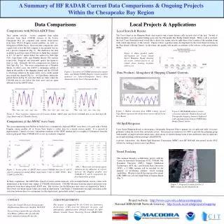
Comparisons of WRF model runs with satellite data in SAL regions. Eddy Hildebrand 30 April 2009. Moisture products. SSMI TPW and MODIS H2O (column-integrated) Low-level: AIRS and WRF at 1000 hPa, MODIS 1000-925 hPa avg. Mid-level: AIRS and WRF at 700 hPa, MODIS 700-300 hPa avg.

josiah
Download Presentation

Comparisons of WRF model runs with satellite data in SAL regions

An Image/Link below is provided (as is) to download presentation Download Policy: Content on the Website is provided to you AS IS for your information and personal use and may not be sold / licensed / shared on other websites without getting consent from its author. Content is provided to you AS IS for your information and personal use only. Download presentation by click this link. While downloading, if for some reason you are not able to download a presentation, the publisher may have deleted the file from their server. During download, if you can't get a presentation, the file might be deleted by the publisher.

E N D

Presentation Transcript


  1. Comparisons of WRF model runs with satellite data in SAL regions Eddy Hildebrand 30 April 2009

  2. Moisture products • SSMI TPW and MODIS H2O (column-integrated) • Low-level: AIRS and WRF at 1000 hPa, MODIS 1000-925 hPa avg. • Mid-level: AIRS and WRF at 700 hPa, MODIS 700-300 hPa avg.

  3. 1000 hPa MMR 16 Sep. cuBMJ-mpK

  4. 1000 hPa MMR 16 Sep. cuBMJ-mpW

  5. 1000 hPa MMR 16 Sep. cuKF-mpW

  6. 700 hPa MMR 16 Sep. cuBMJ-mpK

  7. 700 hPa MMR 16 Sep. cuBMJ-mpW

  8. 700 hPa MMR 16 Sep. cuKF-mpW

  9. Now for T products… • AIRS 700 hPa T • WRF 700 hPa T perturbation

  10. 700 hPa T perturbation (theta – T0) 16 Sep. cuBMJ-mpK

  11. 700 hPa T perturbation (theta – T0) 16 Sep. cuBMJ-mpW

  12. 700 hPa T perturbation (theta – T0) 16 Sep. cuKF-mpW

  13. Wind results… • WRF u-wind at 700 hPa

  14. 700 hPa u 16 Sep. cuBMJ-mpK

  15. 700 hPa u 16 Sep. cuBMJ-mpW

  16. 700 hPa u 16 Sep. cuKF-mpW

More Related