Download
1 / 16
180 likes | 344 Views
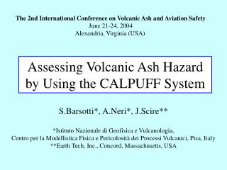
The 2nd International Conference on Volcanic Ash and Aviation Safety June 21-24, 2004 Alexandria, Virginia (USA). Assessing Volcanic Ash Hazard by Using the CALPUFF System. S.Barsotti*, A.Neri*, J.Scire** *Istituto Nazionale di Geofisica e Vulcanologia,

E N D
The 2nd International Conference on Volcanic Ash and Aviation SafetyJune 21-24, 2004Alexandria, Virginia (USA) Assessing Volcanic Ash Hazard by Using the CALPUFF System S.Barsotti*, A.Neri*, J.Scire** *Istituto Nazionale di Geofisica e Vulcanologia, Centro per la Modellistica Fisica e Pericolosità dei Processi Vulcanici, Pisa, Italy **Earth Tech, Inc., Concord, Massachusetts, USA
Outline • Motivation and objective • The CALPUFF modeling system structure (geophysical pre-processors, meteo diagnostic code CALMET and the dispersion code CALPUFF) • Results of a preliminary application of CALPUFF to the July 2001 Mt.Etna’s eruption • Conclusive remarks
Motivation During the last eruptions of Mt.Etna (2001 and 2002) the relatively minor explosive activity renewed the interest in the volcanic risk due to the presence of ash in the atmosphere Objective To develope a predictive modeling tool - able to forecast the movement and properties of an ash cloud in the atmosphere - to be used during a volcanic crisis
CALPUFF Modeling System (Scire et al. 2000) • Developed in the 90’s by Sigma Research Corporation (now part of the Earth Tech, Inc.) as air quality modeling system • Proposed by U.S. EPA as a Guideline model for regulatory applications System Flowchart Meteo data (MM5 or CALETA) Terrain elevation data (TERREL) Landuse data (CTGPROC) CALMET(diagnostic meteo processor) Emissiondata CALPUFF (Lagrangian dispersion code)
CALMET (diagnostic meteo processor) • Input data: P, Elevation m.s.l, T, wind direction, wind speed, vertical velocity, relative humidity at different levels and every three hours • Output data: U, V, W wind components, T and all the micrometeorological variableson a specified grid and every hour HOW DOES IT WORK? Prognostic code output Initial guess field • Refinement by interpolation • Correction by orography • Divergence minimization Terrain effects Step 1 wind field • Weighted observed data • Divergence minimization Objective analysis Step 2 wind field
CALPUFF • It is a Lagrangian dispersion model that treats the emitted material as a sequence of packets, or puffs, containing discrete quantity of particles. Each puff is then described with a Gaussian distribution and subjected to advection, diffusion and gravity • Selected a set of receptors, gridded or discrete, in the domain investigated, CALPUFF computes hourly the concentration and flux of particles at these points • Main features: • Different granulometric classes • Time dependent emission and meteo data • Dry and wet deposition • Buoyant area source • Domain from tens of ms to hundreds of kms • from the source
The basic equation is the material mass in the puff and is a function of the sampling interval. Its variations are due to removal and to chemical processes. The sigmas are the horizontal Gaussian dispersion coefficients and are functions of the sampling interval. They include effects of atmospheric turbulence, plume buoyancy and lateral (crosswind) scale of an area-source. is the vertical term of the Gaussian distribution. It takes account for the vertical diffusion due to the mixing lid and plume buoyancy and is a function of the distance from the source.
Area Source Plume Rise • One of the main features of CALPUFF is the capability of treating the case of very hot area source. Using a file containing all the information related to the source, the code solves the three fundamental equations of conservation of mass, momentum and energy. The equation system is (Weil 1988):
A First Volcanological Application(Etna July 2001) • Simulation parameters • Computational domain • Cell numbers 100X100 • Δgrid=2km • Grid origin xUTM(km) = 411.021 • yUTM(km) = 4095.136 • Period • 20-24 July 2001 • Geo and meteo input data • GTOPO Global data ~900m res. • USGS Global land-use data set ~900m res. • ECMWF meteo data 2.5*2.5 degree res. • NOAA meteo data 2.5*2.5 degree res.
Source data Coltelli and Macedonio, GNV Ass. 2001 • For the rising plume: • Exit velocity 25-75 m/sec • Exit temperature 100-300 °C • Initial radius 25-75 m • Ground elevation 2550 m • Emission height a.g. 100 m Photo by Boris Bencke • For the puff description: • Particles diameter 3-64 µm • Particles density 2500 kg/m^3 • Emission rate 10^2-10^3 kg/sec Photo by Tom Pfeiffer
General features of ash dispersal Ash concentration on air (Kg/m^3)
Temporal Evolution of the Emission Point • The code computes the effective height and the downwinddistance from the vent where a puff description of the emission begins
Ash Cloud Concentration (1)Vertical distribution of ash concentration along the dispersal axis • Vertical distribution of particle concentration at a fixed time and different distances from the vent • Temporal evolution of the vertical concentration at 25 km from the vent
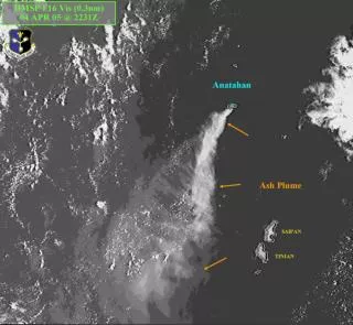
The sensitivity to meteo data • Image acquired by SeaStar Satellite at 1100UTC on 20July 2001 • NOAA • ECMWF • Concentration (kg/m^3) on air summed on different vertical levels • Vertical distribution of wind direction
The sensitivity to meteo data • Image acquired by SeaStar Satellite at 1129UTC on 22July 2001 • NOAA • ECMWF • Concentration (kg/m^3) on air summed on different vertical levels • Vertical distribution of wind direction
Conclusive Remarks • CALPUFF is a promising system for real-time forecast of volcanic ash dispersal produced by weak explosive activity • High resolution meteo data and accurate description of plume rise are critical for a correct modeling of plume dispersal • Definition of well-known test cases is fundamental for the validation of the code with observed data • Real-time measurements of the eruption plume and dispersal are crucial in order to obtain reliable forecasts