Download
1 / 55
550 likes | 570 Views
Explore the challenges of geostationary RFI on AMSR-E data and propose adaptive algorithms to mitigate its effects on sea surface temperature (SST) retrievals.

E N D
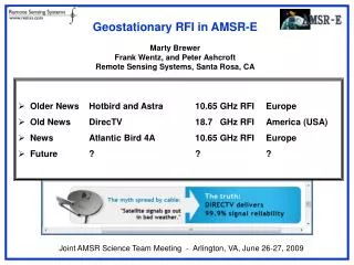
AMSR-E RFIUpdate - Towards RFI 2.0 - Adaptive Algorithms 1.0 Marty Brewer and Kyle Hilburn Frank, Carl, Chelle, et. al. Remote Sensing Systems AMSR Science Team Meeting Portland, Oregon, 2012.Sep.11-12
RFI • Surface Based (~7GHz) • Ascension Island, Hawaii, Netherlands, etc. • GeoStationarySatellites (11GHz, 18GHz) • “Space Based” • “Ocean Reflected”
RFI • RFI 1.0 • We know where it’s coming from. • We can filter it. • RFI 2.0 • We don’t really know where it’s coming from. • We can retrieve around it.
Fishing for Geostationary RFI • Data used: AMSR-E, March-September 2011 (7 months) • RFI is very much a moving target • Calculated the longitude and latitude where the reflection of the boresight vector from the surface crosses geostationary altitude (35,786 km) • For this analysis: • histograms of geostationary crossing longitude at 0.1 deg resolution • maps of fraction of observations affected by RFI • RFI defined as: SST or Wind diff > threshold • 4 different thresholds (1, 3, 6, and 9 K or m/s) • Required geostationary latitude to be within +/- 5 deg of equator • Removed: land, ice, rain, sun glitter; used both asc/dsc passes
SST LO-VL > 1 K (Weak RFI) Smooth Seas (wind speeds < 7 m/s) Glassy Seas (wind speeds < 3 m/s)
SST LO-VL > 3 K (Medium RFI) Smooth Seas (wind speeds < 7 m/s) Glassy Seas (wind speeds < 3 m/s)
SST LO-VL > 6 K (Strong RFI) Smooth Seas (wind speeds < 7 m/s) Glassy Seas (wind speeds < 3 m/s)
SST LO-VL > 9 K (V.Strong RFI) Smooth Seas (wind speeds < 7 m/s) Glassy Seas (wind speeds < 3 m/s)
Wind MD-LO > 1 m/s(Weak RFI) Smooth Seas (wind speeds < 7 m/s) Glassy Seas (wind speeds < 3 m/s)
Wind MD-LO > 3 m/s(Medium RFI) Smooth Seas (wind speeds < 7 m/s) Glassy Seas (wind speeds < 3 m/s)
Wind MD-LO > 6 m/s(Strong RFI) Smooth Seas (wind speeds < 7 m/s) Glassy Seas (wind speeds < 3 m/s)
Wind MD-LO > 9 m/s(V.Strong RFI) Smooth Seas (wind speeds < 7 m/s) Glassy Seas (wind speeds < 3 m/s)
Geostationary Fishing Results • The analysis finds good agreement between geostationary longitude histogram peaks and the longitudes of: • HotBird (13.0°) • Astra (19.2°) • Astra (28.2°) • EutelsatW2A (10.0°) • Presence of land can give peaks off the nominal longitudes • AtlanticBird4 (352.8°) peak is 5-10° west of nominal longitude • For 18.7 GHz RFI: DirectTV peaks are about 10° west and east of the nominal longitudes (257.2° and 260.8°)
Geostationary Fishing 2.0 • Assume GeoStatSats are equatiorial • Look at latitudes as well as longitudes • Geostationary Altitude Sky Maps
SST LO-VL > 1 K (Weak RFI) Smooth Seas (wind speeds < 7 m/s)
SST LO-VL > 1 K (Weak RFI) Glassy Seas (wind speeds < 3 m/s)
SST LO-VL > 6 K (Strong RFI) Smooth Seas (wind speeds < 7 m/s)
SST LO-VL > 6 K (Strong RFI) Glassy Seas (wind speeds < 3 m/s)
SST LO-VL > 6 K (Strong RFI) Glassy Seas (wind speeds < 3 m/s)
SST LO-VL > 6 K (Strong RFI) All Seas (all wind speeds)
Wind MD-LO > 1 m/s(Weak RFI) Smooth Seas (wind speeds < 7 m/s)
Wind MD-LO > 1 m/s(Weak RFI) Glassy Seas (wind speeds < 3 m/s)
Wind MD-LO > 6 m/s(Strong RFI) Smooth Seas (wind speeds < 7 m/s)
Wind MD-LO > 6 m/s(Strong RFI) Glassy Seas (wind speeds < 3 m/s)
Wind MD-LO > 6 m/s(Strong RFI) Glassy Seas (wind speeds < 3 m/s)
Wind MD-LO > 6 m/s(Strong RFI) All Seas (all wind speeds)
Geostationary RFI 1.0 • Implemented L2A Version B05 (August, 2005) • Glint Angles computed to 13.0° E and 19.2° E (at geostationary altitude) • L2A V10 (April, 2009) : 99.2° W and 102.8° W for data after July, 2007
Geostationary RFI 2.0 L2A Proposed New Swath Names: “Geostationary_Altitude_Reflection_Latitude” “Geostationary_Altitude_Reflection_Longitude”
Towards: Adaptive Algorithms 1.0 Mitigating the Effect of 11 GHz RFI on AMSR-E SST Retrievals Kyle, Aug 2012
2002, Descending Passes Standard Algorithm 11 GHz RFI Mitigation 7GHz RFI Color = Standard Deviation of AMSR-E – Reynolds SST
2003, Descending Passes Standard Algorithm 11 GHz RFI Mitigation 7GHz RFI Color = Standard Deviation of AMSR-E – Reynolds SST
2004, Descending Passes Standard Algorithm 11 GHz RFI Mitigation 7GHz RFI Color = Standard Deviation of AMSR-E – Reynolds SST
2005, Descending Passes Standard Algorithm 11 GHz RFI Mitigation 7GHz RFI Color = Standard Deviation of AMSR-E – Reynolds SST
2006, Descending Passes Standard Algorithm 11 GHz RFI Mitigation 7GHz RFI Color = Standard Deviation of AMSR-E – Reynolds SST
2007, Descending Passes Standard Algorithm 11 GHz RFI Mitigation 7GHz RFI Color = Standard Deviation of AMSR-E – Reynolds SST
2008, Descending Passes Standard Algorithm 11 GHz RFI Mitigation 7GHz RFI Color = Standard Deviation of AMSR-E – Reynolds SST
2009, Descending Passes Standard Algorithm 11 GHz RFI Mitigation 7GHz RFI Color = Standard Deviation of AMSR-E – Reynolds SST
2010, Descending Passes Standard Algorithm 11 GHz RFI Mitigation 7GHz RFI Color = Standard Deviation of AMSR-E – Reynolds SST
2011, Descending Passes Standard Algorithm 11 GHz RFI Mitigation 7GHz RFI Color = Standard Deviation of AMSR-E – Reynolds SST