Download
1 / 42
460 likes | 603 Views
Learn about Geometrics' 30-year history of magnetometer development, applications, sensor noise analysis, earth's magnetic field, and using G-858 and G-856 magnetometers for accurate surveys. Training includes hardware setup, software processing, and practical review sessions.

E N D
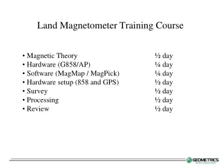
Magnetic Theory ½ day • Hardware (G858/AP) ¼ day • Software (MagMap / MagPick) ¼ day • Hardware setup (858 and GPS) ½ day • Survey ½ day • Processing ½ day • Review ½ day Land Magnetometer Training Course
GEOMETRICS MAGNETOMETERS-tools for exploration Applications: • Map Geology for Mining, Oil/Gas Exploration • Environmental Survey for Tanks, Barrels • Locate Utilities, Pipelines • Military Uses, UXO-EOD, De-mining • Archaeology • Used in Land-Marine-Airborne Surveys
GEOMETRICS: a 30-year history of building magnetometers • 1969: G-801 & G-803 marine and airborne proton magnetometers • 1971: G-806 land and marine proton magnetometer • 1973: G-816 portable proton magnetometer • 1977: G-826 portable digital magnetometer • 1981: G-856 portable memory magnetometer • 1983: G-811 marine magnetometer • 1991: G-822L military magnetometer • 1992: G-825 military diver-held magnetometer • 1992: G-822A airborne cesium magnetometer • 1995: G-858 portable cesium magnetometer • 1996: G-880 marine cesium magnetometer • 1997: G-823A airborne cesium magnetometer with counter • 1998: G-881 marine light-weight cesium magnetometer • 2003: G-882 marine cesium magnetometer • 2005: G-859 cesium mining magnetometer • 2009: UAV, AUV testing • 2013: G-860 land cesium magnetometer • 2014: G-862RBS cesium base station
Earth’s Magnetic Field – Solar effects Earth’s Magnetic Field:detection of magnetic anomalies • Earth’s dipole (N-S) magnetic field is produced by internal iron core dynamo effect. Charged particles from the sun cause a bow shock wave in the magnetosphere which leads to Diurnal Variations • Earth’s dipole magnetic field is perturbed by relatively localized contrasts in magnetization. • Magnetization contrasts are caused by ferrous debris, vessels, pipelines, communication cables, magnetic minerals (predominantly magnetite). • With magnetometers, one can measure the total field to detect the magnetic anomalies associated with contrasts.
Optional Diurnal / Base Station Monitor Use either G-858 or G-856 Magnetometers Monitor Magnetic Diurnal Variations Magnetometer in fixed location Synchronized clocks 1-30 second sample rate Use for correction of survey data Produce more accurate magnetic maps
Gradiometer Transverse Layout G-858 CESIUM GRADIOMETER WITH agGPS-114/132 STEERING
Standard Survey Acquisition Swath Spacing
GPS Differential Corrections Coast Guard Beacon OmniStar (On shore only without special license) Racal (On shore only without special license) RTCM RTK Known Antenna and Satellite positions and frequencies
Software capabilities • Import G-858 magnetometer (1 or 2 sensors) • Convert GPS Lat / Long to UTM XY coordinates • Correct for GPS offset from Magnetometer sensor • Perform Spike filtering • Import G-858 or G-856 base station data • Merge Base Station data with survey Data • Export in Surfer or Geosoft format
Surfer Software Capabilities • Windows based program for professional displays • Grid and contour G-858 data • Display sample locations on contour map • Various types of displays for interpretation • Export Windows Metafile and ASCII grid files for MagAID
RAW DATA MANUAL SMOOTHING 3 POINT RUNNING AVERAGE MagPick – Filtering theory