Download
1 / 42
430 likes | 689 Views
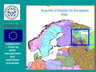
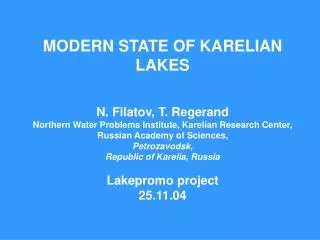
MODERN STATE OF KARELIAN LAKES N. Filatov , T. Regerand Northern Water Problems Institute, Karelian Research Center, Russian Academy of Sciences, Petrozavodsk, Republic of Karelia, Russia Lakepromo project 25.11.04. Republic of Karelia on European map.

E N D
MODERN STATE OF KARELIAN LAKESN. Filatov, T. RegerandNorthern Water Problems Institute, Karelian Research Center, Russian Academy of Sciences,Petrozavodsk, Republic of Karelia, RussiaLakepromo project25.11.04
Republic of Karelia- territory 172 000 km2, occupy 1 % of Russian territory - region is very reach by forests, mineral resources and waters - there are about 61 000 lakes in the regioninclude parts of largest lakes of Europe: Ladoga and Onega.
Main water-ecological problems now and near future:- water pollution from paper-meal industry- mineral pollution of non-ferrous metal industries- eutrophication of surface waters - acidification of water bodies - drinking waters problems - planned pipe-line of Sthockman natural gas deposit (from Barents Sea)
Water bodiesof Karelia(Lakes and riverscovers about 21 %of the territory.About 61000 lakesand 30000 rivers, including the Largest EuropeanLakes - Ladoga and Onego)
Surface waters in Karelia is formed under the conditions of the poorly-soluble parent rocks of the Baltic crystalline shield, well-washed quaternary deposits and high paludification of the territory. The natural quality of the water is modified by sewage discharges, agricultural practices, land reclamation and pollution from atmospheric precipitation during transboundary transports.
Ground waters in Karelia • are confined to sandy quaternary deposits and the upper fissured zone of crystalline rocks. Only in the south of the republic there are small areas on the margins of the Leningrad and Moscow artesian basins. • Mineralisation of the ground waters varies from 0.03 to 1.0 g/l. Waters with high mineralisation are developed locally. • Radon-rich waters with concentration of more than 185 Bk/l are found to the north of Lake Ladoga, east and west of Lake Onego and in central Karelia.
Main directions of NWPI activities • The Northern Water Problems Institute, Karelian Research Centre, Russian Academy of Sciences (NWPI KRC RAS) is a scientific organization with a status of the state institution. • The main aim of Institute activities are fundamental research in the field of hydrology and adjoining natural sciences and in applied research related to the study, rational use and preservation of water resources. • The main directions of Institute activity are the assessment of water-ecological potential and development of the scientific basis for the management of water resources of European North of Russia.
Observed (up to 2000) and modeled for G-scenario and GA-scenario (broken line) time series of air temperature and precipitation for the territory of North-West of Russia. All values are 15-year moving averages.
Climatic Map of the region for January and July
Mean annual air temperature for the studied region for present period (1950-1999) and in future (2000-2050) in accordance with two ECHAM-4 scenarios
The climate and water regime changes will demand the changes in management of basic branches of economy of the region (forestry, hydroelectric power industry, hydroengineering building, shipping etc.)
In 2003, the “Russian Federation National Programme for Water Use in the Long Term” was adopted, aiming to co-ordinate and unify all existing federal and regional programmes concerning the use and protection of water resources. Important current tasks: to develop a background for the water quality monitoring network in Karelia. - to classify water resources of Karelia with due regards to the Russian and international WFD water quality standards.
Location of the basic hydrometeorological stations in Karelia
Classifications of quality of natural Karelian surface waters • Water quality classification realized according of special Instructions (norms) of Governmental institutes. • There are many types of water quality classification in Russia. Some of them concern with the consumption using (drinking water, for fishery ) or only single parameter consider. • The others are based on the principles of permissible limited concentration (PLC). • these types comprise considerable range of water bodies in the different geographical and climatic zones and do not take into account the regional features.
The standard measurements under monitoring Monitoring parameters in NWR water objectsluded: Physical and Chemical parameters: Temperature, electric conductivity, pH, Eh, transparency, suspended matter, color; total ions, Ca+2, Mg+2, Na+1, K+1, HCO3-1, SO42, Cl-1, fluorides, CO2, O2, per cent saturation with oxygen, permanganate oxidability, BOD5, organic carbon (C), phenols, oil products, lignosulphanates, total, mineral, suspended phosphorus (P), organic, ammonium, nitrate, nitrite nitrogen (N), total and suspended iron (Fe), silicon (Si), manganese (Mn), lithium (Li), aluminum (Al), heavy metals: Zn, Cu, Pb, Cd, Ni, Cr. But usually limited parameters apply during of water monitoring of HMS. Biotic parameters: Bacterioplankton: abundance, number of saprophytes, coli-index, Phytoplankton and zooplankton: abundance, biomass, number of species, saprobity coefficient, major taxonomic groups and dominant species. Benthos: abundance, biomass, saprobity coefficient or Woodywiss index, the main dominant groups or indicator species.
The monitoring Field measurements from the NWPI vessel“Ecolog “on Lakes Ladoga and Onega.
Water Quality classification High – Oligohumic ( colour up to 40 degrees), Oligotrophic (Ptotal up to 12 g/l, Chl “a” up to 3g/l, Fe up to 0,2 mg/l, pH – 6,5-8,0 Good– Mesohumic, Mesopolyhumic ( colour 30-120 degrees), (Oligo- Mesotrophic (Ptotal 8-25 g/l, Chl “a” up to 10g/l, Fe 0,1-0,5 mg/l, pH – 6,2-8,5 Satisfactory - Any water body with pH 5,5-6,2 eutrophic (Ptotal 30-50 g/l, Chl “a” 10-30g/l), Polyhumic ( pH > 6,5, Fe 0,5-1,5 mg/l, color up to 200 degrees) Low – Any water body with pH < 5,5, Polyhumic ( pH < 6,2, Fe > 0,7 mg/l, color > 160 degrees), highly eutrophic (Ptotal > 50 g/l, Chl “a” >30g/l. Polluted
Comparison of classifications of water quality according of the Finnish and Russian techniqueThere are 5 classes of water quality it were in Finland according of previous classification. The classification is developed on the basis of normative indexes adopted in Finland for the water bodies use with the purposes of recreation, fish-breeding and as source of drinking water supply.
Water quality classification of lakes and river of river Shuja basin The basic difference is a little bit other treatment of waters humus properties and, as a consequence, reference of water body to different classes of quality.
Karelian diamond is Kizhi Island on Onega Lake with old wooden churches
Some proposals The selection of criteria of classification should be performed, assume constitution and acting norms in Russian Federation. A very important task is to organise of inter-calibration of the methods of investigations, restoration and control of water objects and sources of pollution, waste water and emissions, and data base with EU countries.
Transboundary’s lakesRepublic of Karelia, Russia has a very long (more them 700 km) border with EU. There is a requirement that in the transboundary lakes the implementation will be carried out by cooperation with the border states.The joint Russian-Finland monitoring of the lakes included of lakes directly receiving sewage or located within its spread zone, as well as lakes lying far from industrial pollution zone.
Transboundary’s lakesunder joint investigations:Puhajarvi&in Friendship’s parklakes.Lake Prijginscoe
Another possible objects are Lake Venduri or crossborder lake Puhajarvi
Some parameters of Lake Prijginscoe • 23.6 km 2- area • 4.5 km - length • 1.6 -wide • 7.5 - Depth. • 314.9 km 3 water volume • 1.2 retention time • 0.6- water level fluctuations • Miniralisation is about 26,3 mg/l • oxigen -9,3 mgО2/l or 81% • pH- 6,33 до 7,00 • Color -55 до 96 • BOD5 - 0,5 до 2,23 мгО2/л • Organic matters 20,0 до 26,6 mg. /l • High contents of phosphorus and nitrogen This is a typical Karelian lake
About 5000 inhabitants on the shore of the lake. • A lot of cottages and small enterprises • municipal waters directed out of watershed. • A lot of motor boats. • Polluted waters with the high contents of nutrients arrive to the lake from a small cottages and private agricultural farms. • Population to use surface waters of the lakes for the drinking purposes and swimming.
As a result – • Water quality is rather low (3-th class). • Waters of the lake is an eutrophic. • Waters are not corresponding to drinking waters standards. In near future lake it will be use more for tourism and recreations.
Measures for improving of the situation and restoration of the lake • It will be use ground waters for drinking purposes. • It will be decrease loading of nutrients on the watershed and shore zone. • It will be apply experience of Lakepromo project
It was developed for the North -Climate Data Access System (CLIMAS). //nwpi.krc.karelia.ru/climas