Download
1 / 40
400 likes | 421 Views
The Desktop Weather-Forecast System: Overview and Case Study of a Spring Flooding Event in the Caucasus Mountains. Jim Kinter, Brian Doty, Eric Altshuler, Mike Fennessy Center for Ocean-Land-Atmosphere Studies Calverton, Maryland USA. Desktop Weather-Forecast System. Opportunity.

E N D
The Desktop Weather-Forecast System: Overview and Case Study of a Spring Flooding Event in the Caucasus Mountains Jim Kinter, Brian Doty, Eric Altshuler, Mike Fennessy Center for Ocean-Land-Atmosphere Studies Calverton, Maryland USA
Desktop Weather-Forecast System Opportunity • Global weather forecasts are freely available from US National Weather Service (NWS) - data is provided at 1º and 0.5º resolutions • High-resolution (20 km mesh or finer) regional weather forecasts can be produced with mesoscale models, nested in global forecasts Problem • Three barriers to using current operational technology: • Global data sets are very large in volume and granularity • Large communications bandwidth is required to obtain them • Data assimilation and global numerical weather prediction (NWP) models are very large calculations • Supercomputers are required to run them • Experts in NWP and supercomputing run global and regional models • Cadre of NWP and supercomputer experts must be trained
Desktop Weather-Forecast System Solution • Desktop Weather-Forecast System (DWS) Combines • Distributed data access and analysis technology (GrADS Data Server) • US NWS regional weather prediction model (workstation Eta)
NCEP Global Weather Forecasts Desktop Weather-Forecast System NWS COLA Global Weather Forecasts GrADS Data Server Region-Specific ICs & Lateral BCs WWW Regional NWP Model
Desktop Weather-Forecast System Enables real-time weather forecasts through: • Easy access to real-time initial and boundary conditions data • Easy configuration of regional NWP model for any locality in the world • Readily available, low-cost personal computing hardware/software • Moderate speed Internet connection
Desktop Weather-Forecast System • Advantages: • Runs on low-cost computers such as PCs (Linux); also runs on UNIX workstations; capable of utilizing multiple processors via MPI • Includes easy to use scripts for selecting domain, running a forecast and displaying model output • Provides a unique capability to: • View local or regional weather observations • Create locally-relevant custom displays • Make a regional weather forecast • Graphically merge local weather observations and analysis/forecast products
Desktop Weather-Forecast System Ease of use: • Point and click interface to set up region the first time • Automated access to US NWS global NWP model output for • Atmospheric initial conditions • Initial soil wetness, snow depth • Surface boundary conditions (sea surface temperature, sea ice) and lateral boundary conditions (atmospheric circulation) • Automated linkage to powerful desktop display program (GrADS) to visualize results of forecast • Full documentation for getting data, running forecast
Desktop Weather-Forecast System Current Status Costa Rica • COLA provided DWS to hydromet group already making use of PC-Eta from other source
Desktop Weather-Forecast System Current Status Costa Rica • COLA provided DWS to hydromet group already making use of PC-Eta from other source Vietnam • DWS software-only installation provided by COLA • Currently in use for experimentation
Desktop Weather-Forecast System Current Status Costa Rica • COLA provided DWS to hydromet group already making use of PC-Eta from other source Vietnam • DWS software-only installation provided by COLA • Currently in use for experimentation Senegal • DWS turnkey system provided by COLA • Currently in use for real-time NWP
Desktop Weather-Forecast System Current Status Costa Rica • COLA provided DWS to hydromet group already making use of PC-Eta from other source Vietnam • DWS software-only installation provided by COLA • Currently in use for experimentation Senegal • DWS turnkey system provided by COLA • Currently in use for real-time NWP El Salvador • DWS turnkey system provided by COLA • Currently in use for real-time NWP
Desktop Weather-Forecast System Current Status Costa Rica • COLA provided DWS to hydromet group already making use of PC-Eta from other source Vietnam • DWS software-only installation provided by COLA • Currently in use for experimentation Senegal • DWS turnkey system provided by COLA • Currently in use for real-time NWP El Salvador • DWS turnkey system provided by COLA • Currently in use for real-time NWP Peru • DWS turnkey system provided by COLA • Currently in use for real-time NWP
Desktop Weather-Forecast System Current Status Vietnam, Senegal, El Salvador and Peru • Hundreds (at least one year in most cases) of daily forecasts (3 days lead time) made for each domain at COLA • Results of real-time weather forecasts posted on COLA web site for use by in-country meteorologists • Spatial resolution: 22 km with 50 vertical levels (*) (*) Vietnam was configured at 32 km X 45 levels due to CPU limitations
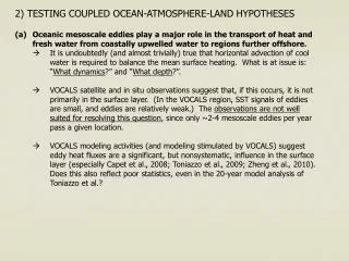
Desktop Weather-Forecast System Test Cases for Caucasus Region Case Study • April 2005 - Period of catastrophic flooding in Georgia … not well predicted, substantial damage Hypothesis • Flooding due to two causes: • Slow-moving disturbance that produced substantial precipitation in high mountain regions of western Georgia • Preceding period of very warm days melted much of the snow in the mountains • Forecasts with 2-3 days lead time could have averted disaster
Desktop Weather-Forecast System Test Cases for Caucasus Region Issues • Region is very challenging for NWP • High terrain • Situation of domain between large bodies of water to the east and west, semi-arid region to the south and temperate forest region to the north • Very little verification data readily available • Limited number of stations with rain gauges • Satellite-based precipitation estimates are not reliable in regions very high variable terrain
Desktop Weather-Forecast System Test Cases for Caucasus Region • Eta model (same as NWS NAM) specifications • Horizontal resolution: 22 km (60-second time step) • Domain: centered at 42ºE,39ºN, 32º long., 24º lat. • Vertical resolution: 50 levels (top pressure 25 hPa) • Hydrostatic dynamics with Kain-Fritsch convection • Computer specifications • Dell Precision Workstation 470, dual Xeon processors (3.4 GHz), 6 GB total memory, 500 GB total disk • Red Hat Linux; Intel Fortran 9.0 with Intel MPI 2.0 • Wall clock time for 72-hour forecast: 50 minutes (Excludes data acquisition)
Desktop Weather-Forecast System Test Cases for Caucasus Region Experiment • Regional 72-hour re-forecast using DWS, 16-30 April 2005, initialized each day at 00UTC • Real initial conditions and lateral boundary conditions taken from archive of global NWP model output (US NWS Global Forecast System - GFS - at 1º X 1º X 26 levels) • Real sea surface temperature conditions obtained from NOAA NESDIS (RTG_SST) • Real snow initial conditions obtained from US Air Force, US NWS • Comparison with GFS forecasts made in real time
Desktop Weather-Forecast System Test Cases for Caucasus Region Verification • CMORPH satellite-based estimate of precipitation (http://www.cpc.ncep.noaa.gov/products/janowiak/cmorph.html) • Combines microwave precipitation estimates (high spatial resolution) and infrared (coarse spatial, high temporal resolution) data to propagate features • Has known limitations in estimating precipitation over high terrain - causes specific problem in Caucasus region where no precipitation is estimated over highest elevations
22Apr05 23Apr05 24Apr05 25Apr05 26Apr05 27Apr05 Sequence of CMORPH satellite-based precipitation estimates for 22-27 April 2005
Sequence of CMORPH satellite-based precipitation estimates for 22-27 April 2005 (zoomed in on Europe-North Africa region to show progression of disturbance) 22Apr05 23Apr05 24Apr05 25Apr05 26Apr05 27Apr05
Desktop Weather-Forecast System Test Cases for Caucasus Region Results of Experiment - I • Both the global NWP model (GFS) and the regional model (DWS) produced reasonable forecasts of the rainfall and temperature over the region with up to 3 days lead time • DWS produced sharper representations of precipitation areas, with substantially higher amounts concentrated in small areas • Precipitation above 1200 m elevation, especially relevant in test cases, significantly higher and more concentrated in DWS than in GFS forecasts
Daily Precipitation Totals 19 April 2005 20 April 2005 21 April 2005 DWS 24-48 hr fcst OBS GFS 24-48 hr fcst
Daily Precipitation Totals 22 April 2005 23 April 2005 24 April 2005 DWS 24-48 hr fcst OBS GFS 24-48 hr fcst
Daily Precipitation Totals 25 April 2005 26 April 2005 27 April 2005 DWS 24-48 hr fcst OBS GFS 24-48 hr fcst
Daily Precipitation Totals 28 April 2005 29 April 2005 30 April 2005 DWS 24-48 hr fcst OBS GFS 24-48 hr fcst
Desktop Weather-Forecast System Test Cases for Caucasus Region Results of Experiment - II • Major warm spell in middle of April 2005 caused over half of the snow in the high mountains to melt over a 10-day period • Both models predict the snow melt, but both also over-estimate the rate of snow melt • DWS does a much better job of representing both the initial snow pack and the amount of melting
Daily Mean Temperature (°C) 17 April 2005 22 April 2005 25 April 2005 29 April 2005 DWS DWS - sharp resolution of topography - below freezing in highest elevations GFS - coarse resolution of mountains GFS
Daily Mean Temperature (°C) 17 April 2005 22 April 2005 25 April 2005 29 April 2005 Clear warming in middle of period DWS DWS - sharp resolution of topography - below freezing in highest elevations GFS - coarse resolution of mountains GFS
Daily Precipitation Totals and Daily Mean Temperature (averaged 40°-48°E, 41°-44°N, above 1200 m elevation) 40 mm 23-26Apr2005 12 mm 19Apr2005 Precip DWS (red) GFS (green) 8°C average T 21-24Apr2005 Temperature DWS (red) GFS (green)
Snow Depth (liquid water equivalent, mm) 17 April 2005 21 April 2005 25 April 2005 29 April 2005 DWS DWS - sharp features of snow GFS - coarse features due to poor resolution of mountains GFS
Snow Depth (liquid water equivalent, mm) 17 April 2005 21 April 2005 25 April 2005 29 April 2005 Snow decreases by >50% over 12 days DWS DWS - sharp features of snow GFS - coarse features due to poor resolution of mountains GFS
Snow Depth (liquid water equivalent, mm) (averaged 40°-48°E, 41°-44°N, above 1200 m elevation) The blue line shows the initial snow depth for each day from 16 April to 30 April 2005. The red lines show the DWS forecast values, and the green lines show the GFS forecast values. The snow decreases by 18 mm liquid water equivalent over the period in the mountain areas. Both model forecasts melt the snow too rapidly, with the DWS being more accurate.
Desktop Weather-Forecast System Lessons Learned • Low cost operational NWP at high resolution for regional scales can be implemented in developing countries • Best method for transferring technology: • Obtain hardware at COLA • Install complete system and run full real-time test at COLA • Ship “shrink-wrapped” system to target country • Access system remotely from COLA to ensure correct setup • Largest delays introduced by human factors • Communication limitations with non-English-speaking colleagues • Shipping logistics (how to ship with certainty of delivery, who pays the duty, etc.) • BUT - In-country staff capability surprisingly high
Desktop Weather-Forecast System Recent Developments and Future Plans • Replace the Eta model with the Weather Research and Forecasting (WRF) model • WRF has been the operational regional NWP model at the US NWS since June 2006; Eta model is no longer maintained • A version of WRF has been developed for ease of use and efficient, reliable data acquisition even with modest Internet bandwidth - philosophy is similar to DWS-Eta system • WRF training workshop given at the South African Weather Service in Pretoria, South Africa in October 2007; there were 16 participants from 8 countries in southern and eastern Africa (Botswana, Kenya, Malawi, Mozambique, South Africa, Tanzania, Uganda, Zambia) • Each pair of trainees was provided with an 8-processor workstation, donated by the US National Weather Service, to be used for local NWP at their home institution • Follow-up indicates several participants are running operational WRF forecasts, while technical problems and unreliable infrastructure have hindered others