Download
1 / 23
230 likes | 373 Views
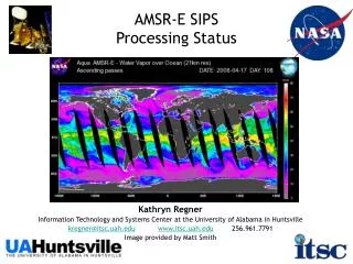
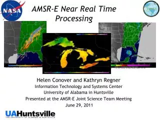
AMSR-E Near Real Time Processing. Helen Conover and Kathryn Regner Information Technology and Systems Center University of Alabama in Huntsville Presented at the AMSR-E Joint Science Team Meeting June 29, 2011. Outline. Overview: What is LANCE? Data Flow Hardware Configurations

E N D
AMSR-E Near Real Time Processing Helen Conover and Kathryn Regner Information Technology and Systems Center University of Alabama in Huntsville Presented at the AMSR-E Joint Science Team Meeting June 29, 2011
Outline • Overview: What is LANCE? • Data Flow • Hardware Configurations • Software Architecture • Users, Statistics, Outreach • Prototyping Efforts • Rapid Response Products • Direct Broadcast Investigation • Data Casting • Points of Contact
What is LANCE? • Land Atmosphere Near real-time Capability for EOS • provides access to near-real time (NRT) data products in less than 3 hours of the observation time. • supports a wide variety of applications users who are interested in monitoring natural and man-made hazards • LANCE products are freely available, but registration is required.
LANCE Central Term used to describe all of the instruments and distributed processing systems by the “LANCE Elements” GSFC Earth Sciences Data and Information Services Center MODIS (Moderate Resolution Imaging Spectroradiometer Adaptive Processing System Ozone Monitoring Instrument Science Investigator-led Processing System
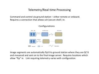
LANCE AMSR-E • System Highlights • Fully redundant strings of equipment in different locations on the UAHuntsville campus greatly reduce the likelihood of data unavailability due to system outage. • SIPS is using the same science algorithms running at the distributed processing sites, but with a direct input stream from NASA EDOS, minutes after downlink from the ground stations. • In addition to processing and distribution, the SIPS provides full data center support, including user services and documentation.
Move from GSFC to SIPS In March 2010, the AMSR-E SIPS was tasked to transition the AMSR-E processing from the MODAPS systems at GSFC to the SIPS in Huntsville. Work started in April. • First string of hardware began operations on September 27th • Redundant second string of equipment began operations on November 1st. • Both strings include • authentication via ESDIS User Registration System, • logging statistics into the ESDIS Metrics System, • local and LANCE-central web pages, • publicly accessible FTP servers and • data access via web interfaces and subscription service
SIPS Enhancements • Integration of Remote Sensing System’s (RSS) new Level-2A algorithm, designed and implemented specifically for near real-time processing • Our latest comparison study shows that AMSR-E brightness temperatures generated by the Land Atmosphere Near-real-time Capability for EOS (LANCE) system are quantitatively very close to brightness temperatures generated by the AMSR-E standard products generation system. The one week sample size evaluated shows that 99.7% of the values differed by 0.6K or less. The Level-2B rain products, as predicted, are almost identical (99.9% of the values differed by 0.2K or less). More information about the comparison can be found in the following document: lance.nsstc.nasa.gov/LANCE_AMSRE_Product_Evaluation_V5.docx
SIPS Enhancements (2) • In addition to Level-1 and Level-2 products generated previously at MODAPS, SIPS began generating Level-3 daily land, ocean, sea ice and snow • System Upgrades • Fully automated subscription service with failover • Generation of “incremental” or partial Level-3 daily files several times per day • Evaluating browse requirements specifically for near real time products
Software Architecture Near Real Time Ingest from EDOS Product Generation Scheduling ------------- On Demand ~ 29 times per day On Demand ~ 29 times per day Level-0 GBAD Ephemeris and Science Rate Buffered Data Level-1A Raw Observation Counts Level-1B Global Brightness Temperatures On Demand ~ 29 times per day On Demand ~ 29 times per day Multiple times per day Level-2A Global Swath Spatially-Resampled Brightness Temperatures L2B Ocean (1/2-orbit) L2B Rain (1/2-orbit) L2B Land (1/2-orbit) L3 Ocean (Daily) L3 Sea Ice (Daily, 3 Res) L3 Snow (Daily) L3 Land (Daily)
Product Distribution Summary Most recent three weeks. Information extracted from User Registration System (URS) Reports
Presentation • “Introducing NASA’s Near-real-time Processing Capability for Aqua AMSR-E, A Component of LANCE” poster presentation: • Earth Science Data Systems Working Group meeting in New Orleans, October 2010 • A-Train Symposium in New Orleans, October 2010 • 2010 Fall American Geophysical Union meeting in San Francisco, December 2010
Prototyping Efforts • Generation of select AMSR-E products for ingest into the LANCE (was MODIS) Rapid Response System http://lance.nasa.gov/imagery/rapid-response/ • AMSR-E Products and Use Cases • Rain Rate (severe storms and flood applications) • Snow Depth (land transportation applications) • Sea Ice Concentration (shipping and fishing applications) • Soil Moisture (drought and flooding applications)
Prototyping Efforts (2) • Direct Broadcast • Investigating the use of existing AMSR-E Level-1 code, without modification, to generate Level-2A products from Level-0 data received directly from satellite. • Data Casting • Investigating the use of GeoRSS data casting to enhance data discovery. http://datacasting.jpl.nasa.gov/
Points of Contact Staff shared with GHRC DAAC and AMSR-E SIPS Management: Dr. Sara Graves, Director, ITSC Team Leader: Helen Conover Software Engineering: Bruce Beaumont Metrics and Statistics: Mary Nair Systems Engineering: Kathryn Regner Hardware and Network Engineering: Sandra Harper User Services and Web Updates: Sherry Harrison Data Management: Lamar Hawkins Systems Administration: Will Ellett, Lead Michele Garrett, NSSTC Michael McEniry, TH
Backup Slides • Products