Download

1 / 29
290 likes | 443 Views
Simulated Stream Baseflow in the Nebraska Platte Basin due to Reduced Irrigated Land. Prepared by the Cooperative Hydrology Study (COHYST) for the Nebraska Department of Natural Resources (DNR) Draft of March 13, 2007. For internal COHYST use only. Outline of Presentation. Purpose

E N D
Simulated Stream Baseflow in the Nebraska Platte Basin due to Reduced Irrigated Land Prepared by the Cooperative Hydrology Study (COHYST) for the Nebraska Department of Natural Resources (DNR) Draft of March 13, 2007. For internal COHYST use only.
Outline of Presentation • Purpose • Area covered • Models used • Definitions • Meteorological data • Pumping effect • No pumping effect in HCA/OA
Outline (continued) • No pumping effect everywhere • Reduced pumping effect in HCA/OA • Reduced pumping effect everywhere
Purpose • Estimate effects of reduced groundwater irrigated land after 1997 on stream baseflows in Platte basin • Look at effects for 50 years • Look at effects for four reaches • Look at 20%, 40%, 60%, 80%, and 100% reductions in groundwater irrigated land • Results will be used by others to determine how to return to Fully Appropriated status
Area covered • Four areas • Wyoming line to Kingsley Dam • Kingsley Dam to Tri-County Supply Canal • Tri-County Supply Canal to Lexington • Lexington to U.S. Highway 183 • U.S. Highway 183 is eastern limit of Over Appropriated Area • Tributaries are counted where they enter the main stem
Models used • All models have 160 acre cells • Western model has one layer; Wyoming line to Kingsley Day • Central model has six layers; Kingsley Dam to Tri-County Supply Canal and Tri-County Supply Canal to Lexington • Eastern model has five layers; Lexington to U.S. Highway 183
Models used (continued) • Two stress period per year, May-September and October-April • Simulated period May 1998 through April 2048 • Models have different recharge rates on dryland and irrigated land • As irrigated land was reduced, the land was assumed to revert to dryland, and recharge was adjusted accordingly
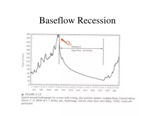
Definitions • HCA/OA – Hydrologically connected area of the over appropriated basin – administrative determination – legal consequences • Pumping Effect (PE) – changes in simulated stream baseflow after 1997 without any changes in 1997 land use. Formerly “lag effect” • No Pumping Effect (NPE) – changes in simulated stream baseflow after 1997 with elimination of pumpage for irrigation after 1997. Formerly “residual effect”
Definitions (continued) • Reduced Pumping Effect – changes in simulated stream baseflow after 1997 due to conversion of some groundwater irrigated land to dryland • In this presentation, irrigated land means groundwater irrigated land
Meteorological Data • Previous analyses used 1997 meteorological conditions. Caused concern to some • Present analysis determined if it is better to use historical (1950-97) meteorological conditions or average conditions • Future meteorological conditions may be different from 1950-97 conditions
Pumping effect • Wyoming line to Kingsley Dam • Average meteorological conditions
Pumping effect (cont.) • Wyoming line to Kingsley Dam • 1950-97 meteorological conditions
No pumping effect • Wyoming line to Kingsley Dam • No Pumping Effect in HCA/OA
NPE (continued) • Wyoming line to Kingsley Dam • No Pumping Effect everywhere
Selection of meteorological data • Needed to determine if selection of meteorological data substantially affected results • Previous graphs were not adequate to make the choice • Analysis of reduced irrigated land was done with 1950-97 and average meteorological data for Wyoming line to Kingsley Dam
Selection of met. data (cont.) • Technical committee chose to use average meteorological data because it was easier to see differences between curves • Choice was not unanimous and was contentious • May have made another choice if the difference between curves was not judged to be the most important thing to see in the analysis
Reduced pumping effect • Wyoming line to Kingsley Dam • Reduced irrigated land only in HCA/OA
Reduced pumping effect (cont.) • Kingsley Dam to Tri-County Supply Canal • Reduced irrigated land only in HCA/OA
Reduced pumping effect (cont.) • Tri-County Supply Canal to Lexington • Reduced irrigated land only in HCA/OA
Reduced pumping effect (cont.) • Lexington to U.S. Highway 183 • Reduced irrigated land only in HCA/OA
Reduced pumping effect (cont.) • Wyoming line to Kingsley Dam • Reduced irrigated land everywhere
Reduced pumping effect (cont.) • Kingsley Dam to Tri-County Supply Canal • Reduced irrigated land everywhere
Reduced pumping effect (cont.) • Tri-County Supply Canal to Lexington • Reduced irrigated land everywhere
Reduced pumping effect (cont.) • Lexington to U.S. Highway 183 • Reduced irrigated land everywhere
Closing comments • Analysis does not consider supplemental groundwater pumpage in surface-water irrigated areas • Future meteorological conditions may not reflect past meteorological conditions • Results more reliable in earlier time and less reliable in later time • Report in review and approval process