Download
1 / 25
250 likes | 419 Views
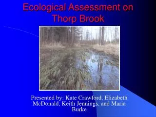
Ecological Assessment on Thorp Brook. Presented by: Kate Crawford, Elizabeth McDonald, Keith Jennings, and Maria Burke. Thorp Brook Watershed. Located in Charlotte, VT at the southern end of Chittenden County. Slightly west of Route 7. Approximately 1800 ha or 7 sq. miles

E N D
Ecological Assessment on Thorp Brook Presented by: Kate Crawford, Elizabeth McDonald, Keith Jennings, and Maria Burke
Thorp Brook Watershed • Located in Charlotte, VT at the southern end of Chittenden County. Slightly west of Route 7. • Approximately 1800 ha or 7 sq. miles • Flows into Lake Champlain
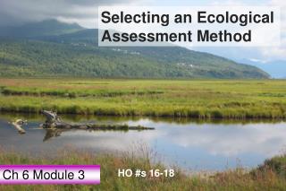
Thorp Brook • Located within the Lewis Creek watershed • Directly flows into Lake Champlain • Three main types of natural habitats • Valley Clayplain Forest • Lakeside Floodplain Forest • Wetland of Deep Bulrush marsh, Buttonbush swamp and Shallow Emergent marsh • Riverbed contains sand and gravel • Provides habitat to for six freshwater mussel species
Life Cycle of Freshwater Mussels The juvenile mussel will drop and spend years growing as an adult in the riverbed Adult mussels mate in summer/autumn Glochidia will attach to host fish and act as blood parasite
Pink Heelsplitter: Host fish could be the Freshwater drum Pocketbook: No known host species have been found Endangered Species
Threatened Species Giant floater: • Has 4 specific host species • Longnose gar • Blacknose dace • Blackchin shiner • Iowa darter
Benefits of Freshwater Mussels • Increases biodiversity • Purifies water as it takes up food with a siphon • Can store nutrients and toxins in shells • Great water quality indicator
Problem: Thorp Brook, which directly connects to Lake Champlain, will soon see an increase in residential development near its riverbanks Question: Are there alternative ways in reducing stormwater runoff to protect the endangered freshwater mussel species?
Goal Assess potential effects associated with excess storm water runoff in order to identify alternative ways in reducing storm water runoff to protect freshwater mussels Objective Assess how much additional storm water runoff will occur if residential development is constructed using TR55
GIS Methods • In order to obtain all of the data to be used by TR55 for the various development scenarios, several GIS processing steps had to be performed. • All of the data was collected from the Vermont Center for Geographic Information except for the ortho photos, which are from the UVM GIS drive.
GIS Methods • After all the data was collected, the main Thorp Brook watershed was delineated using the ArcHydro extension, which was also used to create the subwatersheds. • After the main watershed was created, the stream layer, the land use layer, and the soil layer were clipped to the watershed’s boundary.
GIS Methods • Using the Clip function in ArcMap, we were able to pare down the soils information for each subarea in order to determine the dominant hydrogroup. • Then the raster calculator function was used to obtain the landuse data for each of the subwatersheds. • All of the pertinent info was then plugged into TR55.
Subwatersheds • Divided into 6 subwatersheds based on stream reach delineation and soil classes. • Proposed development lies in Areas 4 and 5
Thorp Brook Soils • Soils in the main watershed are primarily in the D hydrogroup. • All soils in the proposed development are class D.
Thorp Brook Soils • Most areas in the watershed do not experience flooding, but there are some places near the proposed development that experience frequent and occasional flooding.
TR55 Analysis • Comparative hydrology between development scenarios • Four scenarios • Current • 21 ½-acre lots • 21 1-acre lots • 21 2-acre lots
Assumptions • Subarea Characteristics • Soil class of each subarea • Development lies within subarea 5 • Development converts pasture land to residential land • Channel Characteristics • Manning’s Roughness Coefficient = 0.02 • Bottom width = 4 m (Reach 6); 2 m (Reaches 2 & 5) • Average side slope = 5:1
Current Scenario • Six Subareas • Current landuse types • Normalized peak flow = 0.003 mm/s • Four scenarios identical • Explanation • 4% subarea 5 in question • CN’s only vary between 74 and 76
Localized Effects • 21 1-acre lots • 8.5 hectares • Normalized peak flow = 0.013 mm/s • 5-year storm
Findings • Negligible effect on Thorp Brook • Localized Impacts • Potential Negative Cumulative Effects
Potential Risks Associated with Development • Negative Effects on Mussels • Sedimentation • Decreased DO due to increased turbidity • Habitat Loss • Other Effects • Fish habitat • Geomorphology • Terrestrial habitat loss
Recommendations • During Construction • Maintain separation between construction and Thorp Brook • Install silt fences • Seasonal variations in soil stability could compound to yield increased sedimentation • General Recommendations • Leave 100-ft natural vegetation buffer • Stormwater management practices
Acknowledgements • Marty Illick, Lewis Creek Association • Erica Gaddis, ENSC 202 Instructor • Breck Bowden, ENSC 202 Instructor • Kevin Behm, Addison County Regional Planning Commission • Chet Hawkins, N. Ferrisberg Zoning Administrator