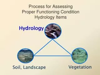
Process for Assessing Proper Functioning Condition Hydrology Items
Process for Assessing Proper Functioning Condition Hydrology Items. Hydrology. Vegetation. Soil, Landscape. Stability. Ability, over time, to transport water and sediment produced by the watershed maintaining dimension, pattern, and profile without aggrading or degrading.

Process for Assessing Proper Functioning Condition Hydrology Items
E N D
Presentation Transcript
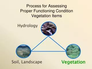
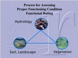
Process for Assessing Proper Functioning Condition Hydrology Items Hydrology Vegetation Soil, Landscape
Stability • Ability, over time, to transport water and sediment produced by the watershed • maintaining dimension, pattern, and profile • without aggrading or degrading
Stability = Rigidity maintaining dimension, pattern, and profile
Hydrology Items • Floodplain • Beaver Dams • Channel Characteristics • Riparian Area Widening • Watershed Influence Erosion Deposition Hydrology Vegetation Values
1) Floodplain above bankfull is inundated in “relatively frequent” events Purpose – determine whether frequent flood flows are capable of spreading out on a low-lying area adjacent to the stream and thus provide for • Energy dissipation • Sediment deposition • Periodic flooding of vegetation • Periodic infiltration of floodwaters
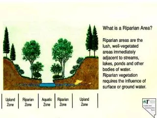
Definition: Floodplain • Level area near a stream channel • Constructed by the stream • In the present climate • Flooded during moderate & high flow events • Should not be confused with terraces (abandoned floodplains) (adapted from Leopold 1994) Item #1: Floodplain inundation
Floodplain • How much room does flood water have to spread out & reduce energy? • Temporary storage of water and sediments Item #1: Floodplain inundation
Definition: Bankfull • Flow that just fills the channel • Point where water just begins to overflow onto a floodplain • Recurrence interval of 1 to 3 years, 1.5 yr is considered a reasonable average Item #1: Floodplain inundation Verry et al. 2000
Why Bankfull is important Discharge at/near bankfull stage is the discharge at which channel maintenance is most effective in: • Moving sediment • Forming or removing bars • Forming bends • Doing work that results in the average morphologic characteristics (shape) of channels Item #1: Floodplain inundation Verry et al. 2000
Bankfull Stage Indicators Terrace Gaging station data • Deposition Features – Floodplain/Point bars • Changes in vegetation • Topographic break in slope • Change in size, staining, or color of substrate materials • Change in nature and amount of debris deposits (Leopold 1994) Bankfull Floodplain Item #1: Floodplain inundation
Examples of visual indicators at this site • 1983: Channel shape does not reflect a naturally stable channel within the valley type • Lack of well defined bankfull indicators Pearl Cr NV 1983 Pearl Cr NV 1982 Item #1 Floodplain inundation
1)Floodplain above bankfull is inundated in “relatively frequent” events • Examples of visual indicators that water has accessed the frequent floodplain • Sediment or debris deposition • Vegetation laid down by flow • Healthy riparian-wetland vegetation
2) Where beaver dams are present, they are active and stable Purpose • Document whether beaver dams are present, and if so, are being maintained • If not maintained or captured by vegetation, breaching can unleash tremendous energies
2) Where beaver dams are present, they are active and stable • Examples of visual indicators • Dam construction material • Dams keyed into streambanks • Breaches
2) Where beaver dams are present, they are active and stable • Examples of visual indicators • Riparian-wetland vegetation, especially shrubs growing on dam • Mud placed on dam, sediment deposition in pond • Organic matter accumulation in pond sediments • Macrophytes growing in pond
3) Sinuosity, width/depth ratio, and gradient are in balance with the landscape setting (i.e., landform, geology, and bioclimatic region) Purpose – document important roles in how well a stream dissipates energy • Three parts • sinuosity • width/depth ratio • gradient • all 3 must be “yes” for the answer to be “yes” • Near the shape & size expected for its setting Janes Meadow WY 1989 Janes Meadow WY 1997
3) Sinuosity, width/depth ratio, and gradient are in balance with the landscape setting (i.e., landform, geology, and bioclimatic region) • Examples of visual indicators • Aerial photos help with sinuosity
3) Sinuosity, width/depth ratio, and gradient are in balance with the landscape setting (i.e., landform, geology, and bioclimatic region) • Examples of visual indicators • Bank cutting on straight stretches between meanders (width) • False banks that keep eroding away
3) Sinuosity, width/depth ratio, and gradient are in balance with the landscape setting (i.e., landform, geology, and bioclimatic region) • Examples of visual indicators: • Excessive bank sloughing • Lack of defined streambank in moderate to low gradient streams (plate shape)
3) Sinuosity, width/depth ratio, and gradient are in balance with the landscape setting (i.e., landform, geology, and bioclimatic region) • Examples of visual indicators: • Overhanging banks • Stabilizing false banks
4) Riparian-wetland area is widening or has achieved potential extent Purpose – document that a riparian-wetland area is recovering or has recovered, which is expressed by an increase in riparian-wetland vegetation. • Sediment capture • Floodplain development • Flood-water retention • Increase of riparian-wetland vegetation
4) Riparian-wetland area is widening or has achieved potential extent • Widening, Enlarging = RIPARIAN AREA • Question has 2 parts • As the water table rises, riparian-wetland area can expand outward • As a stream channel narrows, riparian-wetland area expands toward the center of the channel • Or, has it reached potential extent?
4) Riparian-wetland area is widening or has achieved potential extent Widening, Enlarging = RIPARIAN AREAAs the water table rises, riparian-wetland area can expand outward Bully Creek OR 1982 Bully Creek OR 1988
4) Riparian-wetland area is widening or has achieved potential extent As a stream channel narrows, riparian-wetland area expands toward the center of the channel Bear Creek OR 1981 Bear Creek OR 1984
4) Riparian-wetland area is widening or has achieved potential extent • Examples of visual indicators • Riparian-wetland community types expanding • Upland plants dying or dead • Depositions being captured Fowl Manna Grass (Glyceria striata)
5) Upland watershed is not contributing to riparian degradation Purpose – document whether there has been a change in the water or sediment being supplied, and whether it is resulting in degradation
5) Upland watershed is not contributing to riparian degradation • Is there riparian-wetland degradation coming from the uplands • not contributing = “yes” • contributing = “no”
5) Upland watershed is not contributing to riparian degradation • Assess whether uplands are contributing to the degradation of a riparian-wetland area; not the condition of the uplands
5) Upland watershed is not contributing to riparian degradation
5) Upland watershed is not contributing to riparian degradation Belgo Cr BC 1996 Trapping Cr BC 1996
5) Upland watershed is not contributing to riparian degradation • Examples of visual indicators • Evidence of too much water, not enough water, too much sediment, not enough sediment
5) Upland watershed is not contributing to riparian degradation • Examples of visual indicators • Evidence of too much water, not enough water, too much sediment, not enough sediment Badger Cr, CO Badger Cr, CO
5) Upland watershed is not contributing to riparian degradation • Examples of visual indicators • Banks with healthy riparian-wetland vegetation with excessive cutting because of deposition • How main channel is handling tributary bedload inputs
Riparian-Wetland Attributes & Processes Vegetation Soil, Landscape Water