Download
1 / 1
10 likes | 126 Views
Maya ILIEVA 1,2,3 , Rana CHARARA 1,3 , Pierre BRIOLE 3 1 University “Pierre and Marie Curie” Paris – 6, France 2 Bulgarian Academy of sciences, Laboratory of geodesy, Sofia, Bulgaria 3 École Normale Supérieure, Laboratory of geology, Paris, France.

E N D
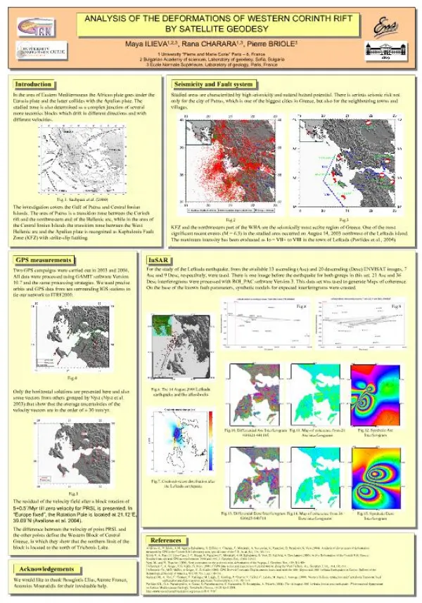
Maya ILIEVA1,2,3, Rana CHARARA1,3, Pierre BRIOLE3 1 University “Pierre and Marie Curie” Paris – 6, France 2 Bulgarian Academy of sciences, Laboratory of geodesy, Sofia, Bulgaria 3 École Normale Supérieure, Laboratory of geology, Paris, France ANALYSIS OF THE DEFORMATIONS OF WESTERN CORINTH RIFT BY SATELLITE GEODESY Introduction Seismicity and Fault system In the area of Eastern Mediterranean the African plate goes under the Eurasia plate and the latter collides with the Apulian plate. The studied zone is also determined as a complex junction of several more tectonics blocks which drift in different directions and with different velocities. Studied areas are characterized by high seismicity and natural hazard potential. There is serious seismic risk not only for the city of Patras, which is one of the biggest cities in Greece, but also for the neighbouring towns and villages. Fig.1. Sachpazi et al. (2000) The investigation covers the Gulf of Patras and Central Ionian Islands. The area of Patras is a transition zone between the Corinth rift and the northwestern end of the Hellenic arc, while in the area of the Central Ionian Islands the transition zone between the West Hellenic arc and the Apulian plate is recognized as Kephalonia Fault Zone (KFZ) with strike-slip faulting. Fig.2 Fig.3 KFZ and the northwestern part of the WHA are the seismically most active region of Greece. One of the most significant recent events (M = 6.3) in the studied area occurred on August 14, 2003 northwest of the Lefkada island. The maximum intensity has been evaluated as Io = VII+ to VIII in the town of Lefkada (Pavlides et al., 2004). GPS measurements InSAR For the study of the Lefkada earthquake, from the available 13 ascending (Asc) and 20 descending (Desc) ENVISAT images, 7 Asc and 9 Desc, respectively, were used. There is one image before the earthquake for both groups in this set. 21 Asc and 36 Desc interferograms were processed with ROI_PAC software Version 3. This data set was used to generate Maps of coherence. On the base of the known fault parameters, synthetic models for expected interferograms were created. Two GPS campaigns were carried out in 2003 and 2006, All data were processed using GAMIT software Version 10.7 and the same processing strategies. We used precise orbits and GPS data from ten surrounding IGS stations to tie our network to ITRF2000. Fig.8 Fig.9 Fig.4 Fig.6. The 14 August 2008 Lefkada earthquake and the aftershocks Only the horizontal solutions are presented here and also some vectors from others grouped by Nyst (Nyst et al. 2003) that show that the average uncertainties of the velocity vectors are in the order of ± 30 mm/yr. Fig.12. Synthetic Asc Interferogram Fig.10. Differential Asc Interferogram 030321-041105 Fig.11. Map of coherence from 21 Asc interferograms Fig.7. Coulomb stress distribution after the Lefkada earthquake Fig.5 The residual of the velocity field after a block rotation of 5+0.5˚/Myr till zero velocity for PRSL is presented. In “Europe fixed”, the Rotation Pole is located at 21.12˚E, 39.09˚N (Avallone et al. 2004). Fig.13. Differential Desc Interferogram 030625-040714 Fig.15. Synthetic Desc Interferogram Fig.14. Map of coherence from 36 Desc interferograms The difference between the velocity of point PRSL and the other points define the Western Block of Central Greece, in which they show that the northern limit of the block is located to the north of Trichonis Lake. References Avallone A., P. Briole, A.M. Agatza-Balodimou, H. Billiris, O. Charade, C. Mitsakaki, A. Nercessian, K. Papazissi, D. Paradissis, G. Veis (2004). Analysis of eleven years of deformation measured by GPS in the Corinth Rift Laboratory area, special issue of the C.R. Acad. Sci, 336, 301-311. Briole P., A. Rigo, H. Lyon-Caen, J.-C. Ruegg, K. Papazissi, C. Mitsakaki, A.M. Balodimou, G. Veis, D. Hatzfeld, A. Deschamps (2000). Active Deformation of the Corinth Rift, Greece: Results from repeated GPS surveys between 1990 and 1995, J. Geophys. Res, 25605-25625. Nyst, M., and W. Thatcher (2004), New constraints on the active tectonic deformation of the Aegean, J. Geophys. Res., 109, B11406 Hollenstein C, A. Geiger, H.G. Kahle, G. Veis ( 2006). CGPS time-series and trajectories of crustal motion along the West Hellenic Arc, Geophys. J. Int., 164, 182-191. Hollenstein Ch., M.D. Müller, A.Geiger, H.-G. Kahle (2008). GPS-Derived Coseismic Displacements Associated with the 2001 Skyros and 2003 Lefkada Earthquakes in Greece. Bulletin of the Seismological Society of America, Vol. 98, No. 1, pp. 149-161. Sachpazi M., A. Hirn, C. Clément, F. Haslinger, M. Laigle, E. Kissling, P. Charvis, Y. Hello,J.-C. Lépine, M. Sapin, J. Ansorge (2000). Western Hellenic subduction and CephaloniaTransorm: local earthquakes and plate transport and strain. Tectonophysics, 319, 301-319. Pavlides S.B., G.A. Papadopoulos, A. Ganas, G. Papathanassiou, V. Karastathis, D. Keramydas, A. Fokaefs (2004). The 14 August 2003 Lefkada (Ionian sea) earthquake. 5th International Symposium on Eastern Mediterranean Geology, Tessaloniki, Greece, 14-20 April 2004. http://www.openchannelfoundation.org/projects/ROI_PAC Acknowledgements We would like to thank Panagiotis Elias, Aurore Franco, Antonios Mouratidis for their invaluable help.