Download
1 / 39
390 likes | 434 Views
Explore advanced techniques in coastal oceanography for real-time sampling and forecasting of nearshore optical properties. Develop a data-assimilative model for coupled ocean-atmosphere forecasts. Join the open-access architecture for community involvement projects.

E N D
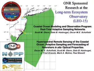
ONR SponsoredResearch at the Long-term Ecosystem Observatory (LEO-15) Coastal Ocean Modeling and Observation Program: Real-Time Adaptive Sampling Networks Scott M. Glenn, Dale B. Haidvogel, Oscar M.E. Schofield Hyperspectral Remote Sensing of the Coastal Ocean: Adaptive Sampling and Forecasting of Nearshore in situ Optical Properties Oscar M. E. Schofield, Scott M. Glenn, Dale B. Haidvogel, J. Fred Grassle, Mark A. Moline, Paul Bissett
NOPP ResearchProjects at the Long-term Ecosystem Observatory (LEO-15) 1998: Multi-Scale Model-Driven Sampling with Autonomous Systems at a National Littoral Laboratory J. Frederick Grassle, Scott M. Glenn, Dale B. Haidvogel, Christopher J. von Alt, Edward R. Levine, Donald E. Barrick, Belinda J. Lipa and Joel W. Young 1999: Demonstration of a Relocatable Regional Ocean/Atmosphere Modeling System with Coastal Autonomous Sampling Networks Scott M. Glenn, Dale B. Haidvogel, Roni Avissar, J. Frederick Grassle, Oscar M. E. Schofield, Christopher J. von Alt, Edward R. Levine, Douglas C. Webb, Donald E. Barrick, Belinda J. Lipa, Joel W. Young, Richard P. Signell
ONR/NOPP Objectives • Establish a National Littoral Laboratory • Deploy a Real-Time Multi-Disciplinary Coastal Ocean Observatory • Develop a Data-Assimilative Coupled Ocean-Atmosphere Coastal Forecast Model • Encourage Community Involvement Through an Open-Access Architecture
ONR/NOPP Objectives • Operate the System in a Continuing Series of Coastal Predictive Skill Experiments 1998 - Improve Nowcast Skill • Assimilation of remote sensing surface data, and • Shipboard/AUV adaptive sampling subsurface data 1999 - Improve Forecast Skill • Improved surface, bottom and lateral boundary conditions • New turbulent closure schemes • Physical/bio-optical adaptive sampling with ships and AUV’s
The Challenge “Shelf waters deeper than 3 meters and shallower than about 30 meters have often been ignored in the past because of the very difficult operating conditions and the complex dynamics, where the water is filled with turbulent boundary layers.” Ken H. Brink 12/12/97 Observational Coastal Oceanography National Science Foundation OCE Workshops http://www.joss.ucar.edu/joss_psg/project/oce_workshop
SODAR Met Buoy Optical Node Optical Vessel Webb Glider Freewave Communications Thermistor Strings Underwater Video
Regional Ocean Modeling System (ROMS) Development Initiated by Rutgers/UCLA 1997 Features: • Free-surface, hydrostatic, primitive equation model • State-of-the-art turbulence closure schemes for atmosphere and ocean • Efficient coarse-grained, shared-memory, parallel code • Enables support of high-resolution real-time coastal forecasting applications
Navy Products Rutgers Global Atmospheric Forecasts NOGAPS 1998 I.C. B.C. Local Atmospheric Forecasts NORAPS Atm. Forcing Ocean Models ROMS SBL
Navy Products NOAA & Rutgers Global Atmospheric Forecasts NOGAPS NCEP 1999 I.C. B.C. I.C. B.C. Local Atmospheric Forecasts COAMPS 27 km 6 hours RAMS 4 km 30 min Atm. Forcing Atm. Forcing Ocean Models ROMS PBL SBL BBL WBL MODAS (POM) I.C. B.C. Waves WAM Wave Models
Footnote Not a comparison of model physics. Navy Products NOAA & Rutgers Global Atmospheric Forecasts NOGAPS NCEP 1999 I.C. B.C. I.C. B.C. Local Atmospheric Forecasts COAMPS 27 km 6 hours RAMS 4 km 30 min Atm. Forcing Atm. Forcing Ocean Models ROMS PBL SBL BBL WBL MODAS (POM) I.C. B.C. Waves WAM Wave Models
RAMS Nested Grids Met Stations ROMSGrid 4 km 16 km
RAMS Surface Conditions VegetationCover SST
RAMS Forecast 40.00 18:00 19 Jul 99 85 of 145 Monday WindVectorsandAirTemp 36.67 77.03 71.11
Boundary Layer Schematic O H H L o n g w a v e Shortwave O E v a p H H
Model-Model Comparison The basic response with the two schemes is quite similar but .... • More intermediate density water is trapped at the coast with the Mellor-Yamada scheme. • The surface jet is approximately 10 cm/s weaker with the Mellor-Yamada scheme. Density Across-shore velocity Along-shore velocity LMD M-Y
BottomBoundaryLayerModel Ripple Height (m) - July 29, 1999 Sediment Concentration
July 14, 1999 - 15:00 GMT Temperature Cross Sections 25 23 21 19 17 15 13 11 0 5 10 15 20 25 Temp (oC) Depth (m) Observations 0 5 10 15 20 Distance (km) 25 23 21 19 17 15 13 11 25 23 21 19 17 15 13 11 0 5 10 15 20 25 0 5 10 15 20 25 Depth (m) Depth (m) Temp (oC) Temp (oC) RAMS Forcing COAMPS Forcing 0 5 10 15 20 0 5 10 15 20 Distance (km) Distance (km)
AVHRR SST July 28, 1999 08:00 GMT COAMPS Forcing July 28, 1999 21:00 GMT 28 26 24 22 20 18 16 14 12 10 39:42N 39:40N 39:30N 39:30N 39:20N 39:18N 39:10N 74:24W 74:12W 74:00W 73:48W 74:20W 74:10W 74:00W 73:50W Surface Currents and Temperature (oC)
AVHRR SST July 28, 1999 08:00 GMT MODAS/RAMS Forcing July 28, 1999 21:00 GMT 28 26 24 22 20 18 16 14 12 10 39:42N 39:40N 39:30N 39:30N 39:20N 39:18N 39:10N 74:24W 74:12W 74:00W 73:48W 74:20W 74:10W 74:00W 73:50W Surface Currents and Temperature (oC)
AVHRR SST July 28, 1999 08:00 GMT RAMS Forcing July 28, 1999 21:00 GMT 28 26 24 22 20 18 16 14 12 10 39:40N 39:40N 39:30N 39:30N 39:20N 39:20N 39:10N 39:10N 74:20W 74:10W 74:00W 73:50W 74:20W 74:10W 74:00W 73:50W Surface Currents and Temperature (oC)
ADCP Current Profile ROMS Current Profile Along Shore Cross Shore
Upper Layer Along Shore, Time-integrated Transport (July, 1999) 104*m2
July 23, 1998 - Detided Along Shelf Velocity Downshelf Transport 31.7 km3/s Downshelf Transport 29.4 km3/s Downshelf Transport 22.6 km3/s
m3/s *103 195 196 197 198 199 200 201 202 203 204 205 195 196 197 198 199 200 201 202 203 204 205 Instantaneous Along-Shore Transport North/South Integrated Cross-Shore Transport Surface/Bottom
Two Numbers equal to the volume of a semicircle of fluid 20m deep and a diameter of 15 nm If jet converges over a 50 km length scale it would provide the additional offshore transport observed at the offshore mooring. 2D Upwelling + Along-Shore Convergence = 3D Upwelling
9 7 5 3 1 Ekman Pumping (m/day) Cross-Shelf Time Integrated Transport 20 15 10 5 0 -5 Utop Ubot Tauy offshore 104 * m2 39:42N onshore 26 27 28 29 30 31 39:30N Along-Shelf Time Integrated Transport 25 15 5 -5 Vtop Vbot Taux North 39:18N 104 * m2 74:24W 74:12W 74:00W 73:48W South July 28, 1999 26 27 28 29 30 31
Conclusions • High spatial and temporal resolution RAMS produced better ocean forecasts than coarser COAMPS forcing • There is a need for a coupled, high-resolution ocean-atmosphere system that can be run locally in forecast mode • Initial conditions generated by continuousassimilation of CODAR produce better forecasts than cold starts using MODAS without CODAR assimilation • Offshore of the the upwelling center: • Forecasts indicate the upper layer offshore transport exceeds the Ekman transport • The bottom layer onshore transport does not fully compensate • Upwelling flow is 3-D with cold bottom water flowing in from the North
Acknowledgements Kristie Andreson Hernan Arango Trish Bergmann Bob Chant Jay Cullen Liz Creed Mike Crowley Scott Durski John Fracassi Joe Gryzmski Josh Kohut Sage Lichtenwalner Mark Moline Chris Orrico Hai Pan Rich Styles Sasha Tozzi Jess Vanisko John Wiggins
Bottom Layer Along Shore, Time-integrated Transport (July, 1999) 104*m2