Download
1 / 44
440 likes | 513 Views
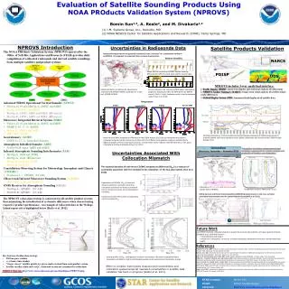
Validation results of the NWCSAF/MSG Clear Air Products. Gabriela Cuevas Tascón, INM (Spain). November, 28th CDOP NWCSAF Workshop on Physical Retrieval. OVERVIEW. GENERAL OBJECTIVES METHODOLOGY OUTLINE VALIDATION DATASETS: ECMWF ANALYSIS FIELDS RADIOSONDE DATA

E N D
Validation results of the NWCSAF/MSG Clear Air Products Gabriela Cuevas Tascón, INM (Spain) November, 28th CDOP NWCSAF Workshop on Physical Retrieval CDOP NWC SAF Workshop on Physical Retrieval
OVERVIEW • GENERAL OBJECTIVES • METHODOLOGY OUTLINE • VALIDATION DATASETS: • ECMWF ANALYSIS FIELDS • RADIOSONDE DATA • INTEGRATED WATER VAPOR from GPS • VALIDATION • CONCLUSIONS • IN PERSPECTIVE CDOP NWC SAF Workshop on Physical Retrieval
GENERAL OBJECTIVES • Extensive validation of the precipitable water in three layers (sfc-840hPa, 840hPa-437hPa and 437hPa-top) and in the total column together with the lifted index. • Estimation of the quality and spatial behavior of each clear air parameter. • All parameters are validated using a long period (at least one year) =>all seasons are included. • Comparison with the previous version 1.3 output: improvements. • The parameters are validated using the MSG-Nregion => different geographical areas and various atmospheric conditions are considered. • Analysis of the areas with worst performances=> future algorithm improvements. CDOP NWC SAF Workshop on Physical Retrieval
METHODOLOGY OUTLINE • According to last NWCSAF Steering Group Meeting (CDOP-SG01) => Delivery 2008: • PGE06 version 3.0 (TPW): the usual PGE06 product has been replaced by the former 4th PGE07 output (TPW control obtained with neural networks). • PGE07 version 2.0 (LPW): 3 outputs (boundary, middle and high layers). • PGE08 version 2.0(SAI-LI): 1 output (lifted index) • Testing of the improvements in the delivery 2008 (including the radiance local bias correction and the parameter local adjustment). Following criteria: • PGE06 v3.0 versus the fourth output of PGE07 v1.3. • PGE07 v2.0 versus the three layers of PGE07 v1.3. • PGE08 v2.0 versus PGE08 v1.3. • An intermediary version product will be presented, hereafter the “improved v1.3” which includes only the radiance local bias correction (before the parameter local adjustment). CDOP NWC SAF Workshop on Physical Retrieval
METHODOLOGY OUTLINE • Period: July 2005-December 2006 (at 00 and 12 UTC) : • Cloud mask (SAFNWC CMa): reprocessing of versionv1. 3 using ECMWF analyses as inputs (instead of NWP forecasts) • Reprocessing of clear air SAFNWC products (for the 3 versions) • Validation over pixels classified as clear (no additional constraints) • Collocation of all validating data with the SAFNWC parameter data using McIDAS; reading of the SAFNWC HDF-5 files and calculation of statistical parameters with IDL routines. • Exclusion of desert pixels (non-realistic results). • All the ECMWF datasets used on the tuning of the algorithms (neural networks, bias calculation, etc) cover temporal periods totally different to the ECMWF validation period. CDOP NWC SAF Workshop on Physical Retrieval
VALIDATION DATASET • ECMWF ANALYSIS FIELDS • Download of quantitative analyses from July 2005 to June 2006 (00 and 12 UTC) from MARS/ECMWF. • The region is defined by the corners (70ºN, 40ºW) and (28ºN, 40ºE), with a grid step of 0.5º. • The ECMWF parameters have been remapped to SEVIRI projection using McIDAS and IDL routines. • One every ten has been extracted to build the validation dataset and only zenith angles lower than 70º are considered. • Desert pixels excluded in the validation (non-realistic results) : differentiation of desert and non desert pixels done through the Global Land Cover-LANDSAF/MSG group of the Valencia University (25 classes of land cover, among which “bare areas” includes desert areas) CDOP NWC SAF Workshop on Physical Retrieval
VALIDATION DATASET • RADIOSONDE DATA • Use of radiosonde profiles from 102 RAOB stations over MSG-N region for the period of 1st July 2005-31st December 2006 at 00 and 12 UTC (provided by the University of Wyoming). • The stations over desert areas have been removed through the desert mask (Valencia University). Stations covered by a significant zenith angle (<70º) over the MSG-N region CDOP NWC SAF Workshop on Physical Retrieval
VALIDATION DATASET • INTEGRATED WATER VAPOR from GPS • European Network of Global Positioning System (GPS) ground-based receivers are routinely used to provide near-real-time estimations of precipitable water vapor => another independent water vapour measurement source. • Comparison with GPS data for 1-year period (1st May 2005- 30th April 2006) from the 178 GPS sites of two processing centres (GFZ and METO). • Most independent and reliable validation source in this study. CDOP NWC SAF Workshop on Physical Retrieval
1.VALIDATION WITH ECMWF CDOP NWC SAF Workshop on Physical Retrieval
VALIDATION OVER SEA PIXELS The scatter plots displayed on the next slides show the BL, ML, HL, TPW and LI parameters from ECMWF analysis data versus the SEVIRI PW and SAI parameters (TPW, LPW_BL, LPW_ML, LPW_HL and SAI_LI) for the period 1stJuly 2005-31st June 2006 at 00 and 12 UTC over sea pixels. 0 128 256 385 513 642 Number of pixels used in validation=>Few clear air days over the North Atlantic (bad representation reflected on the statistical parameters) CDOP NWC SAF Workshop on Physical Retrieval
TPW over sea pixels Increasing 0.06 Decreasing 0.85 CDOP NWC SAF Workshop on Physical Retrieval
LPW_BL over sea pixels Increasing 0.06 Decreasing 0.27 CDOP NWC SAF Workshop on Physical Retrieval
LPW_ML over sea pixels Increasing 0.06 Decreasing 0.61 CDOP NWC SAF Workshop on Physical Retrieval
LPW_HL over sea pixels Increasing 0.03 Decreasing 0.30 CDOP NWC SAF Workshop on Physical Retrieval
SAI_LI over sea pixels Increasing 0.08ºC Decreasing 1.9ºC CDOP NWC SAF Workshop on Physical Retrieval
SPATIAL DISTRIBUTION (over sea) TPW BIAS • Bias reduction for the latest version over the whole region, especially in the Baltic area. • Bad performances over the North Atlantic, probably associated to the lack of clear air pixels over this area => detailed analysis in perspective. • Similar results are obtained for the rest of the LPW (BL, ML, HL) and SAI parameters. CDOP NWC SAF Workshop on Physical Retrieval
SPATIAL DISTRIBUTION (over sea) TPW CORRELATION COEFFICIENT (ECMWF vs SAFNWC v1.3) (ECMWF vs SAFNWC v3.0) SAFNWC TPW versus ECMWF analysis TPW correlation coefficient increases: more red and yellow pixels are found in the latest version v3.0 (yellow maximum correlation). TPW RMS ERROR (mm) B A The rms error coefficient decreases: more red and yellow pixels are found in the latest version 3.0 (yellow minimum rms error). Areas “A” and “B” represent the highest rmse values: area “A” also has low correlation and area “B” is associated with the highest bias. CDOP NWC SAF Workshop on Physical Retrieval
LPW_BL RMSE (mm) (ECMWF vs SAFNWC v1.3) (ECMWF vs SAFNWC v2.0) LPW_ML RMSE (mm) LPW_HL RMSE (mm) CDOP NWC SAF Workshop on Physical Retrieval
SPATIAL DISTRIBUTION (over sea) SAI_LI RMS ERROR (ºC) (ECMWF vs SAFNWC v1.3) (ECMWF vs SAFNWC v2.0) 7.0 6.0 5.0 4.0 3.0 2.0 7.0 6.0 5.0 4.0 3.0 2.0 • The rms error coefficient significantly decreases in version 2.0 => • Careful analysis required on the coastal areas colored in green. • The correlation coefficient increases but not enough => necessary improvement of this parameter. CDOP NWC SAF Workshop on Physical Retrieval
VALIDATION OVER NON-DESERT LAND PIXELS The scatter plots displayed on the next slides show the BL, ML, HL, TPW and LI parameters from ECMWF analysis data versus the SEVIRI TPW, LPW and SAI parameters for the period 1stJuly 2005-31st June 2006 (at 00 and 12 UTC) over non-desert land pixels. Number of pixels used in validation=> few clear air days found over North Europe CDOP NWC SAF Workshop on Physical Retrieval
TPW over non-desert land pixels Increasing 0.05 Decreasing 1.02 CDOP NWC SAF Workshop on Physical Retrieval
LPW_BL over non-desert land pixels Increasing 0.04 Decreasing 0.48 CDOP NWC SAF Workshop on Physical Retrieval
LPW_ML over non-desert land pixels Increasing 0.11 Decreasing 0.88 CDOP NWC SAF Workshop on Physical Retrieval
LPW_HL over non-desert land pixels Increasing 0.13 Decreasing 0.12 CDOP NWC SAF Workshop on Physical Retrieval
SAI_LI over non-desert land pixels Increasing 0.15º Decreasing 0.63º CDOP NWC SAF Workshop on Physical Retrieval
SPATIAL DISTRIBUTION (over non-desert land) TPW BIAS • Bias reduction for the latest version v3.0 over the whole region, especially in North Europe. • Poor behaviour observed over few pixels (blue and yellow): they are being carefully checked in order to know the reasons of this. • Similar results are obtained for the rest of the LPW (BL, ML, HL) and SAI parameters. CDOP NWC SAF Workshop on Physical Retrieval
SPATIAL DISTRIBUTION (over non desert land) TPW CORRELATION COEFFICIENT (ECMWF vs SAFNWC v1.3) (ECMWF vs SAFNWC v3.0) Correlation coefficient increases: pixels tend to be a bit more yellow over Central Europe. TPW RMS ERROR (mm) The rms error coefficient decreases: more red and yellow pixels are found in the latest version 3.0 (yellow minimum rms error). Rms error and correlation values in North Europe are comparable to the ones over the Spanish region for v3.0 (requirement of the past ‘ Product Assessment Review Workshop’ in Madrid, October 2005). CDOP NWC SAF Workshop on Physical Retrieval
LPW_BL RMSE (mm) (ECMWF vs SAFNWC v1.3) (ECMWF vs SAFNWC v2.0) LPW_ML RMSE (mm) LPW_HL RMSE (mm) CDOP NWC SAF Workshop on Physical Retrieval
SPATIAL DISTRIBUTION (over non desert land) SAI_LI RMS ERROR (ºC) (ECMWF vs SAFNWC v1.3) (ECMWF vs SAFNWC v2.0) 7.0 6.0 5.0 4.0 3.0 2.0 7.0 6.0 5.0 4.0 3.0 2.0 • The rms error coefficient significantly decreases in version 2.0 => • More detailed analysis is required for the regions still colored in green. • Future improvements are still necessary on this parameter. CDOP NWC SAF Workshop on Physical Retrieval
2. RADIOSOUNDING COMPARISON CDOP NWC SAF Workshop on Physical Retrieval
VALIDATION with RADIOSONDES: non-desert. • Number of pixels used in the validation: • Collocation of both databases (only stations with more than 12 matches have been included) • Stations from North Europe present less clear air days than the southern ones. • Stations over desert areas have been removed (use of desert mask). The scatter plots displayed next show the comparison of the SEVIRI TPW, LPW(LPW_BL, LPW_ML, LPW_HL) and SAI_LI parameters versus the equivalent parameters from radiosounding profiles for the period of 1st July 2005-31st December 2006 at 00 and 12 UTC. The improvements in TPW,LPW and SAI parameters on the latest version (delivery 2008) are significant for all parameters: correlation coefficients increases and the rms error decreases in all parameters. CDOP NWC SAF Workshop on Physical Retrieval
VALIDATION with RADIOSONDES : TPW Increasing 0.01 Decreasing 0.59 V1.3 V3.0 CDOP NWC SAF Workshop on Physical Retrieval
VALIDATION with RADIOSONDES : TPW V1.3 V3.0 • Spatial behaviour of rms errors between SAF_TPW and radiosonde TPW: • Most significant improvements located over North and Central Europe, as it was already observed in the comparison between SAFNWC TPW and ECMWF TPW. • Results corroborated by the spatial distribution of correlation coefficient. CDOP NWC SAF Workshop on Physical Retrieval
VALIDATION with RADIOSONDES : LPW_BL V1.3 V2.0 CDOP NWC SAF Workshop on Physical Retrieval
VALIDATION with RADIOSONDES : LPW_ML Increasing 0.06 Decreasing 0.67 V1.3 V2.0 CDOP NWC SAF Workshop on Physical Retrieval
VALIDATION with RADIOSONDES : LPW_HL Decreasing 0.25 V1.3 V2.0 CDOP NWC SAF Workshop on Physical Retrieval
RADIOSONDE VALIDATION : spatial distribution V1.3 V2.0 • Spatial behaviour of rms errors between SAF LPW_ML and radiosonde ML: • Best improvements over Central and North Europe (reduction of rmse): more significant for the middle layer ML. • Results corroborated by the spatial distribution of correlation coefficient. • Bad behaviour for the HL probably associated to the bad representation of the humidity at the high troposphere on the radiosonde profiles => inclusion of a flag in the calculus of HL for the radiosonde in perspective. CDOP NWC SAF Workshop on Physical Retrieval
3. COMPARISON with GPS CDOP NWC SAF Workshop on Physical Retrieval
COMPARISON with GPS Decreasing 0.35mm Decreasing 0.8mm • Considerable improvements achieved with the new correction (v3.0) for both processing centers. • Best agreement at GFZ center: • Possible impact of the lack of clear-air pixels, suspect decontaminations for UK area. • Different IWV extraction algorithms for each center. • 2D-histograms shown next: the LPW_TPW v1.3 was systematically wetter => this problem is corrected in the new version. CDOP NWC SAF Workshop on Physical Retrieval
COMPARISON with GPS SAFNWC versus GFZ centre V1.3 V3.0 SAFNWC versus METO centre V1.3 V3.0 CDOP NWC SAF Workshop on Physical Retrieval
COMPARISON with GPS V1.3 V3.0 • Very good results over GFZ stations (rmse below 4.0). • GFZ database very reliable (optimal algorithm results) => sign of SAFNWC TPW accuracy over German region. CDOP NWC SAF Workshop on Physical Retrieval
CONCLUSIONS • The 2D-histograms and statistical parameters show that the parameter accuracy increases when the local bias correction is applied (delivery 2008): • ECMWF: a general increase of correlation is observed as well as a reduction of rms error over both (sea and non-desert land pixels) when the are analysed, especially over North-Europe and over North and Baltic seas. • Radiosonde: similar results are found, being the rms errors over North and Central Europe comparable to those over the Peninsula (requirement of the Product Assessment Review Workshop in 2005). • GPS IWV: it also supports the previous results. Improvements for the latest version in both processing centres (GFZ and METO). • A slight tendency to negative biases is highlighted: overcorrection of radiances at some points. • Poor performance at some pixels (low correlation, high rmse) => further check. • The bias radiance correction has a positive impact in the LI parameter. • The quality of lifted index (SAI parameter) is not as good as for the precipitable water parameters, especially for very stable cases (LI >8ºC).Still, trends of the LI are useful for forecasters (case studies, image loops) • It is not adequate to use this algorithm over desert pixels yet. CDOP NWC SAF Workshop on Physical Retrieval
IN PERSPECTIVE • Other sources will be introduced in the comparison process in order to achieve a better assessment the quality. • Desert areas and their associated emissivity problems need to be carefully analysed in future works. This may be done with the help of other data sources as IASI, atlas emissivities, etc. • To improve the validation databases: • Including flags with different altitudes (SEVIRI pixel, ECMWF grib-cell and radiosonde in the corresponding database) • Introducing other techniques to collocate databases with different spatial resolution. • A more detailed analysis is being kept for radiosonde database (station by station) • High influence of the boundary layer on the coded lifted index => other instability indices without this influence will be coded to use together with LI (Showalter stability index, K-index) • The radiance definition change planned by EUMETSAT in 2008 should not modify significantly the results presented here, because this change has been taken into account as a correction in the algorithm. CDOP NWC SAF Workshop on Physical Retrieval
THANKS FOR YOUR ATTENTION CDOP NWC SAF Workshop on Physical Retrieval