Download
1 / 42
440 likes | 774 Views
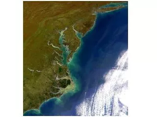
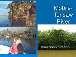
Mobile-Tensaw River Delta. MOBILE-TENSAW RIVER DELTA. Location. The Mobile-Tensaw River Delta is the second largest river delta in the U.S., second only to the Mississippi River Delta. It is characterized by many distributary rivers, streams, bayous and creeks which form a maze of waterways.

E N D
Mobile-Tensaw River Delta MOBILE-TENSAW RIVER DELTA
Location • The Mobile-Tensaw River Delta is the second largest river delta in the U.S., second only to the Mississippi River Delta. • It is characterized by many distributary rivers, streams, bayous and creeks which form a maze of waterways. • The Delta itself covers over 400 square miles or 300,000 acres of swamps, marshes, and river bottomlands that are among the most impressive in the world, so impressive that Congress recently named the Delta a National Natural Landmark. Mobile Causeway/Bayway
Unique Shape • The Mobile-Tensaw is an elongated delta formed, some experts say, as a result of a depression or sinking of the earth between two geological faults. • Thus, the Mobile-Tensaw Delta is bounded on both sides by relatively high ground.
Wetland Habitat • The Mobile-Tensaw River Delta is one of the largest intact wetland ecosystems in the United States. • Overall, it comprises approximately 260,000 acres of wetland habitats, ranging from submersed grass beds to cypress-gum swamps and seasonally flooded bottomland hardwoods
Northern Delta- Bottomland Hardwoods • Over 36,000 acres of the most extensive area of seasonally flooded bottomland hardwoods in Alabama. • Here you can see swamp forests of bald cypress and tupelo gum trees.
Note the cypress “knees”—the remnants of cypress trees that once dotted the shore. Also note the triangular-shaped bases of the knees. These are buttress trunks that enable the trees to stand along the shoreline.
Moving South- River Swamp Forest • River swamp forest, or deepwater alluvial swamp, which naturally supports bald cypress and water tupelo in equal numbers. • Common shrubs include common alder, buttonbush, swamp privet, fetterbush, and black willow. • Typical herbs include golden club, swamp lily, and fragrant water lilies. Spanish moss is a common epiphyte growing among the crowns of trees. • These habitats can easily be seen from the I-65 bridge that dissects the Delta north of Mobile.
Moving South- Lower Hardwood Swamp Forest • Lower hardwood swamp forest, sometimes referred to as the first bottom, is characterized by a greater diversity of woody species. • These include overcup and laurel oak, water hickory, river birch, red maple, and green ash, as well as cottonwood in disturbed areas. Non-woody plants include lizard’s tail, jewelweed, and several species of ferns.
Continuing further downstream, a maze of bayous, creeks, distributary channels and other watercourses bisect the Delta between the Tensaw River and Big Lizard Creek adding to the hydrologic and ecologic diversity of the system.
Tidal Freshwater Marsh • Tidal freshwater marshes occur in the extreme lower portion of the Delta near the mouth of Mobile Bay.
Importance of the Delta • The Delta does things for us: • It's a water filter, a sponge during hurricanes and floods. • It also serves as a nursery for redfish, menhaden, white shrimp and numerous other species caught commercially in the Gulf. • Indeed, the Delta is an indispensable partner to the Gulf, which accounts for more than 35 percent of the nation's commercial seafood catch.
What is an Estuary? • Estuary (es-choo-er-ee) - a partially enclosed coastal body of water, having an open connection with the ocean, where freshwater from inland (Mobile-Tensaw River Delta) is mixed with saltwater from the Gulf of Mexico. • Estuaries represent some of the most sensitive and ecologically important habitats on earth. • They provide sanctuary for many species of waterfowl, store nutrients for larval and juvenile marine life, and serve as breeding grounds for many desirable species of ocean fish.
Importance of an Estuary • The estuary is considered environmentally and economically important because of its exceptional biological diversity and productivity. • It supports both fresh and saltwater species and serves as nursery habitat for many commercially and recreationally important species.
Mobile Bay National Estuary Program • The United States Environmental Protection Agency's (EPA's) National Estuary Program (NEP) was established by Congress in 1987 to improve the quality of estuaries of national importance. • The mission of the MBNEP is to promote wise stewardship of the water quality characteristics and living resource base of the Mobile Bay estuarine system.
The Mobile Bay NEP area of study includes both Baldwin and Mobile Counties which surround Mobile Bay, the Mississippi Sound westward to the Alabama-Mississippi State Line, and the Alabama State marine waters in the north central Gulf of Mexico, extending three miles south of Dauphin Island and the Fort Morgan Peninsula. .
Mobile Bay National Estuary Program Priorities • Water Quality • Living Resources • Habitat Management • Human Uses • Education & Public Involvement.
Scientific Monitoring • Atmospheric Monitoring: Each of these stations monitor temperature, humidity, wind speed wind direction and precipitation. • Hydrographic Monitoring (water): water temperature, salinity (amount of salt in the water), oxygen levels, tide height, nutrients and other information on the water.
Human Impact • Human impact on estuaries includes reclamation of tidal land by: • filling • pollution from sewage • solid waste • increased sedimentation filling the estuary • alteration of the salinity of estuarine waters by withdrawal or increased influx of freshwater.
Weeks Bay Estuary • The Weeks Bay Foundation was incorporated in 1990 as a to support the Weeks Bay National Estuarine Research Reserve in its efforts to protect the pristine coastal area of Baldwin County , Alabama . • The Foundation supports the Reserve through donations of land and educational exhibits, public awareness and education programs, water quality monitoring efforts, and volunteer programs.
Location The Weeks Bay Watershed has a drainage area of almost 126,000 acres (approximately 200 square miles) in Baldwin County.
Pitcher Plants Abound, Making Weeks Bay a Tourist Attraction
The Endangered Alabama Red-Bellied Turtle: Not just anyone can hold one; you must have a permit to handle these animals. Watch out for them as you cross the Causeway.