Download
1 / 29
290 likes | 376 Views
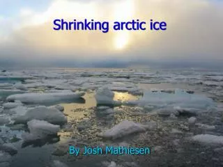
Discussion about two papers concerning the changing Arctic sea ice. GEO6011Seminar in Geospatial Science and Applications Wentao Xia 11/19/2012. Bering Strait. Alaska. Chukchi Sea. Eastern Siberian Sea. Beaufort Sea. Canada. Russia. Laptev Sea. Canadian Archipelago. Arctic Ocean.

E N D
Discussion about two papers concerning the changing Arctic sea ice GEO6011Seminar in Geospatial Science and Applications Wentao Xia 11/19/2012
Bering Strait Alaska Chukchi Sea Eastern Siberian Sea Beaufort Sea Canada Russia Laptev Sea Canadian Archipelago Arctic Ocean Fury and Hecla Strait Kara Sea Hudson Bay Baffin Bay Svalbard Greenland Barents Sea Greenland Sea Gorlo Strait White Sea
Discussion to Arctic sea ice variability and trends, 1979-2010 Cavalieri D. and Parkinson C. (2012) The Cryosphere, 6, 881-889
Data and method What data does this study used? • SMMR-Nimbus 7 (10/26/1978-08/20/1987) • SSM/I-DMSP F8,F11,F13 (07/09/1987-12/31/2007) • SSM/IS-DMSP F17 (01/01/2008-present)
Technical specifications SMMR-Nimbus 7: Operating frequency: 6.60 GHz H/V, 10.69 GHz H/V, 18.00 GHz H/V, 21.00 GHz H/V and 37.00 GHz H/V Spatial, temporal, and radiometric resolution: 25 km*25km, 2 days, 16-bit
Technical specifications SSM/I – DMSP: Operating frequency and corresponding spatial resolution (along track*cross track / meters): 19.35 GHz H/V 69*43, 22.235 GHz V 50*40, 37.00 GHz H/V 37*28 85.50 GHz H/V 15*13
Technical specifications SSM/IS – DMSP: Operating frequency and corresponding spatial resolution (along track*cross track / meters): 19.35 GHz H/V 73*47, 22.235 GHz V 73*47, 37.00 GHz H/V 41*31 From 50.3 to 60.72 GHz (13 bands) 17.6*27.3 91.665 GHz H/V 14*13 150 GHz 14*13 183.311 GHz (2 bands) 14*13
Data and method • Sea ice concentration: Matching different passive microwave record at geophysical product level • Sea ice extent: Area with ≥15% ice concentration (Atmospheric interference, low ice concentration, thin ice thickness) How sea ice extent is defined? Why?
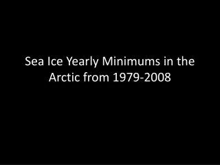
Trend of ice extent in three periods:1979-1996, 1979-2006, 1979-2010
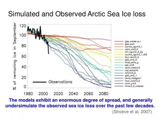
Conclusion and further discussion What trend does northern hemisphere sea ice extent variation have? • Northern hemisphere ice extent variability showed a declining trend. • Trend is mostly pronounced in Arctic Ocean, and in summer. • Trend of declining rapidly increased during last decade. When and where the trend is strongest? What change does such trend have in recent years?
Discussion to The changing Arctic sea ice cover by Perovich D. (2011) Oceanography 24(3):162-173
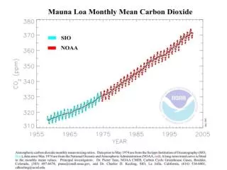
Monthly northern hemisphere sea ice extent by passive microwave
September ice extent abnormal -12.8%/decade Standard deviation=1.6%
Ice age • First year ice survived through next September minimum is counted as multiyear ice. • Observation: Active microwave remote sensing and ice parcels tracking. • Difference: Multiyear ice tend to be thicker and more resilient to environmental forcing. How multiyear ice defined? How to observe ice age? What is the most important different between first and multi year ice?
Ice thickness • Related to ice age, proxy. • Field observation: with submersed upward looking sonar onboard nuclear submarine • Remote sensing: satellite altimetry • Lacking continuous pan Arctic sea ice thickness record Is there continuous sea ice thickness data record in Arctic?
Explanation to 2007 extreme event • Preconditioning: loss of multiyear ice, decreasing of ice thickness • Advection of ocean heat through Bering Strait • Trans-Arctic drift to Fram Strait, and warm air inflow from Pacific by wind forcing • Ice-Albedo feedback What is ice albedo feedback? • Decrease in cloudiness – more impact on open water-warmer water-more bottom and lateral melting
Linear trend of total solar heat input directly into the ocean, percent/year
Air and water temperature dynamics by buoy deployed at Beaufort Sea, Aug 2006 - Sep 2007
Conclusion from two presented papers What contribute most to the accelerating declining trend of Arctic sea ice extent, statistically? • Ice extent: Declining trend - mostly due to recent extreme summer minimum extent • Ice age and thickness: Declining - due to climate change • contributing to preconditioning • Extreme low summer minimum extent: • triggered by environmental forcing • triggers ice-albedo feedback • further enhancing preconditioning What is the relationship between the declining ice age/thickness and ice extnet? What role does ice-albedo feedback played in the process of sea ice declining?