Download
1 / 14
140 likes | 305 Views
NG911 GIS User Group. NG911 GIS User Group. Led by GIS Committee Quarterly (or as needed) conference calls Meeting/social at annual KAM Conference Purpose: Outreach and coordination effort to discuss and update users on NG911 GIS related project topics

E N D
NG911 GIS User Group Led by GIS Committee Quarterly (or as needed) conference calls Meeting/social at annual KAM Conference Purpose: Outreach and coordination effort to discuss and update users on NG911 GIS related project topics NG911 Data Stewards & Data Maintainers Portal: Documents, presentations, email list, etc. DASC NG911 webpage: GIS related content, announcements, training registration, etc.
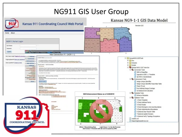
GIS Data Remediation Started in 2014 Completed September, 2016! All 117 PSAPs passed Final QA 100% compliance with Kansas NG911 GIS Data Model NG911 Statewide Over 1.3 million address points 471,033 road segments NG911 GIS User Group
NG911 Portal and GIS Data Maintenance GIS Data Maintenance Submit GIS data updates on the NG911 Portal Frequency As needed Quarterly (minimum) Submission statistics Over 300 submission First submission Oct 13, 2015
Please keep contact information current • View history of GIS submissions • Documents > GIS NG911 Portal
How the KS NG911 Program Works County A NG911 Portal Vesta Locate Updated Data County B Master Repository Updated Data County C
Kansas NG911 Hosted Solution 38 PSAPs/Counties on hosted solution
What is Vesta Locate? • Kansas NG911 Hosted Solution map interface for call handling • Includes a map that receives GIS data from a central server • Local or Central Map Administration • Part of Statewide 911 phone system • Over 70 counties have signed up and installations are progressing continually
Monthly updates • Email updates will start coming from to Portal (portal@kansas911.org) • Official Change Log on GitHub • https://github.com/kansasgis/NG911/commits/master NG911 Toolbox • Coming soon - October • MSAG comparison tool • Data Model v1.1 to v2.0 conversion tool
DASC NG911 webpage http://www.kansasgis.org/initiatives/NG911 • Kansas NG9-1-1 GIS Data Model v2.0 • Kansas NG9-1-1 GIS Data Model Domains v2.0 • Training announcements • Local GIS Data Steward and GIS Data Maintainer offered annually in all 6 regions • On-line “continuing ed” training • Imagery • GIS Committee discussing NG911 Imagery refresh plans with 911 Council