Download
1 / 51
520 likes | 948 Views
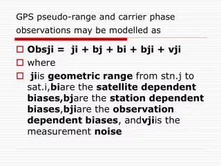
GPS pseudo-range and carrier phase observations may be modelled as. Obsji = ji + bj + bi + bji + vji where

E N D
GPS pseudo-range and carrier phase observations may be modelled as • Obsji = ji + bj + bi + bji + vji • where • jiis geometric range from stn.j to sat.i,biare the satellite dependent biases,bjare the station dependent biases,bjiare the observation dependent biases, andvjiis the measurement noise
sample data file record for one epoch (date 26/7/92, time 6:52:30 UT) to the five satellites PRN2, 11, 18, 19, 28 (one record of five observation data types to each satellite) will help illustrate the impact of some of the measurement biases and errors:
C/A pseudo-range(m)L1 phase(L1 cycles)L2 phase(L2 cycles)L1 pseudo-range(m)L2 pseudo-range(m) • PRN2 -->22333042.96600 -12176065.17700 -9487835.16600 22333025.72200 22333027.39100
comments can be made concerning the various quantities • : • All five observation types are biased by the same amount (equivalent range) by the receiver and satellite clock errors, and the tropospheric delay. • The phase observations have negligible noise. The P code pseudo-ranges have observation noise of a few decimetres, while the C/A code pseudo-ranges are the "noisiest". The multipath error (if present) is greatest for the C/A pseudo-ranges, and least for the phase measurements. • The ionosphere accounts for most of the difference in the pseudo-range measurements on L1 and L2. This is equivalent to the difference in the L1 and L2 phase observations when they are converted to range (metric) equivalent values. • The ionospheric delay on the C/A pseudo-range is equal to that on the L1 pseudo-range, and equal in value, though not in sign, to that of the L1 phase (when expressed in metric units). • The ionospheric delay on pseudo-range measurements means that they measure range that is longer than "true", but that the phase observations are shorter than "true". • The (unknown) ambiguity on the L1 phase is different to that of the L2 phase, and is different for each satellite.
Options for handling GPS measurement biases and error • End of 6.3.1*
SETTING UP THE SOLUTION • Defining the apriori groundmark coordinates, including that for the "datum" station to be held fixed (for example, from a pseudo-range point position solution, or a triple-difference phase solution, or a previous solution when "chaining" baselines). This involves correctly setting up the station file (usually from the recorded field data), with information on antenna height, etc. • Identifying the ephemeris file to be used (may be a Navigation Message file, or the Precise Ephemerides). • Any satellites to be excluded from solution (for example, because of known health problems). • Identifying the baseline to be processed, by selecting the data files to be used (generally from a database of GPS files). • Inputting the standard deviation of the differenced observations. • If option is available for taking correlations into account, this may be exercised. • Minimum elevation cutoff angle for data culling to low satellites. • Data selection for solution (all data or some sample rate, for example every 5th data epoch). • Tropospheric refraction model for bias may be activated, based on input met data or "standard atmosphere" values. • Dual-frequency processing options to be exercised. • Whether to attempt ambiguity resolution or not (in the case of double-differenced solution), and the test/validation parameters associated with the algorithm.
"hard-wired" processing options for double-differenced data solutions • internally defined by the software: • Differencing strategy (between-satellites) to be used. • Ambiguity parameter model, usually single- or double-differenced model. • Criteria for judging success of ambiguity resolution on a parameter-by-parameter basis. • Solution convergence criteria. • Internal modelling of the satellite orbit. • Ordering of the satellites (influences the between-satellite differencing process
GPS manufacturers provide guidelines for the selection of the "optimum" solution, on the basis of the length of the baseline • recommends that the "optimum" solution for baselines is: • (a) if shorter than 15km it is the double-difference ambiguity-fixed solution (assuming ambiguity resolution was possible), • (b) if baseline lengths greater than 15km and less than 50km it is the double-difference ambiguity-free solution unless session length is greater than 30mins, and • (c) for baselines greater than 50km it is the triple-difference solution. (Note: recommendations vary from manufacturer to manufacturer and "age" of the hardware/software.)
The triple-differences solution algorithm • : • Difference epoch data between-satellites, form double-differences. • Difference double-differences between epochs at some sample rate (for example, every 5th observation epoch), form triple-differences. • Assume all triple-difference observations are independent when forming Weight Matrix (no correlations taken into account), define P matrix. • Form Observation Equations, construct the A matrix. • Accumulate Normal Equations, scaled by the Weight Matrix ATPA. • At end of data set, invert Normal Matrix and obtain geodetic parameter solution, = (ATPA)-1.ATP . • Update parameters. • Optionally scan triple-difference residuals for cycle slips in double-difference observables.
Triple diff. aspects • Triple-difference solutions are "robust", being relatively immune to the effect of cycle slips in the data, which have the characteristics of "spikes" in the data (see Table in section 6.3.7 and Figure in section 7.3.5). • This low susceptibility to data that is not free from cycle slips is due to the correlations in the differenced data not being taken into account (assume a diagonal Weight Matrix P). • The algorithm used to construct the triple-differenced observables is ideally suited for detecting and repairing cycle slips in the double-differenced data. Hence these solutions are generally carried out as part of the overall data cleaning (pre-)process (section 7.3.1). An automatic procedure would be based on scanning the residuals of the triple-difference solution for those close to an integer value of one or more cycles. • Relatively simple algorithm that can easily handle a changing satellite constellation. • The triple-difference solution provides good apriori values for the baseline components. • Under extreme circumstances the triple-difference solution may be the only one that is reliable.
Triple-difference solutions are "robust", being relatively immune to the effect of cycle slips in the data, which have the characteristics of "spikes" in the data (see Table in section 6.3.7 and Figure in section 7.3.5). • This low susceptibility to data that is not free from cycle slips is due to the correlations in the differenced data not being taken into account (assume a diagonal Weight Matrix P). • The algorithm used to construct the triple-differenced observables is ideally suited for detecting and repairing cycle slips in the double-differenced data. Hence these solutions are generally carried out as part of the overall data cleaning (pre-)process (section 7.3.1). An automatic procedure would be based on scanning the residuals of the triple-difference solution for those close to an integer value of one or more cycles. • Relatively simple algorithm that can easily handle a changing satellite constellation. • The triple-difference solution provides good apriori values for the baseline components. • Under extreme circumstances the triple-difference solution may be the only one that is reliable.
The triple-differences solution algorithm : • Difference epoch data between-satellites, form double-differences. • Difference double-differences between epochs at some sample rate (for example, every 5th observation epoch), form triple-differences. • Assume all triple-difference observations are independent when forming Weight Matrix (no correlations taken into account), define P matrix. • Form Observation Equations, construct the A matrix. • Accumulate Normal Equations, scaled by the Weight Matrix ATPA. • At end of data set, invert Normal Matrix and obtain geodetic parameter solution, = (ATPA)-1.ATP . • Update parameters. • Optionally scan triple-difference residuals for cycle slips in double-difference observables
Double-Differenced Phase Solution (Ambiguity-Free • The following are some characteristics of double-differenced phase (ambiguity-free) solutions: • The functional model for the solution is eqn (7.2-4), containing both coordinate parameters and ambiguity parameters (the exact form depending upon the ambiguity parameter model used -- section 7.2.1). • Double-difference solutions are vulnerable to cycle slips in the (double-differenced) data. • The solution can be quite sensitive to a number of internal software factors such as: • between-satellite differencing strategy (see below), • data rejection criteria, • whether correlations are taken into account during differencing (see below), • whether the observation time-tags are in the GPS Time system (section 6.3.8 and section 7.3.3). • The solution is also sensitive to such external factors as: • length of observation session, • receiver-satellite geometry (including the number of simultaneously tracked satellites), • residual biases in the double-differenced data due to such things as atmospheric disturbances, multipath, etc., • the length of the baseline. • Only the independent epoch double-differences are constructed: (S-1) double-differences per baseline per epoch, where S is the number of satellites tracked. • The algorithm used to construct the independent double-differenced observables must take into account the situations such as the rising and setting of a satellite during an observation session (and the appropriate definition of the ambiguity parameters in such a case).
The double-difference solution algorithm: • Difference epoch data between-satellites, form double-differences. • Apply data reductions, such as a troposphere bias model. • Construct Weight Matrix (depending on whether correlations are to be taken into account), define the P matrix. • Form Observation Equations --> construct the A matrix. • Accumulate Normal Equations, scaled by the Weight Matrix ATPA. • At end of session, invert Normal Matrix and obtain geodetic and ambiguity parameter solution, = (ATPA)-1.ATP . • Update parameters. • Decide (a) iterate solution, or (b) iterate solution only after ambiguity resolution attempted
Double differences • : The quantities on the first line are known. The only unknown quantities are the coordinates of receiver 2. If the measurement noise is at the few millimetre level (no multipath and residual atmospheric biases are assumed to be present in the double-differences), then it would be possible to determine the three coordinate components of receiver 2 to centimetre level accuracy with just three independent double-differences (from the simultaneous tracking of four GPS satellites)!
Unambiguous carrier phase (or "carrier-range") positioning has all the advantages of pseudo-range positioning, such as instantaneous single epoch results, but with unprecedented precision. • The Figure below illustrates a series of repeated single epoch results (the "carrier-range" data was processed in the "kinematic" mode) for the length of a static baseline. Note that the baseline length variability is of the order of a centimetre (similarly for the other components). The following comments can be made:
The signature in figure above is largely due to the impact of multipath on the phase observations -- the multipath effect on pseudo-range would be up to several orders of magnitude greater. • A change in the constellation of satellites from one epoch to the next will cause a "jump" in the solution. • As the baseline was static, the redundant measurements are not contributing to the solution (solutions are carried out on a single epoch basis) -- redundant observations increase precision according to the "averaging law" ( ). • The precision is influenced by the instantaneous satellite geometry as represented by navigation DOPs such as PDOP -- this varies smoothly over time except when satellites set below the tracking horizon or new satellites rise above it. • For each epoch the repeated baseline estimates are derived from double-differenced precise "carrier-range" observations (eqn (8.1-1) as long as the ambiguities used in the previous epoch remain valid -- hence GPS hardware must continue to track the satellites (new satellites require new ambiguities to be estimated) and cycle slips must be avoided.
Double-Differenced Phase Solution (Ambiguity-Fixed) • The following are some characteristics of double-differenced phase (ambiguity-fixed) solutions: • The functional model for the solution is eqn (7.2-4), containing coordinate parameters and any unresolved ambiguity parameters (or none if all ambiguities have been resolved to their integer values). As ambiguities are resolved the (integer) value of the ambiguity becomes part of the apriori known information, and this has the effect of converting ambiguous phase observations into unambiguous range observations. • Such a double-difference solution is comparatively strong (there are less parameters to estimate!), but is reliable only if the correct integer values of the ambiguities have been identified. • The solution can be quite sensitive to the strategy used to resolve the ambiguities, for example: • whether all ambiguities are to be resolved as a set, or only a subset, • the resolution criteria used for decision making, • the search strategy used for integer values. • The ambiguity resolution process is also sensitive to such external factors as: • length of observation session, • receiver-satellite geometry, • residual biases in the double-differences due to such things as atmospheric disturbances, multipath, etc., • whether satellites rise or set during the session, • the length of the baseline
The ambiguity-fixed solution algorithm: • Difference epoch data between-satellites, form double-differences as before but without ambiguities as solve-for parameters. • Apply data reductions, such as a troposphere bias model. • Construct Weight Matrix (depending on whether correlations are to be taken into account), define thePmatrix. • Form Observation Equations, construct theAmatrix. • Accumulate Normal Equations, scaled by the Weight MatrixATPA. • At end of session, invert Normal Matrix and obtain geodetic parameter solution, = (ATPA)-1.ATP . • Update parameters. • This process can be iterated to resolve other ambiguities until (a) all have been resolved (and "fixed" to integers), or (b) no more can be reliably resolved.
where t is the time-tag of the observable constructed from four one-way phase observations which have been made within 30 millisecond of each other (section 6.3). • Note that there are now only two classes of parameters: coordinates and ambiguities. • There are a number of alternative ambiguity modelling options (see discussion later in this section). In the event that the ambiguities are resolved, eqn (7.2-4) can be rewritten as a double-differenced range equation in which the ambiguity terms are eliminated from the parameter set. • A solution using this "reduced" phase observable is known as an "ambiguity-fixed" solution.
Some of the issues that must be addressed in order to make "carrier-range" positioning reliable are: • How to prevent cycle slips? • Requires new ambiguity resolution to be carried out, but how to do this quickly, reliably and without too great a nuisance to the surveyor? • How to improve the precision of the solution and increase its "robustness"? • Extra satellites, Kalman filter algorithms, dual-frequency observations, precise pseudo-range data, multipath resistant antennas and receiver electronics, etc. • Is real-time "carrier-range" positioning possible, or desirable? • It is possible for pseudo-range positioning. "Real-time kinematic" (RTK) is very attractive for many users, it would also help indicate to field staff if something goes wrong (loos of lock, etc.).
What is ambiguity resolution? • The mathematical process of converting ambiguous ranges (integrated carrier phase) to unambiguous ranges of millimetre measurement precision ... • For conventional GPS surveying, corresponds to converting real-valued ambiguity parameter values to the likeliest integer values
In an ambiguity-free solution, no advantage is taken of the integer nature of n as it is indistinguishable from other, non-integer, biases such as orbit uncertainties, multipath and atmospheric refraction (ionosphere and troposphere), and is in fact "contaminated" by them. • Thus, "ambiguity resolution" as it is generally known, is only possible after all biases are eliminated or otherwise accounted for to better than one cycle (20cm wavelength on L1). • Constraint of an ambiguity value to its correct integer will improve the estimation of the remaining geodetic (station coordinate) parameters, as an inspection of figure below indicates.
The Figure below illustrates what happens in a sequential transition from an 100% ambiguity-free solution to an 100% ambiguity-fixed solution. • For the first ten epochs the solution is an ambiguity-free one, but after 10-15 epochs, when the ambiguities have been resolved, the precision of the remaining estimable coordinate parameters improves significantly. It should be noted that the precisions (as well as the numeric values of the parameters) have virtually converged to their final values immediately after all ambiguities have been resolved. As a corollary therefore, phase data collected beyond the minimum necessary to ensure an ambiguity-fixed solution is obtained has almost no influence on the final results. • Considerable R& D effort has been invested in so-called "rapid ambiguity resolution" algorithms, which are the basis of the "rapid static" GPS surveying techniques (section 5.5.2 and section 8.3.1). The change in quality of baseline components in an ambiguity-free compared to an ambiguity-fixed solution.
Clearly, an ambiguity-fixed solution is very desirable, and all efforts should be made to obtain one. There are several steps involved in obtaining an ambiguity-fixed solution: • Define the apriori values of the ambiguity parameters. • Use a search algorithm to identify likely integer values. • Employ a decision-making algorithm to select the "best" set of integer values. • Apply ambiguities to the new (ambiguity-fixed) solution. • Ambiguity resolution is discussed in detail in section 8.2.1 and section 8.3.1. Although ambiguity resolution can be considered largely an optional solution strategy for conventional (static) GPS surveying, it is a vital operation for some of the modern high productivity GPS surveying techniques.
Maximising the Chances of Successful Ambiguity Resolution • There are some well-known strategies that can be employed for maximising the chances of resolving ambiguities (though it cannot be guaranteed) for conventional static GPS surveying, including: • Single frequency observations for short baselines ( < 20km ). • Dual-frequency observations for longer baselines. • Adequate length observation session ( 1/2 hour --> 2 hours ). • Minimise interference (for example, no multipath, low unmodelled ionosphere, etc.), by good selection of sites, observing at night, etc. • Observe as many satellites as possible to ensure good receiver-satellite geometry. • Use precise pseudo-range data if available (and the ambiguity resolution algorithm can make use of this data -- see sections 8.2, 8.3 and 8.4).
Factors making ambiguity resolution difficult include (section 8.2.4): • The degree to which the geodetic parameters are reliably separated from the ambiguity parameters. • The magnitude of any unmodelled biases present in the double-differenced phase data. • The length of the baseline. • The quality of the receiver-satellite geometry, and how much it has changed during the observation session. • The data quality. • Sub-optimal algorithms
RELIABLE ambiguity resolution is essential • ... • Incorrect resolution of some ambiguities will lead to a poor solution (worse than ambiguity-free or triple-difference solution). • Hint: has the solution changed by more than 10cm? • How does one know when Ambiguity Resolution is possible? • IT IS NOT POSSIBLE to be certain!! but with 1hour sessions to > 4 satellites; baselines < 20km & rapidly changing pdop it should be possible to resolve ambiguities.
no standard form for the baseline solution output. • With regards to the output of a baseline solution, the following information is usually provided in some form or another: • Type of solution: whether triple-, ambiguity-free or ambiguity-fixed. • Input and output coordinates (solve-for and fixed), in various systems, for example Cartesian, geodetic, baseline components. • Echo of receiver (serial numbers, etc.) and station information (site I.D., antenna height, etc.). • Standard deviation of estimated coordinate components. • The correlation matrix or variance-covariance (VCV) matrix for all coordinate parameters (and perhaps for the ambiguities as well). • Optional estimate of quality of satellite geometry, for example the RDOP value (derived from the VCV matrix). • Tracking data acquired, logging times at individual sites, tracking channels used, satellites tracked, signal quality flags, etc. • Number of observations used in solution, as well as those rejected, the sampling rate used, and the data edit criteria (usually some factor times "RMS tracking"). • Summary of ephemeris information, health warning flags in the Navigation Message, etc. • Any data pre-processing performed (for example, tropospheric delay model). • Indicator of fit of observations to final solution (that is, the residuals),usually in the form of an "RMS tracking" value (though the label may vary for different processing software). The magnitude is an indicator of the quality and reliability of solution, and whether ambiguity resolution is possible (or resolution was successful). • Results of statistical tests of the residuals may also be displayed. • If an ambiguity-fixed solution was attempted, then a summary of the number of ambiguity parameters resolved. • Possibly a summary recommendation on the quality of the solution.
in order to be able to compare one baseline solution to another, some "rule-of-thumb" remarks may be kept in mind: • In conventional static GPS surveying successful ambiguity resolution is basically a function of baseline length. For baselines over 15km in length it can be a problem. If ambiguity resolution was not possible for baselines < 15km, check the continuity of tr acking, length of observation session, data "noise", and take steps such as reduce the resolution decision making criteria, and perhaps rerun the solution. • Having sessions of the same length (each day and throughout the day) is not sufficient to ensure similar quality results. Nor are sessions observed at the same time each day a guarantee of consistent quality results, even though the receiver-satellite geometry are the same. Residual biases due to orbit error, atmospheric effects, etc. are dynamic in nature and will influence the results as much as (and often more than) the receiver-satellite geometry during a session. • The "RMS of tracking" quantity tends to increase with increasing baseline length. (This quantity may have a different label in some software.) • The accuracy of the baseline components, expressed in metres, will degrade with increasing baseline length. Expressed as "parts per million" it should be a constant. • A "total" quality indicator, generally on the basis of a number of internal "tests" such as whether the ambiguities were resolved, the "RMS tracking", etc. may be provided, but is invariably software dependent -- therefore READ THE MANUAL. • The coordinate standard deviations are lower for an ambiguity-fixed solution than for an ambiguity-free solution, which are in turn lower than for a triple-difference solution. (Though that does not mean that the ambiguity-fixed solution is correct!)
Solution quality • Solution statistics based on the VCV information are often optimistic. Beware of software packages that may artificially inflate the uncertainties of the parameters in order for them to appear more "realistic". • There is no measure for "reliability", the output VCV information will not reflect the influence of systematic biases. • It is good practice to first carry out preliminary baseline reductions with a minimum of options. This would permit the output to be assessed for bad data, residual cycle slips, etc., and the final adjustment may be carried out using the best dataset. • If there is any doubt about the quality of the ambiguity-fixed solution, it is preferable to accept the ambiguity-free solution in its place. If the ambiguity-free solution indicates high a "RMS tracking" value (for example because the baseline > 50km), the triple-difference solution may be the preferred solution. However, check that the recommended standards & practices for a certain class of GPS survey will accept such a solution (see section 10.3.1). • Improvement in the modelling of biases (for example, through the use of dual-frequency observations), or increase in the sophistication of the solution ("rigorous" adjustment, inclusion of additional parameters, etc.) leads to better and more reliable results for the same length baseline and observation session compared with the basic single baseline processing strategy. • Additional statistical testing may be carried out (for example, using "chi squared" and "variance factor" tests). In addition, external tests may be based on loop closure statistics, or the results of a network adjustment. This is dealt with further in Chapter 9.
There a re a number of "Quality Indicators" that may be monitored, including • : • RMS of observation residuals. • Number of rejected observations. • Statistical tests on residuals or parameters. • Aposteriori variance factor. • VCV matrix of solution. • The type of "optimal" solution obtained. • "Trustworthiness" of solution. • Measures of reliability of selected ambiguity parameter set.
comments may be made with respect to the "RMS of residuals" and "rejected observations": • A "low" RMS value and a "low" number of rejected observations often indicates that both the data and solution quality are OK. • Manufacturers often give recommended maximum values of RMS. Generally a function of baseline length, observation type (L1, L2, L3), etc. • In general, an RMS value below 0.1 cycles is considered acceptable. • Data editing is often carried out during solution iterations. Generally based on some factor (say 3) x RMS. • Possible reasons for high RMS and data rejection rates are the presence of multipath and uncorrected cycle slips. Residual plots are good tools to verify this. • Some phase data processing software permits the residuals to be plotted. Residuals should be examined.
The following comments may be made with respect to the "statistical tests" and "VCV information": • In general, little statistical testing is carried out on parameters or residuals. • If the aposteriori variance factor is unity then it is likely that the VCV matrix has been adaptively scaled to ensure this happens. • In general however, the output VCV matrix is too optimistic , suggesting higher precisions for the parameters than is warranted. Does not take into account unmodelled systematic biases (atmospheric refraction, satellite orbit and fixed station errors, etc.). • The standard deviations of baseline components vary considerably as a function of the type of phase solution (triple-difference, double-difference ambiguity-free, double-difference ambiguity-fixed).
There are other several Quality Indicators related to "solution characteristics", including • : • What is the "optimal" solution? Was an ambiguity-fixed solution obtained? Was it expected? • If an ambiguity-fixed solution was obtained, check the absolute and relative RMS of the residuals. Are resolved ambiguities reliable? • If an ambiguity-fixed solution was obtained, check baseline components. Did baseline solution change by more than 10cm compared to the ambiguity-free solution? • The formal accuracy estimates for the vertical component is usually twice the size of the horizontal components. • Verify solution characteristics such as: • satellites used --> any health problems? • sample data rate • common tracking period --> as planned? • apriori station coordinates --> were the correct WGS84 values used? • antenna heights • elevation mask angle • troposphere reduction applied? • satellite geometry indicator --> PDOP, RDOP, etc.
Advantage can also be taken of "external evidence", including: • Hierarchy of solutions --> Comparison of triple-difference and double-difference solutions. • "decimetre" triple-difference solution precisions • "centimetre" double-difference ambiguity-free solution precisions • "millimetre" double-difference ambiguity-fixed solution precisions • Dual-frequency solutions -->Comparison of L1, L2 and L3 solutions. • Single baseline vs multi-baseline solutions -->Different analysts? Process using different software packages? • Repeat baseline solutions from different sessions. • Solutions involving tracking to 4 or more satellites, over a period of 30-60 minutes, for baselines less than about 15km, should be high quality ambiguity-fixed solutions. • Compare with ground control -->Usually just distance. • Check BBS or Integrity Monitoring Service
How does one really estimate the quality of individual solutions? • Combine the baselines into a network adjustment
What is ambiguity resolution? • A means of improving the accuracy of GPS surveying ... • The mathematical process of converting ambiguous ranges (integrated carrier phase) to unambiguous ranges of millimetre measurement precision ... • For conventional GPS surveying, corresponds to converting real-valued ambiguity parameter values to the likeliest integer values ... • For modern GPS surveying, corresponds to discriminating the likeliest set of integer values from many alternative sets ...
Two scenarios for ambiguity resolution can be distinguished: • In the case of conventional static GPS surveying, as developed since the early 1980's, the lengths of the observation sessions are sufficient to ensure a reliable ambiguity-free solution, and the successful resolution of the ambiguities to their integer values is a useful "bonus". • For modern GPS surveying techniques (section 5.5.1), ambiguity resolution is a critical operation, and if not successfully carried out, the integrity and reliability of the baseline solution can be degraded significantly.
GENERAL OVERVIEW OF AMBIGUITY RESOLUTION • Several steps in the ambiguity resolution process can be identified: • Define the apriori values of the ambiguity parameters. • Use a search algorithm to identify likely integer values. • Employ a decision-making algorithm to select the "best" set of integer values. • Apply ambiguities to the new (ambiguity-fixed) solution.
The apr iori values of the ambiguities are generally provided by a double-difference solution in the form of real-valued quantities plus the variance-covariance information. • The likeliest values of the ambiguities therefore are the nearest, "round-off" integer values. In some cases the estimate may be very near an integer, but in other cases the real-valued estimate is not obviously near an integer. The reliability of these estimates is a function of the baseline length, satellite-receiver geometry and length of observation session, and they are affected by multipath, residual biases and cycle slips. • There are several approaches which can be used, some of which are particularly useful for modern GPS surveying techniques. These include: • Estimate ambiguities with the aid of pseudo-range data: • (8.2-1) • Use other geometric information, such as the known length of the baseline: • (8.2-2) • Make use of dual-frequency relationships that permit the L1 (or L2) ambiguities to be estimated from the wide-lane or ionosphere-free "lumped" ambiguity terms (section 8.4.2).
All techniques rely on some "search" technique that tests a range of neighbouring values around the initial ambiguity values (see Figure below). For example, in the case of six tracked satellites there are five (double-differenced) ambiguities to be resolved. If the search window is three integers wide (one on either side of the round-off value), then there are 35 ambiguity set to be tested
The st andard criteria for successful ambiguity resolution is if the identified ambiguity set ( n* ) clearly fits the double-differenced phase data better than any other ambiguity set: (8.2-3) • The testing criteria is generally the lowest weighted root-sum-of-squares (RSS) of the double-differenced data residuals: • (8.2-4) • where v is the vector of residuals, P is the observation weight matrix. • This procedure requires: • The computation of residuals for each ambiguity-fixed solution being tested -- estimate a new baseline for each ambiguity set. • Assumes unbiased (for example, no residual atmospheric refraction), clean (that is, no cycle slips), low noise (for example, no multipath) data. • Observation data series long enough for reliable residual testing.
There are several factors that make ambiguity resolution difficult, including: • The degree to which the geodetic parameters are reliably separated from the ambiguity parameters. • The magnitude of any unmodelled biases still present in the double-differenced phase data. • The length of the baseline. • The quality of the receiver-satellite geometry, and how much it has changed during the observation session. • The data quality. • Sub-optimal algorithms. • When the baseline is comparatively long (>20 km), or there are some unmodelled biases present (high ionospheric activity, etc.), some ambiguities may be far from an integer value but still have small standard deviations. Or, alternatively, the ambiguity values may be close to integers but the standard deviations may be too large (arising from poor receiver-satellite geometry, data outages, etc.).
AMBIGUITY RESOLUTION AND WAVEFRONT GEOMETRY • Imagine t he carrier phase wavefronts from satellites 1 and 2, as illustrated in Figure 1 below in a 2-D representation. The grid has a mesh which is wide ( 19cm wavelength on L1). (In reality these wavefronts can be considered to be the result of between-receiver differencing of data to each of the satellites in turn.) • Figure 1. Wavefront grid formed from two satellites. • The two sets of parallel lines (in 3-D they are surfaces) can be combined into lines of double-differenced ambiguities (each line is the intersection of two wavefronts, and represents a constant double-differenced integer ambiguity value), as illustrated in Figure 2 below. • Figure 2. Constant double-differenced "lines-of-ambiguities" involving two satellites. • In the case of (m+1) satellites, the geometric lattice is formed by the intersection of m sets of "lines-of-ambiguities". In next the figure, pairs of candidate ambiguities n*12 and n*23 are located at the intersection of the resulting lattice formed from two sets of "lines-of-ambiguities".
The two sets of parallel lines (in 3-D they are surfaces) can be combined into lines of double-differenced ambiguities (each line is the intersection of two wavefronts, and represents a constant double-differenced integer ambiguity value), as illustrated in Figure 2 below
However, there is no redundant information to allow for the unambiguous selection of the correct pair of ambiguities (corresponding to one intersection point of the "lines-of-ambiguities"). The observations from a fourth satellite would permit another set of parallel "lines-of-ambiguities" to be overlain on Figure below. There may be one intersection that satisfies all geometric conditions, or more likely the case, several which are "close" intersections. As data is accumulated and the satellite geometry changes (due to the motion of the satellites), each set of "lines-of-ambiguities" (involving a pair of satellites) rotates by a different amount. Hence the total lattice pattern changes in a manner similar to interference fringe lines, and the one correct ambiguity set may become steadily more obvious (it is the only intersection point about which all the grids rotate). • Figure 3. Two sets of constant double-differenced "lines-of-ambiguities" involving three satellites.