Download

1 / 23
230 likes | 346 Views
San Francisco Volcanic Field. Arizona's Hotspot. Continental Hotspot Volcanism: Hotspots are thought to be caused by a narrow stream of hot mantle convecting up from the Earth's core-mantle boundary called a mantle plume

E N D
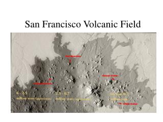
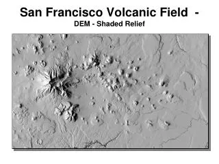
Arizona's Hotspot • Continental Hotspot Volcanism: Hotspots are thought to be caused by a narrow stream of hot mantle convecting up from the Earth's core-mantle boundary called a mantle plume • The San Francisco Volcanic Field is comprised of more than 600 volcanoes-most of them relatively small cinder cones-scattered over an area of about 1,800 square miles.
Arizona's Hotspot • Most hotspot volcanoes are basaltic because they erupt through oceanic lithosphere (e.g., Hawaii, Tahiti). As a result, they are less explosive than subduction zone volcanoes, in which water is trapped under the overriding plate. • Where hotspots occur under continental crust, basaltic magma is trapped in the less dense continental crust, which is heated and melts to form rhyolites. These rhyolites can be quite hot and form violent eruptions, despite their low water content.
Geologic Background: • The San Francisco volcanic field ranges in composition from basalt to rhyolite and began activity about 6,000,000. • Sunset Crater, northeast of San Francisco Mountain, is the youngest feature in the volcanic field.
Volcanoes and Types of Magma • Most of the more than 600 volcanoes in the San Francisco Volcanic Field are basalt cinder cones. • Basalt has the lowest viscosity of all common magmas. • Cinder cones are are built when gas-charged frothy blobs of basalt magma are erupted as an upward spray, or lava fountain.
Volcanoes and Types of Magma Once sufficient gas pressure has been released from the supply of magma, lava oozes quietly out to form a lava flow. This lava typically squeezes out from the base of the cone and tends to flow away for a substantial distance because of its low viscosity.
Stratovolcanoes • Stratovolcanoes have moderately steep slopes and form by the accumulation of layer upon layer of intermediate-viscosity (andesite) lava flows, cinders, and ash, interspersed with deposits from volcanic mudflows (lahars) at lower elevations.
Stratovolcanoes • San Francisco Mountain is the only stratovolcano in the San Francisco Volcanic Field and was built by eruptions between about 1 and 0.4 million years ago.
Lava Domes • The San Francisco Volcanic Field also includes several lava domes. Lava domes are formed by dacite and rhyolite magmas, which have high silica contents. Dacite and rhyolite are so viscous that they tend to pile up and form very steep-sided bulbous masses (domes) at the site of eruption.
Lava Domes • Elden Mountain, at the eastern outskirts of Flagstaff, is an excellent example of an exogenous dacite dome and consists of several overlapping lobes of lava.
Dacite lava consists of about 63 to 68 percent silica (SiO2). It is one of the most common rock types associated with enormous Plinian-style eruptions. When relatively gas-poor dacite erupts onto a volcano's surface, it typically forms thick rounded lava flow in the shape of a dome.
Humphreys Peak is the highest mountain in Arizona (12,633 feet): Humphreys Peak was named after General A. A. Humphreys who was a US chief of Engineers.
Sugarloaf Mountain, the small dome-shaped hill in the foreground, is a rhyolite dome. Quarries at the base of the dome (bottom-right) mine pumice. The quarries are in an older dome that predates Sugarloaf Mountain by about 500,000 years. • Many volcanologists believe that the scooped-out shape of the San Francisco Peaks may be the result of a catastrophic sideways blast like that of Mount St. Helens.
Major Volcanic Events in Northern Arizona • 6 million yrs ago: the first volcanoes begin to erupt in the San Francisco Volcanic Field. • 3 million yrs ago: Kendrick Peak forms north of Flagstaff. • 430,000 yrs ago: the Peaks reach their highest elevation. • 400,000-200,000 yrs ago: San Francisco Mountain erupts- decapitating the peak and forming the Basin. • 200,000 yrs ago: O’Leary Peak north of Sunset Crater erupts.
Major Volcanic Events in Northern Arizona • 70,000 yrs ago: SP Crater north of Flagstaff erupts. • 933 yrs ago: Sunset Crater erupts (last active eruption in the volcanic field). Aa flow near to Sunset Crater
Red Cinder Cone near Sunset Crater Collapsed Lava Tube
SP Crater, in the San Francisco Volcanic Field, is an excellent example of a cinder cone and associated lava flow. This flow extends 4 miles from the cone and is only about 100 feet thick.
Volcanoes get younger to the east. This is consistent with the westward motion of the North American Plate over a fixed hotspot. Map of Volcanic Rock Distribution near the Colorado Plateau
The geochronology of the San Francisco volcanic field has been studied fairly extensively beginning with Robinson ( 1913) who divided the rocks into three periods of eruption: • basaltic volcanics, probably of the late Pliocene, • rhyolitic to andesitic volcanics, probably of the early Pleistocene, and • basaltic volcanism, probably of the latter part of the Quaternary.
The Hopi Buttes volcanic field is in the southern part of Black Mesa Basin. Igneous rocks in the Hopi Buttes were intruded as dikes and sills, and erupted pyroclastics, lava flows and lava domes. About 200 volcanoes erupted during the Pliocene (Sutton, 1974). Depending on the materials that filled volcano vents after eruption, three topographic forms evolved that characterize the Hopi Buttes field:
The Hopi Buttes volcanic field is in the southern part of Black Mesa Basin.
The Hopi Buttes volcanic field is in the southern part of Black Mesa Basin. • prominent necks, or plugs, that rise above the landscape as narrow, nearly circular and steep-sided buttes surrounded by talus slopes, • lava-capped mesas that resulted from the erosion of lava domes on flows that overlie maar craters, and • maar craters that have no protective covering of lava, massive breccia or agglomerate.