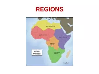
Exploring Texas Regions: Identify the Areas of Mountains, Basins, and More
In this interactive challenge, you'll explore various regions of Texas through pictures and information provided on slides. Your task is to identify the specific region or sub-region that each image or detail refers to, using abbreviations such as Coastal Plains (CP), North Central Plains (NCP), Great Plains (GP), and Mountains and Basins (MB). From features like the Pecos River and rainfall statistics to notable sub-regions like the Edwards Plateau, put your knowledge to the test!

Exploring Texas Regions: Identify the Areas of Mountains, Basins, and More
E N D
Presentation Transcript
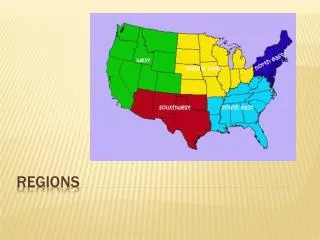
Regions Challenge Number the back of your Mountains and Basins notes from 1 to 23 You will see some pictures or information on the following slides. Your job is to tell me which region or sub-region the picture/information is referring to. You may abbreviate the following way: Coastal Plains = CP North Central Plains = NCP Great Plains = GP Mountains and Basins = MB
Which Region(s)? 1. • Pecos River
Which Region(s)? 4. • 8” of rain a year
Austin Which Region(s)? 5.
Which Region(s)? 6. Maquiladoras
Which Region(s)? 8. • Rolling Plains • Cross Timbers • Grand Prairie
Which Region(s)? 10. and
Which Region(s)? 11. • 55” of rain a year
Which Region(s)? 12.
Which Region(s)? 13.
Which Region(s)? 14.
Which Region(s)? 15.
Which Region(s)? 16.
Which Region(s)? 17.
Which Region(s)? 18.
Which Region(s)? 19. • High Plains • Edwards Plateau (Hill Country) • Llano Basin
Which Region(s)? 20.
Which Region(s)? 21.
Which Region(s)? 22. Which region do we consider Murchison Middle School to be in? 23. Which region do we consider the capitol building (downtown Austin) to be in?
Which Sub-Regions? Bonus #1 Bonus #2 and