Download
1 / 30
300 likes | 481 Views
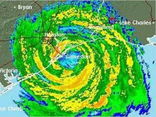
Hurricane Ike Recovery Efforts in Unincorporated Areas of Galveston County Presented to NWF Conference February 28, 2012 Michael Tehrani, P.E., CFM Dewey H. Brunt III, P.E. Hurricane Ike Recovery. Hurricane Ike. Landfall on Galveston Island on September 13, 2008

E N D
Hurricane Ike Recovery Efforts in Unincorporated Areas of Galveston County Presented to NWF Conference February 28, 2012 Michael Tehrani, P.E., CFM Dewey H. Brunt III, P.E.
Hurricane Ike Recovery Hurricane Ike • Landfall on Galveston Island on September 13, 2008 • Category 2 Storm - sustained winds of 110 mph, storm surge 5 to 17 feet. • Estimated $27 billion in damages, 3rd costliest in U.S. history. • Thousands of homes damaged or destroyed. • Damage Inspection Teams from 3 consultants were mobilized on September 21, 2008.
Hurricane Ike Recovery Galveston County Storm Surge 14.8 ft 12.6 ft 12.0 ft 16.0 ft
Hurricane Ike Recovery Galveston County Inundation Depths
Hurricane Ike Recovery NFIP Requirements • Substantially Damaged Structures are those that the cost of restoring the structure to its pre-damage condition equals or exceeds 50 percent of the pre-damage market value. • When repaired, Substantially Damaged Structures within the floodplain are required to have the lowest floor elevated to or above the base flood elevation.
Hurricane Ike Recovery Problem • Thousands of structures damaged or totally destroyed • Displaced residents needed to get back to their homes to begin repairs • Determine degree of damage to structures so that building permits could be issued
Hurricane Ike Recovery Damage Assessments • Galveston County Unincorporated Areas • Mainland • Bolivar Peninsula • Phased Process • Preliminary Damage Assessments • Detailed Inspections / Residential Substantial Damage Assessments (RSDE)
Hurricane Ike Recovery Damage Assessment Tools • GIS • Galveston County Appraisal District (GCAD) • FIRM Maps • FEMA’s RSDE Software, Forms & Guidelines • Aerial Images • Pre Ike • Post Ike • Excel Summary Sheet
Hurricane Ike Recovery Challenges for Processing the Data • Thousands of Structures required Inspection • Coordination Between Consultants • Coordination with Galveston County • Coordination Between Office and Field Inspection Crews • Accuracy • Consistency • Organization and Accountability
Hurricane Ike Recovery Why Use GIS? • Organizational Integration • GCAD Data • RSDE Software • Excel Spreadsheet (Summary Report) • Aerial Photos • Inspection Photos • Make Better Decisions • Query Information • Analyze Information • Make Maps • Excellent Quality • High Flexibility • Very Fast
Organizational Integration Hurricane Ike Recovery
Hurricane Ike Recovery GCAD Data Example
GCAD Data - San Leon Hurricane Ike Recovery
Huitt-Zollars Project Limits Hurricane Ike Recovery BROADWAYST
Floodplain Boundary Hurricane Ike Recovery
Structures to be Inspected Hurricane Ike Recovery
Hurricane Ike Recovery GIS Map-Making Example – San Leon • Overlay with parcel and address data • Overlay with aerial photo • Identify parcels to be inspected • Verify number of structures on each parcel • Expedited damage inspections
Hurricane Ike Recovery Preliminary Damage Assessment Map
Detailed Inspection Map Hurricane Ike Recovery
Hurricane Ike Recovery Substantially Damaged Structures
Hurricane Ike Recovery Unincorporated Mainland Area Preliminary Damage Assessment Structures Minimal or Minor Damage 1,236 Potential Substantial Damage 1,774 Total 3,010 Detailed Inspection Of the 1,774 Potential Substantial Damage Structures, 564 were classified as Substantially Damaged.
Hurricane Ike Recovery GIS Map-Making Example – Bolivar • Use of Pre- and Post-Ike Pictometry • Overlay with parcel and address data • Identify totally destroyed structures • Identify parcels to be Inspected • Expedited damage inspections
Hurricane Ike Recovery USGS Oblique Aerial Photo of Bolivar Peninsula
Hurricane Ike Recovery USGS Oblique Aerial Photo of Bolivar Peninsula
Pre–Ike Parcel Map Hurricane Ike Recovery
Post–Ike Parcel Map Hurricane Ike Recovery
Hurricane Ike Recovery Bolivar Peninsula Preliminary Damage Assessment • Structures • Minimal or Minor Damage 1,064 • Potential Substantial Damage 663 • Destroyed or Washed Away 3,451 • Total 5,178 Detailed Inspection • Of the 663 Potential Substantial Damage Structures, • 229 were classified as Substantially Damaged
Hurricane Ike Recovery New Technology FEMA SDE Program Geocoded Photos • Reduce Inspection Time • Reduce processing Time • Increased Organization & Accuracy • Improve Decision Process • Limited to Outside of Structures
Hurricane Ike Recovery Geocoded Photos 7th
Hurricane Ike Recovery Questions