Download
1 / 46
460 likes | 593 Views
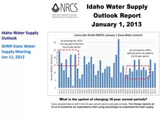
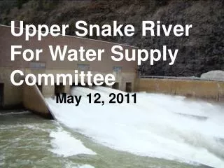
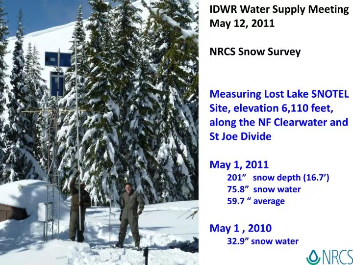
IDWR Water Supply Meeting May 12, 2011 NRCS Snow Survey Measuring Lost Lake SNOTEL Site, elevation 6,110 feet, along the NF Clearwater and St Joe Divide May 1, 2011 201” snow depth (16.7’) 75.8” snow water 59.7 “ average May 1 , 2010 32.9” snow water.

E N D
IDWR Water Supply Meeting • May 12, 2011 • NRCS Snow Survey • Measuring Lost Lake SNOTEL Site, elevation 6,110 feet, along the NF Clearwater and St Joe Divide • May 1, 2011 • 201” snow depth (16.7’) • 75.8” snow water • 59.7 “ average • May 1 , 2010 • 32.9” snow water
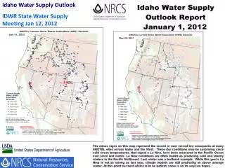
May 10, 2011 SWE range is 125-260% of average May 10, 1997 SWE range was 60-195% of average
New analysis using soil moisture to forecast streamflow from Western Snow Conference
From: Magic Reservoir Operation Guide 1996 May 1 May-Jul Forecast 50% Chance 134% 30% Chance 148% Status Level 4 Table shows storage can be 180,000 AF on May 10 May 1 was 176,800 AF
Based on average snow melt peak flow ~30 days out, in mid-June
Fly Over -- Two Ocean Plateau SNOTEL April 26, 2011 Thanks to USBR for providing helicopter funding to fix site. We are ‘on call’ from National Park Service. Scheduled to fly Friday May 13 pending and weather
Based on maximum forecast only From Salmon Falls Creek Reservoir Operating Guide 1997 May 1, 2011 Conditions Reservoir Storage 92.1 KAF , ~50 feet May-July Streamflow Forecast Max = 160 KAF (281%) 30% = 136 KAF (136%) 50% = 121 KAF (121%) 70% = 107 KAF (107%) Min = 88 KAF (88%) May-July Avg = 57 KAF Salmon Falls Creek Streamflow May 1 Inflow = 564 cfs May 11 inflow = 1130 cfs ↑ Full Reservoir
Mid-April near Tammany, Idaho southeast of Lewiston where they normally receive 14 inches of precipitation a year on the prairie
Basin is saturated, already set several new daily high peak flows, May 1 snowpack in 1976 was a little less than this year
2008 & 1997 were recent high snow years. Coeur d’Alene Lake went 6 ¾ feet above summer level in 2008 and 8.1 feet in 1997. We (Avista) are projecting that CDA lake will reach between 6-8 feet above summer level (2134 - 2136) sometime in May or early June. Flood stage is 2133. Resulting peak flows in the Spokane river will be 36,000-43,000 cfs. Of course it all depends upon the weather and how fast the snow melts… Other concerns of near record high mid-elevation snow in CDA basin
March Valley Temperature & Precipitation for Analog Years 1917, 71, 74, 89, 08
May Valley Temperature & Precipitation for Analog Years 1917, 71, 74, 89, 08
April to June Valley Temperature & Precipitation for Analog Years 1917, 71, 74, 89, 08
April to June Valley Temperature & Precipitation for Analog Years 1917, 71, 74, 08 (NOT 1989)