Download
1 / 85
850 likes | 1.01k Views
The Public Land Survey System GIS Framework:. How it applies to Surveyors, Assessors, Recorders and the general public. Lorraine Wright, IDEM and IGIC Geodetic Workgroup Co-Chair Gary Kent, The Schneider Corporation IGIC GIS Conference - March 13, 2007.

E N D
The Public Land Survey System GIS Framework: How it applies to Surveyors, Assessors, Recorders and the general public Lorraine Wright, IDEM and IGIC Geodetic Workgroup Co-Chair Gary Kent, The Schneider Corporation IGIC GIS Conference - March 13, 2007
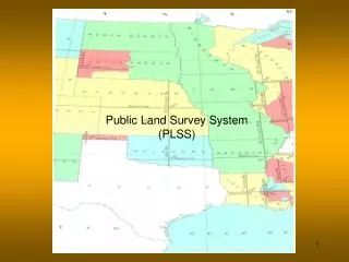
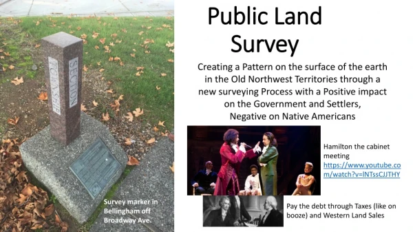
The Public Land Survey System (PLSS) Legal or GIS Framework Legal PLSS • Based on law and the original PLSS • A PLSS corner location is represented by a monument or marker in the ground • Laws changed over time and so did the boundaries • Boundaries, deeds, and parcel descriptions are based on PLSS corner locations • Only Licensed Surveyors can define Legal coordinates for the PLSS corners
PLSS FrameworkLegal or GIS • GIS PLSS Framework • Few Legal coordinates exist • What is needed to get Legal coordinates? • Work with the surveying community • Work with the County Surveyor to develop a plan to get Legal coordinates when the corners are perpetuated
PLSS FrameworkLegal or GIS • GIS PLSS Framework • Create a way to identify all PLSS corners state-wide graphically • Tie Card Pilot Project • Grid points represent approximate corner locations • Points cannot be used for legal purposes • County Surveyor public records for three counties were scanned and linked to Grid points
PLSS FrameworkLegal or GIS GIS PLSS Framework • The implementation of County legal requirements can affect the creation and accuracy of a GIS PLSS Framework by: • Surveyors • Assessors • Recorders • Resulting implementation of requirements can then affect the Property Owner
Gary R. Kent Director, Integrated ServicesThe Schneider Corporation • What you need to know about surveying and the Legal PLSS
The Public Land Survey System GIS Framework: • Overview of some of the Assessor and Recorder requirements • Overview and demonstration of the Tie Card Project
PLSS FrameworkLegal or GIS GIS PLSS Framework • The implementation of County legal requirements can affect the creation and accuracy of a GIS PLSS Framework by: • Surveyors • Assessors • Recorders • Resulting implementation of requirements can then affect the Property Owner
County Assessor • Countywide equalization • Select and maintain a county wide computer system • Certify gross assessments • Discover omitted property • Requirements by Law, IC 36-2-15
Assessor • Calculates the assessed value of all real property in each taxing district. • Calculates the total assessed value of each taxing district. • Listed on Hendricks County Assessor website
Recorder • Records: • Deeds for real estate • Mortgages on real estate • Affidavit; recording in miscellaneous records; record as prima facie evidence • An affidavit that: (1) concerns the birth, marriage, death, name, residence, identity, or relationship of any of the parties named in an instrument affecting real property; • Required by Law, IC 36-2-11
Questions? • Miscellaneous Records - Are these files searched when properties are sold or when title searches are done? • Are all Environmental Notices/Environmental Restrictive Covents and deed restrictions recorded in the County Recorder’s office? • How does a property owner know if there are Environmental Notices/Environmental Restrictive Covenants, deed restrictions, or liens associated with a property of interest? • How does the prospective property owner know all the information they need before considering a property purchase?
What you need to know • Cadastral (parcel) GIS layers should be tied to surveyed PLSS section corners (surveyed by licensed surveyors) • When the parcel boundaries are tied to PLSS section corners the parcel boundaries and lot lines may not fit together nicely (that is reality) • Parcel measurements from a Cadastral GIS map (parcel layer) should not be used for a legal boundary or property line interpretations
What you need to Know(cont.) • Need mechanism for cross referencing all data sources by geography (GIS) • Need Legal PLSS Corner coordinates so we are all working from the same framework • 2005 Aerial Orthophotography - based on limited number of Legal PLSS corners • Deeds define geography – measured from Legal PLSS corners • Parcels are defined by deeds and should relate to Legal PLSS corners • Addresses relate to parcels
What you need to know(cont) • The Surveyor, Assessor and the Recorder are dealing with requirements that are based on the fundamental Public Land Survey System (PLSS) • Counties need to develop a plan so that when section corners are perpetuated the Surveyor will be able to collect a Legal coordinate at the same time. This will require an additional cost, but if the coordinate is collected at the same time the corner is perpetuated, it will actually save money. • County Office’s need to work together to develop a plan so that their GIS system can be based on the Legal coordinates
What you need to know(cont) • Tax and property evaluations relate to parcels and structures on the parcels • Property restrictions and Institutional Controls • May apply to the entire parcel or a subset of a parcel and that is defined by geography (measured from Legal PLSS corner) • Need the Legal PLSS framework – so all data can be related across: • Local • County • State • Federal • Private groups
IGIC Geodetic Workgroup Goals • Develop a Geodetic GIS Framework Layer based on Surveying information • Wanted coordinates state-wide • Found most Geodetic coordinates are housed at the National Geodetic Survey (NGS) • Develop a GIS PLSS Framework based on surveying information (Legal coordinates) • Legal coordinates were not available so we set out to develop a product that would be beneficial to citizens, and both the Surveying and GIS community
IGIC – Geodetic Workgroupworked with Surveying community Participants • Indiana Geographic Information Council (IGIC members – federal, state, county, local, private) • Indiana Society of Professional Land Surveyors (ISPLS) • Office of the Indiana State Geodetic Advisor • Indiana County Surveyors Association • Private Companies • Indiana Geological Survey
Planning for Legal PLSS Coordinates • Draft document: Discussion Paper for Developing a Strategy for Collecting Surveyed (Legal) Coordinates for the PLSS corners, state-wide - February 8, 2006 • Posted on IGIC website/Committees/ • Geodetic Workgroup/ Meeting Minutes February 8, 2006
Specifications for Legal PLSS Coordinates • There are no State mandated accuracy requirements for collecting (legal) coordinates for Perpetuated Corners • A standardized minimum accuracy requirement would be needed for collecting coordinates for Perpetuated Corners, if a state-wide initiative moves forward. This would assure a type of quality control for the Legal coordinates
Tie Card Pilot ProjectGIS Framework Layer • Process for combing County Tie Cards into a statewide system (voluntary participation) • A Tie Card is a scanned image of a County’s Public Land Survey System Corner Description (how to find the marker or monument)
1.Develop a Statewide File Naming Convention • Surveyors might describe a Public Land Survey Section corner as the NE corner, NW 1/4, SE1/4, Section 03,T23N, R06W • Different Counties have different corner naming conventions for the corners • Needed a way to link different data together
1.Develop a Statewide File Naming Convention (cont) Statewide naming convention • IN02_T23NR06E03_08 • Computer File Name will include – (example) • State Name and Principal Meridian – IN02 • Township number - T23 • Township direction – N • Range number – R06 • Range direction – E • Section – 03 • Grid Number – 08 (Grid numbering system begins with 00 in upper left hand of section and ends in 80, bottom right corner)
2. Develop a GRID Point GIS Layer (cont) • The Grid Point GIS layer (developed for the project by Brian Wood) was computer generated using the GIS section boundary layer (developed by IGS) • Each point is named with the state-wide naming convention
Bartholomew Co. IN02_T9NR5E (sections 1-36) Computer generated Grid Points in Section 36
Grid Points for a section Bartholomew Co. IN02_T9NR5E36 Sections are 1 mile by 1 mile
Grid Points showing approximate locations of Original 8 PLSS Corners and Center
3.Develop the Renaming Software • Tie Card Renaming Software (created by Brian Wood, Paul I. Cripe) • Created to aid in viewing the scanned Tie Cards, while renaming the Card with the state-wide naming convention • Creates a database in the background with the entry of key elements from the scanned Tie Card
Tie Card Renaming Software (created by Brian Wood, Paul I. Cripe) Lorraine Wright, 3/13/07
4.Create a Geographic Information System (GIS) Tie Card Layer • Link the Grid Point layer to the database (created after using the renaming software)
5.Bartholomew County - Click on Grid Point and the Tie Card pops up • Section 20. T9NR5E, Second Principal Meridian Grid Points, Bartholomew Co.
7.Create a website to provide easy access to Tie Card Project:IGS is hosting the Tie Card Layer
8. Disclaimer added to inform the public of use restrictions Metadata file available for the Tie Card Layer also includes use restrictions
9. Tools added to make it easy to search (IGS) • Zoom to County, location or area • Enter the Township, Range and Section • Use the identify tool to click on the Corner of interest • The Tie Card pops up • Print the document
Tie Card Project on the Web • The IGS website contains many state-wide GIS layers • Tie Card Project is create by the user by turning on a minimum 4 GIS layers • Landsurvey - Sections • Landsurvey - Township • Surveyor - Tie Cards • Aerial Photos 2005
Scroll to the bottom and click on the map