Dynamic Google Earth Integration with Database Link Workflow
Learn how to create dynamic links between databases, Google Earth, and web services. Utilize Intergraph WebMap feature services or WebMap services via Google network links for seamless navigation and data rendering. Contact Farallon Geographics for programming details.

Dynamic Google Earth Integration with Database Link Workflow
E N D
Presentation Transcript
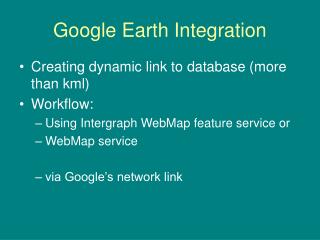
Google Earth Integration • Creating dynamic link to database (more than kml) • Workflow: • Using Intergraph WebMap feature service or • WebMap service • via Google’s network link
Workflow: • Users clicks on ……..netLink url • Link calls .Net web page • (See xml document) • Google E calls url found in <href> tags on netlink document • Navigation is refreshed by Google E • url calls webpageWebMap service or WebMap feature service • Web Services return xml documents from geodatabase • XSLT used to convert wms/wfs to kml • kml renders results
Xml returned from .NET webnetworklink.kml <name>City of San Mateo Rasters</name> <LookAt> <longitude>-122.338515</longitude> <latitude>37.557599</latitude> <range>300</range> <tilt>0</tilt> <heading>0</heading> </LookAt> <NetworkLink> <name>Raster Image</name> <Url> <href>http://CityOfSanMateo_Domain/virtualdirectory/googleEarth.aspx?theme=(parcels or parcelsRaster)</href> <viewRefreshMode>onStop</viewRefreshMode> <viewRefreshTime>.5</viewRefreshTime> <viewFormat>BBOX=[bboxWest],[bboxSouth],[bboxEast],[bboxNorth]&LOOKAT=[lookatLon],[lookatLat],[lookatRange],[lookatTilt],[lookatHeading]&HFOV=[horizFov]&VFOV=[vertFov]</viewFormat> </Url> <viewRefreshMode>onStop</viewRefreshMode> </NetworkLink> </Folder> </kml>
Programming functions: Server Intergraph generated Web Page Request.asp Farallon Geographics created Web Page googleEarth.aspx Client Network Link Google Earth GeoMedia WebMap Service XSLT XSLT Used to convert wms/wfs to kml Contact Farallon Geographic's for programming details