Download
1 / 35
350 likes | 499 Views
SLR Science Applications and ILRS Products. Erricos C. Pavlis Goddard Earth Science and Technology Center (GEST), University of Maryland, Baltimore County & NASA Goddard 698. Meeting with Colombian Delegation GSFC, Greenbelt , September 26, 2011.

E N D
SLR Science Applications andILRS Products Erricos C. Pavlis Goddard Earth Science and Technology Center (GEST), University of Maryland, Baltimore County & NASA Goddard 698 Meeting with Colombian Delegation GSFC, Greenbelt, September 26, 2011
Satellite Laser Ranging - the Technique Precise range measurement between an SLR station and a satellite using ultra-short laser pulses. • Simple range measurement • Space segment is passive • Simple refraction model • Night / Day Operation • Near real-time global data availability • Satellite altitudes from <300 km to geosynchronous satellites, and the Moon (Mars also with transponders) • Unambiguous ~ cm accurate orbits • Long-term stable geophysical time series Meeting with Delegation from Colombia, GSFC, September 26, 2011
SLR Science and Applications • Primary Products (Level 1) • Precision Orbit Determination (POD) • Time History of Station Positions and Motions & EOP • Science Products (Level 2) • Terrestrial Reference Frame (Center of Mass and Scale) • Plate Tectonics and Crustal Deformation • Static and Time-varying Gravity Field (C/Sn,m) • Earth Orientation Parameters (EOP: Polar Motion, length of day) • Orbits and Calibration of Altimetry Missions (Oceans, Ice) • Total Earth Mass Distribution • Space Science - Tether Dynamics, etc. • Relativity Measurements and Lunar Science • More than 60 Space Missions Supported since 1965 • Four Missions “Rescued” in the Past Decade Meeting with Delegation from Colombia, GSFC, September 26, 2011
The ILRS Network NORTH SITES: 16 SOUTH SITES: 7 ILRS Meeting with Delegation from Colombia, GSFC, September 26, 2011
Non-uniform System Performance Across Sites & Time Meeting with Delegation from Colombia, GSFC, September 26, 2011
GGOS2020 Core Network NORTH SITES: 16 SOUTH SITES: 7 Meeting with Delegation from Colombia, GSFC, September 26, 2011
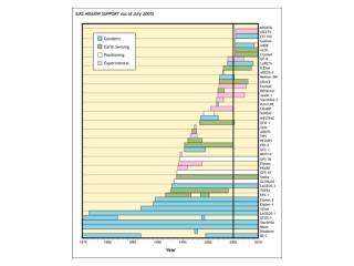
ILRS-Tracked Satellite Missions(POD Support 3Q2011) Meeting with Delegation from Colombia, GSFC, September 26, 2011
SLR Geodetic Satellite Constellation Ajisai LARES Starlette Etalon-I & -II LAGEOS-2 Stella LAGEOS-1 LARES A/m = 0.36 x LAGEOS Meeting with Delegation from Colombia, GSFC, September 26, 2011
Current SLR Error Budget Meeting with Delegation from Colombia, GSFC, September 26, 2011
ILRS Analysis Working Group (AWG) Products and Services • Nine ACs and two CCs: • ASI, BKG, DGFI, ESA, GA, GFZ, GRGS, JCET, and NSGF • AWG Products and Services: • Operational weekly & daily products routinely delivered • ITRF2008-based TRF used internally (SLRF2008) • Daily data QC and station feedback • Orbit products (SP3C files) • Long-wavelength gravity variations (for GGOS) • New & returning station validation • Validation of new data format (CRD) Meeting with Delegation from Colombia, GSFC, September 26, 2011
Geocenter Variation from SLR Meeting with Delegation from Colombia, GSFC, September 26, 2011
Geocenter Motion Earth's center of mass relative to the origin of ITRF2000, projected in the equatorial plane. Large excursions have been correlated with recent El Niño events (1996-97 and 2002-03). Motion of the ITRF origin w.r.t. the geocenter with secular trends removed • Shown here is the change in the origin of the crust-fixed frame w.r.t. the center of mass due to non tidal mass transport in the atmosphere and hydrosphere. Meeting with Delegation from Colombia, GSFC, September 26, 2011
SLR in ITRF2008 ORIGIN TZ SCALE From ZuheirAltamimi, ITRS Meeting with Delegation from Colombia, GSFC, September 26, 2011
Earth’s Oblateness from SLR(seasonal variation removed) Cheng and Tapley (2004) Secular trend significantly affected if time series is not long enough Cox and Chao (2002) Meeting with Delegation from Colombia, GSFC, September 26, 2011
Lunar Laser Ranging (LLR) • 42 years of observations • Post-newtonian model at cm level • high long-term stability (orbit, reference frames, Earth orientation) • relativity tests Meeting with Delegation from Colombia, GSFC, September 26, 2011
Number of LLR NPs • 1970 - 2011: ca.17,000 normal points Meeting with Delegation from Colombia, GSFC, September 26, 2011
LRO Laser Ranging • Transmit 532nm laser pulses at 28 Hz to LRO • Time stamp departure and arrival times Greenbelt, MD LRO Receiver telescope on High Gain Antenna System (HGAS) routes LR signal to LOLA LOLA channel 1 detects LR signal LR Receiver Telescope Fiber Optic Bundle Meeting with Delegation from Colombia, GSFC, September 26, 2011
Summary • SLR is an integral part of the Space Geodetic Networks (Past, Present and Future) • SLR Products support a large gamut of scientific investigations in many disciplines • The contribution of SLR to the ITRF is crucial and unique (Origin) • The new global network will build on the past achievements and extend our capabilities to well beyond what we do today • We are always looking for new partners! Meeting with Delegation from Colombia, GSFC, September 26, 2011
Back-up slides Meeting with Delegation from Colombia, GSFC, September 26, 2011
ILRS-Station Performance LAGEOS RMS over the past year 2 cm 1 cm Meeting with Delegation from Colombia, GSFC, September 26, 2011
ITRF2008 Scale: mean of VLBI and SLR ± 1ppb (6.4 mm at the equator) Meeting with Delegation from Colombia, GSFC, September 26, 2011
Non-uniform Network Evolution Meeting with Delegation from Colombia, GSFC, September 26, 2011
The Next Generation SLR Systems The next generation systems will operate with: higher repetition rate (100 Hz to 2 kHz) lasers to improve data yield, improve normal point precision, and pass interleaving; photon-counting detectors to reduce the emitted laser energies by orders of magnitude and reduce optical hazards on the ground and at aircraft (some are totally eye-safe); multi-stop event timers with few ps resolutions to improve low energy performance in a high solar-noise environment; considerably more automation to permit remote and even autonomous operation; Many systems will operate at single photon levels with Single Photon Avalanche Diode (SPAD) detectors or MicroChannel Plate PhotoMultiplier Tubes (MCP/PMTs). Some systems are experimenting with two-wavelength operations to test atmospheric refraction models and/or to provide unambiguous calibration of the atmospheric delay. • UAW, ETH, Zürich, Switzerland, 16-17 September, 2011
Target signature (CoM) Meeting with Delegation from Colombia, GSFC, September 26, 2011
Target Signature (CoM) Meeting with Delegation from Colombia, GSFC, September 26, 2011
Target signature (CoM) Meeting with Delegation from Colombia, GSFC, September 26, 2011
BLITS – Ball Lens In The SpaceSatellite Meeting with Delegation from Colombia, GSFC, September 26, 2011
LARES - LAser Relativity& Earth ScienceSatellite • LARES Parameters: • Material Tungsten alloy (95%) • Diameter ~36 cm • Mass ~420 kg • Altitude 1500 km • Inclination ~70° • Eccentricity Circular orbit • CCRs(92) LAGEOS type • A/m ratio 0.36 x LAGEOS Launch is with ESA’s new launcher VEGA, on its inaugural test launch, in late 2011/ early 2012 UAW, ETH, Zürich, Switzerland, 16-17 September, 2011
The LAGEOS III Experiment LARES The original SLR experiment (LAGEOS III) expected exactly counter-rotating satellites in supplementary inclinations, to cancel classical Newtonian rates and isolate thegravitomagneticprecession. LARES will be based on the same principle. Meeting with Delegation from Colombia, GSFC, September 26, 2011
Space Geodetic Network Meeting with Delegation from Colombia, GSFC, September 26, 2011
Atmospheric Loading (ECMWF) Meeting with Delegation from Colombia, GSFC, September 26, 2011
Gradient-corrected SLR Residuals Statistics Meeting with Delegation from Colombia, GSFC, September 26, 2011
LAGEOS 1 Statistics for 2008 Actual ILRS Data !!! Meeting with Delegation from Colombia, GSFC, September 26, 2011
LAGEOS 2 Statistics for 2008 Actual ILRS Data !!! Meeting with Delegation from Colombia, GSFC, September 26, 2011
IERS Conventions 2010 The ILRS AWG complies with the IERS Conventions as they evolve, although our products change at specific instants, usually with a re-analysis of all data, in order to keep our online available products consistent. The 2010 Conventions will become our official standard once we release our next re-analysis (sometime in mid-2012). http://www.iers.org/nn_11254/IERS/EN/Publications/TechnicalNotes/tn36.html Meeting with Delegation from Colombia, GSFC, September 26, 2011