Download
1 / 7
70 likes | 139 Views
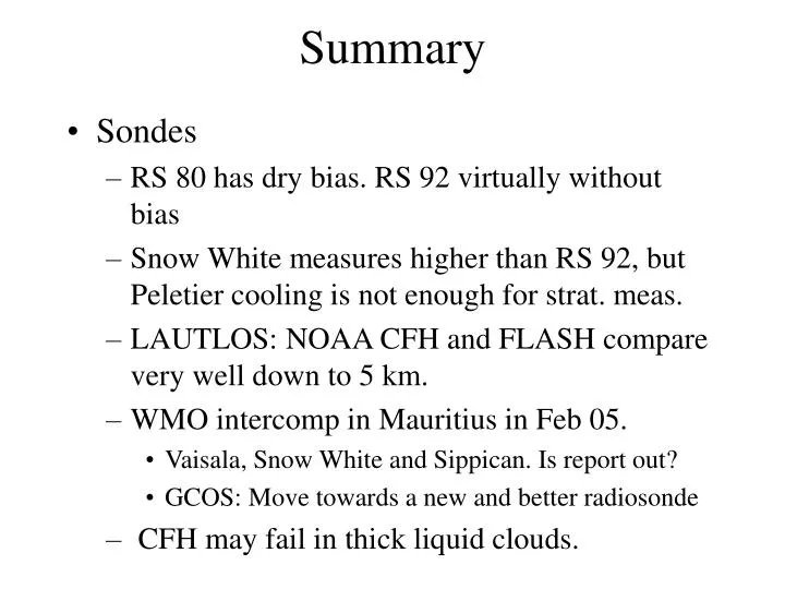
Summary. Sondes RS 80 has dry bias. RS 92 virtually without bias Snow White measures higher than RS 92, but Peletier cooling is not enough for strat. meas. LAUTLOS: NOAA CFH and FLASH compare very well down to 5 km. WMO intercomp in Mauritius in Feb 05.

E N D
Summary • Sondes • RS 80 has dry bias. RS 92 virtually without bias • Snow White measures higher than RS 92, but Peletier cooling is not enough for strat. meas. • LAUTLOS: NOAA CFH and FLASH compare very well down to 5 km. • WMO intercomp in Mauritius in Feb 05. • Vaisala, Snow White and Sippican. Is report out? • GCOS: Move towards a new and better radiosonde • CFH may fail in thick liquid clouds.
Summary • Sondes (Flash, CFH) are probably the best solution for the UTLS region due to the good vertical resolution. • Flash can be reused. • We should have stations with a suite of water vapour instruments. • Bern/Payerne is one possibility. • We also need stations in the tropics
Summary • FT-IR • Hitran 2000 gives much better wv profiles than Hitran 96. • Approx. 3 independent layers. • Very accurate H2O columns • Improved retrieval of UT H2O by combining strong lines and moderately strong lines. • FT-IR well suited for middle troposphere.More difficult in the UT. • Reanalyse old data from e.g. Kitt Peak.
Lidars • Two different techniques: • Raman lidar. Altitude range: surface – 15 km (hygropause) at nighttime. Up to 8 km at daytime. • DIAL (needs to break world records in laser technology). Altitude range: surface-13 km (hygropause) above ground any time. Valid for high altitude site. From a dry site potential to go to 25-30 km • Raman lidar needs calibration. One point along the profile suffices. • DIAL is absolutely calibrated
Microwave • Altitude range: 20-80 km • How well do we know the spectroscopic parameters? • How much does the temperature profile influence the water vapour profile? • Europeans and Americans are using different forward models. • QPACK retrieval code used by some, but not all. • Should the MW working group have a travelling standard like for the FT-IR and lidar WGs. • Possible for some MW instr. to participate at the Table Mountain intercomp. in Oct. 2006?
Combining MW and other techniques • Cross validation of satellites by a GB station • Cross validation of GB stations by a satellite • ”Assimilating” various other measurements in the MW retrieval can give a continuous ”smooth” H2O profile from the ground to the mesopause. More work is needed to develop the technique.
Next steps • Workshop report. • Rapporteurs send their ”clean” notes to Geir. ”Clean” = Good English with complete sentences. No telegram style. Deadline 15.7.2006. • Geir makes draft report that is circulated to the participants. 21.7.2006. • Feedback on draft report by 8.9.2006. • Final report by mid Sept. based on feedback. • Presentation of report at SC meeting at OHP late Sept. • Make an inventory of existing H2O measurements within NDACC. Send info that you might have on existing H2O measurements. • Identify stations that would be suitable/desirable for Flash or CFH measurements. Coordinate with satellite overpasses. • Follow-up meeting? • Water vapour Session at EGU 2008?