Download
1 / 1
10 likes | 103 Views
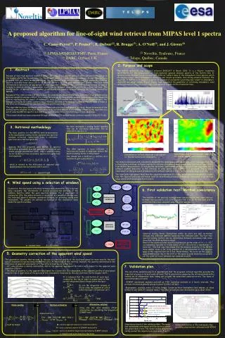
This proposed algorithm aims to retrieve atmospheric wind speed information from MIPAS spectral data by analyzing Doppler shifts due to wind along the line of sight. The algorithm utilizes high spectral resolution MIPAS spectra to derive a vertical line-of-sight wind profile, providing insights into atmospheric chemistry and global change. It focuses on stability of wavenumber scale within a scan sequence for wind retrieval. The algorithm has been developed, coded, and tested on simulated spectra and is currently undergoing testing on selected MIPAS data correlated with meteorological radio-soundings. Supported by an ESA/ESRIN contract study.

E N D
A proposed algorithm for line-of-sight wind retrieval from MIPAS level 1 spectra C. Camy-Peyret(1), P. Prunet(2), E. Dufour(2), R. Brugge(3), A. O’Neill(3), and J. Giroux(4) (1) LPMAA/CNRS&UPMC, Paris, France (2)Noveltis, Toulouse, France (3) DARC, Oxford, UK(4) Telops, Québec, Canada 2. Purpose and scope 1. Abstract The MIPAS instrument was launched on-board ENVISAT in March 2002. It is a Fourier transform spectrometer for the measurement of high-resolution gaseous emission spectra of the Earth’s limb. It operates in the thermal to mid infrared (685-2410 cm-1) where many of the atmospheric trace species, which are playing a major role in atmospheric chemistry and climate processes, have strong emission features. The objective of MIPAS is to measure a series of geophysical parameters providing new insight in atmospheric chemistry and global change. Recent studies have suggested the possibility of retrieving atmospheric wind speed information along the line of sight from spectral Doppler shifts of emission lines. Because of their high spectral resolution (0.035 cm-1 unapodised), MIPAS spectra contain potential information on the Doppler shifts due to wind along the line-of-sight (LOS) in a given limb scan sequence. An algorithm has been proposed that just relies on the stability of the wavenumber scale within a given limb scan sequence (usually 17 spectra recorded from about 65 to 10 km) to derive a vertical LOS relative wind profile. This LOS wind information is derived by an appropriate original algorithm called ANA (for analytical method because an explicit formula is used) producing a wavenumber scaling factor between consecutive spectra in a given limb scan. This scaling factor is derived from a number of optimised wind spectral windows spanning the 5 bands covered by MIPAS. Because of the relative nature of the process, the absolute interband/interwindow calibration is not needed and an optimum weighted average value of the scaling factors can be derived with weights (and an associated occupation matrix) representing the impact of radiometric noise in each window and for each pair of tangent heights. The average scaling factor is then converted to a relative LOS wind difference and, assuming the LOS wind is known at one level, an estimation of the absolute LOS wind profile can be provided. The algorithm has been developed, coded and then tested on simulated spectra (to check the performances of the method and to establish the noise amplification error factors). We are in the process of testing the algorithm on a set of selected MIPAS spectra recorded in correlation with standard meteorological radio-soundings. The present study has been conducted through an ESA/ESRIN contract study (contract number 17896/03/I-LG). 3. Retrieval methodology We have developed a scaling factor operator that can be expressed analytically. The so-called ANA operator is : The basic quantity for the MIPAS wind determination is the wavenumber scaling factor between two spectral windows extracted respectively from a reference spectrum and a shifted spectrum. Knowing that the presently used MIPAS L1 spectral calibration procedure does not guarantee an accurate and stable enough wavenumber scale, only a relative scaling factor is derived from successive spectra in a given limb scan sequence. The ANA operator is more efficient if functions are scaled in amplitude before the spectral scaling factor is determined. One should use a modified y2 written as a function of gain a and offset b : Instantaneous altitude/longitude cross section for the meridional wind component v Instantaneous latitude/longitude cross section for the meridional wind component v The study is concerned with a feasibility study and the development and implementation of new algorithms into a stand-alone prototype software system to retrieve atmospheric wind speed along the line of sight (LOS) from MIPAS measurements. It includes the definition, implementation and validation of new algorithms into a software system dedicated to the retrieval of wind speed from MIPAS L 1 products. The accuracy requirement on the wind speed produced by the software system is 5 m.s-1 in the altitude range 12-40 km. The lower left/right panels show that the expected magnitude of v in the stratosphere/mesosphere is higher than the required precision and hence could be determined, providing interesting information in an altitude range where wind measurements are scarce. which is related to the difference of apparent wind speed between two successive LOS k and k+1 Vk = c k c : speed of light 4. Wind speed using a selection of windows In practice, the wind speed difference between two consecutive LOS is derived using conjointly the information of several pre-selected portions of the radiance spectra called the wind spectral windows. For a given pair of consecutive LOS, the global estimate is calculated as a weighted average over the individual spectral windows considered suitable for providing usable wind information. The weights are defined as function of the radiometric noise inside the spectral window. 6. First validation test: Method consistency The stability of the spectral scale between tow successive limb scans (and not between two successive LOS within a same limb scan as for the wind profile extraction) have been analyzed using the ANA operator. Spectral scaling factor fluctuations within an orbit are well correlated between the different MIPAS bands and the different LOS. The fact that spectral scaling factors can be determined between successive limb scans show that the ANA method is robust. Most of the observed inter-scan fluctuations are on the order of ε 1 10-7 corresponding typically to a wind speed of V = 30 m/s for a wavenumber of 1000 cm-1. This test case then shows that the absolute stability of the MIPAS wave number scale is far from granted for a determination of the absolute wind at the required level of 5 m/s. Nevertheless, the error on the relative wind determination due to the drift of the spectral scale should be acceptable (on the order of 2 m.s-1 between two consecutive LOS). w : window index k : LOS index 5. Geometry correction of the apparent wind speed • The geophysical quantity that we want to retrieve is a vertical profile of the local wind speed (or more exactly, the wind speed component projected along the MIPAS LOS). At this stage of the retrieval, however, the quantity determined is the difference of apparent wind speed Vk. Two effects must be corrected for : • Vk, only provides a relative information, that is the apparent wind speed for LOS k with respect to the apparent wind speed for LOS k+1 • The physical quantity Vk (the apparent wind speed for a given LOS k) is dependent on the complete profile of wind speed along the line of sight since all the parcels of the atmosphere traversed by the LOS contribute to the Doppler shift. 7. Validation plan • The aim of the validation plan is to demonstrate that the proposed retrieval algorithm provides the expected accuracy in term of wind retrieval. This is achieved by comparing the retrieved winds with a limited set of independent data, taking into account the associated expected errors. Two types of operational data are used: • ECMWF operational analyses archived at T159 resolution available at 6 hourly intervals. They provide information globally and up to about 0.1 hPa (~60 km). • Radiosondes, available every 12 hours, largely across northern hemisphere land masses, at about 0000UTC and 1200UTC (nominal times). They provide multiple level information up to about 30 km. It is assumed that the contribution of each layer crossed by the line of sight is proportional to the partial integrated (slant) column within the layer. Qk,lare the integrated columns of dry air along the segment of LOS k within the layer l (in molecule cm-2) = G(v) Alternative solution Using only the wind absolute offset information, by calculating the integrated ECMWF wind Onion peeling Optimal estimation OR OR model profile rms variation model – radiosonde departures radiosonde rms error Square root of model forecast error covariance minimisation of J(v) = (ΔV – G(v))TM-1 (ΔV – G(v) ) + (vECMWF – v)TN-1 (vECMWF – v) J(v) = (ΔV – G(v))TM-1 (ΔV – G(v) ) + (I(vECMWF) – I(v) )T(σvECMWF)-2(I(vECMWF) - I(v)) Consistency check of the validation data. The model and radiosondes wind speed profiles agree to within the prescribed errors. The model-sondes departures rarely exceed the required precision level (5 m.s-1). v1 must be known M : relative apparent wind error covariance matrix N : error covariance matrix of ECMWF wind profile vECMWF : A priori vector of absolute tangent wind provided by ECMWF analysis I : tangent point wind integration functional Global distribution of the radiosonde sites providing observations collocated with MIPAS