Integrating Evaluation Models for Enhanced Air Quality Monitoring and Transport Objectives
This report outlines critical recommendations for advancing air quality monitoring and transport objectives. It advocates for the adoption of model evaluation as a design principle, elevating transport as a primary goal, and establishing key routine measurements. The report emphasizes integrating ground-based and satellite observation systems, ensuring data unification and standards. Highlighting pollutants like CO, NOx, and VOCs, it stresses the need for quality assurance in data collection and the importance of linking various organizational frameworks and methodologies to refine air quality assessments.

Integrating Evaluation Models for Enhanced Air Quality Monitoring and Transport Objectives
E N D
Presentation Transcript
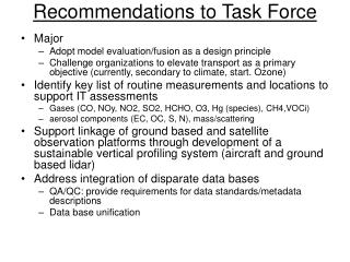
Recommendations to Task Force • Major • Adopt model evaluation/fusion as a design principle • Challenge organizations to elevate transport as a primary objective (currently, secondary to climate, start. Ozone) • Identify key list of routine measurements and locations to support IT assessments • Gases (CO, NOy, NO2, SO2, HCHO, O3, Hg (species), CH4,VOCi) • aerosol components (EC, OC, S, N), mass/scattering • Support linkage of ground based and satellite observation platforms through development of a sustainable vertical profiling system (aircraft and ground based lidar) • Address integration of disparate data bases • QA/QC: provide requirements for data standards/metadata descriptions • Data base unification
United States Ambient Air Monitoring • >$100M annually (routine programs) • Does not include specific inflow/outflow stations • Value/resource allocation? • Anchored in 1970-80’s design model: inertial barrier • Multiple agencies, high concentration emphasis • Intercontinental Transport • Covered through special studies (soft $) • Peripheral benefit of climate/stratospheric ozone • NOAA/NASA Satellite programs • NOAA CMDL (aircraft, ships, buoys, sondes) • National Monitoring strategy (NCore) • Multiple pollutant co-location emphasis • Drive air program policy • Emphasis shift from compliance toward science • Addition of trace (low level ) gas measurements (CO, NOy, SO2, NH3) • Larger integration with satellite and vertical profiling systems
L2 Level 3 NCore Measurements Level 1. 3-10 Master Sites Comprehensive Measurements, Advance Methods Serving Science and Technology Transfer Needs Level 2: ~ 75Multi-pollutant (MP) Sites,“Core Species” Plus Leveraging From PAMS, Speciation Program, Air Toxics L1 Level 3: Minimum Single Pollutant Sites (e.g.> 500 sites each for O3 and PM2.5 and related spatial Mapping Support Minimum “Core” Level 2 Measurements Continuous NO,NOy,SO2,CO, PM2.5, PM10/PMc,O3,Meteorology (T,RH,WS,WD); Integrated PM2.5 FRM, HNO3, NH3,
Observational Systems: Focus? • Design around major assessment tools • Air quality modeling platforms • GEOS-chem, MOZART, CMAQ,….more • Satellite systems • Existing routine surface and aircraft programs • Emphasize • Model evaluation • Linkage of remote and land based systems • Integration of data information systems
Considerations[LRTAP observations guidance] • Emphasis on limited set of key parameters [model evaluation, source apportionment, emissions perspective] • Gases (CO, NOy, NO2?, SO2, HCHO?, O3, Hg?, CH4,VOCi?) • aerosol components (C (EC, OC), S, N), mass/scattering • Meteorological? • Key locations, inflow and outflow perspective • Standardization/QA • Reference material, or method (aerosols) • E.g.,GAW Aerosol Speciation Programme, GASP • Data base, IT standards? • Hemispherical data unification center? • Practical LRTAP task? • Organizational frameworks • Build on IGACO-EMEP efforts • Use guidance to influence participating nations
NCORE Intensive Field studies Goal: Advance air quality model-observation complex to level of meteorological FDDA systems
NAS, CAAAC CASAC, OMB GEOSS NOAA EPA PM research NASA Eco-informatic Test beds CDC PHASE Organizations Private Sector NPS Programs AQ forecasting Risk/exposure assessments States/Tribes/RPO’s Interstate orgs. USDA Accountability/ indicators NAAQS setting DOE NARSTO Coordination Cluster Mess Enviros SIPs, nat. rules designations Academia NADP Satellite data Intensive studies IMPROVE, NCore PM monit, PAMS PM centers Supersites Data sources CASTNET Health/mort. records Other networks: SEARCH, IADN.. Lidar systems Emissions Meteorology CMAQ GEOS-CHEM
What is available? • Organizational frameworks linking observations and modeling…….help or hinder?.....LRTAP direction? • GEOSS • IGOS:IGACO • GAW:GASP • LRTAP • Models • list • Satellite systems • list • Routine measurement programs • Ground based (List) • Vertical profiling (aircraft, sondes, LIDAR) • MOZAIC • NOAA CMDL, NASA