Download
1 / 11
140 likes | 184 Views
Discover the cutting-edge climate research conducted at Thule, Greenland. Explore temperature profiles, aerosol data, and more using advanced instruments. Support upcoming Arctic stratosphere observations.

E N D
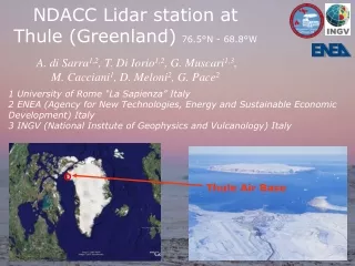
NDACC Lidar station at Thule (Greenland)76.5°N - 68.8°W A. di Sarra1,2, T. Di Iorio1,2, G. Muscari1,3, M. Cacciani1, D. Meloni2, G. Pace2 1 University of Rome “La Sapienza” Italy 2 ENEA (Agency for New Technologies, Energy and Sustainable Economic Development) Italy3 INGV (National Insttute of Geophysics and Vulcanology) Italy Thule Air Base
Aerosol/Temperature lidar (Univ. Roma/ENEA) NDACC Mm-wave spectrometer GBMS (INGV, SUNY) NDACC Spectrometer water vapour VESPA22 GHz (INGV) Solar/IR/PAR radiometers upward-downward (ENEA) HATPRO-RPG Radiometer (ENEA) AllSkyCamera (ENEA) IR Camera (ENEA) Pirometer (ENEA) METCON Actinometer (ENEA) Meteo Station (NCAR, INGV) PM10 sampler (Univ. Firenze) FTIR Spectrometer (NCAR) NDACC Cimel Sun photometer (AERONET; NASA/DMI) Radio/Ozonesonde (DMI) Pyrheliometer and Pyranometer(DMI) UV spectrophotometer (DMI) SAOZ UV-vis Spectrometer (DMI) Dobson Spectrophotometer (DMI) Picarro (NCF)
Aerosol/Temperature lidar (Univ. Roma/ENEA) NDACC Mm-wave spectrometer GBMS (INGV, SUNY) NDACC Spectrometer water vapour VESPA22 GHz (INGV) Solar/IR/PAR radiometers upward-downward (ENEA) HATPRO-RPG Radiometer (ENEA) AllSkyCamera (ENEA) IR Camera (ENEA) Pirometer (ENEA) METCON Actinometer (ENEA) Meteo Station (NCAR, INGV) PM10 sampler (Univ. Firenze) FTIR Spectrometer (NCAR) NDACC Cimel Sun photometer (AERONET; NASA/DMI)→NASA Radio/Ozonesonde (DMI) →ENEA/INGV Pyrheliometer and Pyranometer(DMI) →NCAR UV spectrophotometer (DMI) →NCAR SAOZ UV-vis Spectrometer (DMI) →NCAR Dobson Spectrophotometer (DMI)→NCAR Picarro (NCF)
Elastic Lidar installed since 1990 Ø 800 mm Cassegrain telescope for parallel and cross polarizations (15-70 km, night time) at 532 nm One Ø 50 mm telescope for total and parallel polarizations at 532 nm since 2009 One Ø 50 mm telescope for total backscattering at 1064 and 532 nm since 2014 (0-10 km, day and night time) Nd:YAG laser at 1064 and 532 nm, 20 Hz rep. rate Measurements: Temperature profiles between 25 and 70 km Stratospheric clouds (PSCs) and aerosols Tropospheric clouds and aerosols (0-10 km)
Example of Temperature profiles obtained by lidar on 3 different days (1994-2012- 2016) at Thule. T, T+σ, and T-σ are shown in black lines. The blue dashed line represents the temperature CIRA 1986 model for the specific month. Red dotted profile is closest in time radiosonde data available from Eureka or Alert.
THULE-LIDAR measurements: Mean Temperature between 27 km and 36 km in the period January-February-March of different years 1994-2014
THULE-LIDAR measurements: Mean Temperature between 27 km and 36 km in the period January-February-March of different years 1994-2014 2009 and 2014 Sudden stratospheric warming
Altitude vs time temperature profile carried out with elastic temperature Lidar at Thule during winter 2002, 2009, 2010 and 2014
LIDAR activities during 2016-2018 2016 measurement campaign during summer (aerosol data, no temperature) temperature measurement during november and december NDACC archive: all the data are prepared but not archived yet (PI name problems) 2017 measurement during january and december NDACC archive: all the data were archived SUMMER 2016 The Study of the water Vapour in the polar AtmosPhere (SVAAP) project (PI: Meloni, ENEA) Funded by Italian PNRA is aimed at investigating the variability of atmospheric water vapour, and the long-term variations in stratospheric composition and structure, and in the surface radiation budget. The intensive measurement campaign gave also the possibility to study the cloud physical and optical properties and how they affect the surface radiative budget THULE July 28 2016, 03:15 AM local time
FUTURE ACTIVITIES : Observations of the Arctic Stratosphere In Support of YOPP (OASIS-YOPP) project funded by Italian PNRA (PI: Muscari, INGV) What we plan to do: • measure middle atmospheric water vapour (by means of automatic spectrometers VESPA and HATPRO); • measure middle atmospheric temperature (LIDAR); • radiosounding launch (data otherwise absent in a radius of more than 500 km around Thule). When: • during an intensive spring (Feb-March) field campaign in 2020. What for: • these data sets would be employed to verify the prediction of the timing and the vertical evolution of Stratospheric Final Warmings by Chemistry-Climate Model Project (SFWs occur too late in most CCMs [e.g., Hurwitz et al., 2010]). Additional useful measurements of chemical tracers and Ozone would be provided by NCAR and NSF (USA) . This activity will bring the improvement and upgrade of instruments dedicated to the Polar regions, the increase of observational data in the Arctic, and the verification of prediction capabilities of models.