Rainsford Island
Rainsford Island. 831 . Boston, MA. Tide Graph. X. 18 April 2004. 1400 EST . Station Name . Rainsford Island, Nantucket Shoals. Reference Station Table 1. Subordinate Station Table 2. Tide Table…. Close. Station Number. 831. Reference Station. Boston, Massachusetts. Print. Help.


Rainsford Island
E N D
Presentation Transcript
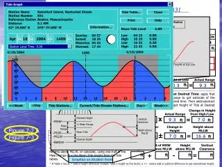
Rainsford Island 831 Boston, MA Tide Graph X 18 April 2004 1400 EST Station Name Rainsford Island, Nantucket Shoals Reference Station Table 1 Subordinate Station Table 2 Tide Table… Close Station Number 831 Reference Station Boston, Massachusetts Print Help Distance 5.1 NM Time Dif to Desired Time Time/Ht of Ref High Information… 42° 19.000’ N 070° 57.000’ W Mean Tide Level 4.8ft Time/Ht of Sub High Low High Low High 04 15 10 29 16 33 22 45 0.0ft 9.6ft 0.3ft 9.9ft Sunrise Sunset Moonrise Moonset 04 57 18 29 04 43 17 44 Apr 18 2004 1400 Height Factor Actual Range Station Local Time -5.00 4/19/2004 4/18/2004 MLLW MLLW 1400 Time/Ht of Sub Low Time/Ht of Ref Low 10ft Time Difference 8ft ^ 6ft 4ft ^ ^ ^ ^ 2ft ^ ^ ^ ^ 0ft -2ft 0 2 4 6 8 10 12 14 16 18 20 22 0 2 4 6 <Day <<Week Tide Stations… Current/Tide Stream Stations… Day> Week>> Charted Height Vertical Clearance MHW ½ Mean Range Mean Range Height above MLLW Mean Tide MLW MLLW Charted Depth Bottom Classroom Exercise 7-1 04 13 L 0.0 -00 02 *0.95 04 11 L 0.0 10 29 H 10.1 00 00 *0.95 10 29 H 9.6 16 31 L 0.3 -00 02 *0.95 16 29 L 0.3 22 45 H 10.4 00 00 *0.95 22 45 H 9.9 9.6 0.3 9.3 14 00 10 29 3 31 Figure 7-2 & Figure 7-3 75 9.3 7.0 9.6 7.0 16.6