Download
1 / 39
390 likes | 562 Views
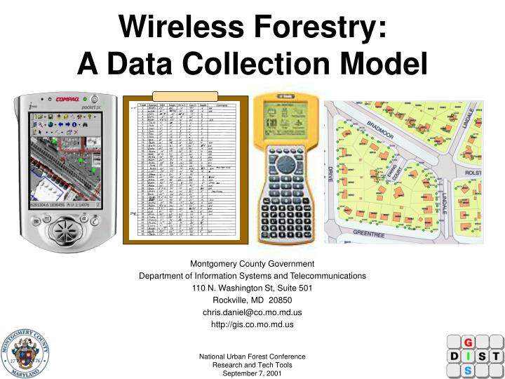
Wireless Forestry: A Data Collection Model. Presented by: Chris Daniel Montgomery County Government Department of Information Systems and Telecommunications 110 N. Washington St, Suite 501 Rockville, MD 20850 chris.daniel@co.mo.md.us http://gis.co.mo.md.us. Acknowledgements.

E N D
Wireless Forestry: A Data Collection Model Presented by: Chris Daniel Montgomery County Government Department of Information Systems and Telecommunications 110 N. Washington St, Suite 501 Rockville, MD 20850 chris.daniel@co.mo.md.us http://gis.co.mo.md.us National Urban Forest Conference Research and Tech ToolsSeptember 7, 2001
Acknowledgements • Montgomery County, MD Government • Lonnie Darr (Dept. of Environmental Protection) • Jim Himel (Forester) • Apollo Teng (GIS Manager, Dept. of Info. Systems and Telecommunications - Geographic Information Systems or DIST-GIS) • Andrew Greene (GIS Intern, DIST-GIS) • American Forests • Gary Moll (Vice President of Urban Forestry) • Ken Gorton (GIS Specialist) • United States Forest Service (Northeast Forest Exp. Station) • Dr. Wayne Zipperer • Dr. David Nowak National Urban Forest Conference Research and Tech ToolsSeptember 7, 2001
Purpose • Develop and test field survey methods for collecting and validating data using traditional data collection methods and wireless Geographic Information System (GIS) and Global Positioning System (GPS) technologies National Urban Forest Conference Research and Tech ToolsSeptember 7, 2001
Objectives • Develop a Study Plan • Obtain Approval • Implement Study Plan • Present or Publish Findings National Urban Forest Conference Research and Tech ToolsSeptember 7, 2001
Study Plan • Select the study site • Determine data collection methods • Determine method evaluation criteria • Identify data requirements • Evaluate and obtain survey equipment, hardware, and software • Hire contractor or train staff • Prepare for field survey • Conduct field survey • Perform post-processing and quality assurance • Analyze data • Present Findings National Urban Forest Conference Research and Tech ToolsSeptember 7, 2001
Study Site: Bethesda Neighborhood National Urban Forest Conference Research and Tech ToolsSeptember 7, 2001
Data Collection Methods • Traditional • Hard-copy field inventory Sheets and Maps • ArcView GIS software • Hand-held GIS • Compaq IPAQ 3670 with Windows CE Version 3.0 • ESRI’s ArcPAD 5.0.1 and ArcView GIS software • Data downloaded locally and via the Web through Internet Map Services • GPS • Trimble GPS Pathfinder Pro XR Receiver with TSC1 Data Collector • Pathfinder Office Software included • Pre-planning • Data dictionary National Urban Forest Conference Research and Tech ToolsSeptember 7, 2001
Traditional Method National Urban Forest Conference Research and Tech ToolsSeptember 7, 2001
Hand-held GIS:Compaq IPAQ with ArcPAD and Merlin Wireless Modem National Urban Forest Conference Research and Tech ToolsSeptember 7, 2001
Antenna TSC 1 Data Collector Trimble Pathfinder Pro XR GPS Pathfinder Office National Urban Forest Conference Research and Tech ToolsSeptember 7, 2001
Evaluation Criteria • Spatial Accuracy • Proximity Analysis conducted using ArcView GIS • Time • Field Preparation • Field Survey • Post-processing • Analysis • Costs • Staff • Training • Materials/Expenses • Desktop computer, Compaq IPAQ, ArcPAD & ArcView software, printer, travel,etc.. • GIS Data National Urban Forest Conference Research and Tech ToolsSeptember 7, 2001
Data Requirements • Montgomery County Department of Environmental Protection • Focus on Street Trees initially then progress to residential or privately owned trees • Tree ID #, Species, DBH, Height, Height to Crown, Crown Diameter, Health, Comments • Spatial data to be in ArcView shape file compatible format • Projection = Maryland State Plane • Datum = NAD 83 • Map units = Feet • American Forests CITYgreen Model • Tree ID #, Ownership (Public or Private), Species Code, DBH, Height to top of Tree, Reduced in Height, Health, Conflicts (overhead wires, structure, sidewalk, other trees), Ground Cover under canopy (shrubs, grass, pavement, exposed soil, mulch) • Height Class and Diameter Class were calculated • United States Forest Service Urban Forest Effects (UFORE) Model • Tree ID #, Street Tree (Y/N), Species Code, DBH, Height to top of Tree, Height to Base of Crown, Health, Crown Width, Foliage Density, Percent Dieback, # of Sides receiveing Sunlight (0 = below 5 = above canopy) National Urban Forest Conference Research and Tech ToolsSeptember 7, 2001
Equipment, Hardware, and Software • All Methods • Tree measurement tools • Measuring chain or stick, clinometer, DBH tape, or equivalent • Clipboards and pencils • Camera • Olympus Digital Camera (3 mega-pixel) • Desktop PC and printer used to create and print data sheets and maps and to run analysis or planning software • Dell Precision 330 1.5ghz with 512mb RAM with 20+ gb hard-drive • HP 2000 C color printer • ArcView GIS Software National Urban Forest Conference Research and Tech ToolsSeptember 7, 2001
Equipment, Hardware, and Software • Hand-held Computer • Compaq IPAQ 206 mhz pentium • Windows CE operating system • 16 mb ROM (Flash) …. Could expand up to at least 128 mb • 64 mb RAM • Color display (240 x 320) • ArcPAD 5.0.1 and ArcView 3.2 software • Desktop PC (Dell Precision 330 1500 mhz with 500+ Kb RAM and 20 + GB’s hard drive) with Windows 2000 • Merlin Cellular Digital Packet Data (CDPD) Wireless Modem - 19.2 kbps (Optional) • Voice recognition software (Optional) • Naturally Speaking by Dragon Systems • Voice Insight (ArcPAD 6) National Urban Forest Conference Research and Tech ToolsSeptember 7, 2001
Equipment, Hardware, and Software • Trimble Pro XR/Beacon with TSC1 GPS Unit • Backpack unit with a hand-held TSC1 data collector • Capable of Real-Time Differential GPS Corrections (DGPS) through the US Coast Guard Beacon system or a private satellite subscription service • Spatial accuracy to 50 cm • Pathfinder Office Desktop Software • Desktop PC - (Dell Precision 330 1500 mhz with 500+ Kb RAM and 20 + GB’s hard drive) with Windows 2000 National Urban Forest Conference Research and Tech ToolsSeptember 7, 2001
Hire or Train Staff • Hired a Qualified Professional Forester to assist with the tree survey • Obtained Trimble GPS training from Sam Walker Scinnovations Inc. National Urban Forest Conference Research and Tech ToolsSeptember 7, 2001
Field Survey Preparation: Traditional • Developed an inventory sheet to satisfy data requirements • Generated hard-copy maps using ArcView GIS software • Plotted street trees on maps for validation • Maps were laminated for protection • Covered clipboard used to protect data sheets • Coordinated field visits with Contractor National Urban Forest Conference Research and Tech ToolsSeptember 7, 2001
Field Survey Preparation: Hand-held GIS • Install and configure ArcPAD 5.0.1 and ArcView GIS software on Dell Precision 330 Desktop PC and Compaq IPAQ 3760 • Created a new tree file and digital inventory sheet using ArcView 3.2 and ArcView’s Dialog Designer Extension • Digital inventory sheets reduce error by enforcing field validation and incorporating pre-determined list boxes or choices specified in the data requirements • Downloaded data file, digital inventory sheet, GIS shape files (roads and street trees), and a color digital ortho-photo (one-foot pixel resolution) of the study area to Compaq IPAQ mobile mapping device with ArcPAD 5.0.1 • Set up the ArcPAD project file on the IPAQ using the downloaded data and digital inventory sheet • Incorporate voice recognition (Optional) • Voice Insight for ArcPAD 6 soon available • Configured the wireless Merlin modem and the wireless Internet service for the PDA from Verizon Wireless, Inc National Urban Forest Conference Research and Tech ToolsSeptember 7, 2001
ArcPAD Digital Inventory Sheet National Urban Forest Conference Research and Tech ToolsSeptember 7, 2001
Field Survey Preparation: GPS • Installed the Trimble Pathfinder software onto a Desktop PC and prepared the GPS unit for field work (charge batteries and check cables) • Created a Data Dictionary in accordance with the data requirements using the Pathfinder Office software and transferred it to theTSC1 data collection unit • The data dictionary reduces error by enforcing field validation and incorporating pre-determined list boxes or choices specified in the data requirements • Downloaded the latest Almanac Information from the local GPS base station (within 300 miles for sub-meter) using the Pathfinder software • Created a Mission Plan to determine the number of available GPS satellites as well as the anticipated Position Dilution of Precision (PDOP) using the Pathfinder software • PDOP is an index used by the GPS device that measures satellite geometry and predicts positional accuracy. If the PDOP is low, then the GPS satellite constellation is spread out, which yields a more accurate position. • The PDOP mask was set to 6, the number of positions mask was set to 1 position per second for 30 seconds, and the elevation mask was set to 15 degrees • A new point file was created using the GPS TSC1 Data Collector. The data dictionary was incorporated, so that each time a tree was located the surveyor could enter the attribute data required National Urban Forest Conference Research and Tech ToolsSeptember 7, 2001
Field Survey • All Methods • Street trees were inventoried initially • Consent letters, created to notify local residents for permission to inventory trees on private property, had not been delivered the survey was started • The tree location (point) and attribute information were recorded in the field • A team of at least two collected data • One person recorded the tree location, attribute information, and measured tree height while the other person conducted the other tree measurements • Photos were taken with digital cameras for presentation and web publication • Traditional Method • Tree location and identification number were recorded on a hard-copy map • Tree attribute information, including tree identification number, were recorded on a data sheet • A crew of two were able to complete about 30 to 40 trees per hour during a typical humid sub-tropical summer day (90+ degrees F with 95% humidity) National Urban Forest Conference Research and Tech ToolsSeptember 7, 2001
Field Survey: Traditional Method National Urban Forest Conference Research and Tech ToolsSeptember 7, 2001
Field Survey: Hand-held GIS • Tree location and attribute information, including tree identification number, were recorded using the Compaq IPAQ/ArcPAD 5.0.1 • The tree location was “eye-balled” using landmarks identified in the field that could be distinguished on the downloaded digital ortho-photo • The IPAQ color display screen (240 x 320) was clearly visible in the field • As a tree was added to the database, the digital inventory sheet “popped up” and enabled the operator to enter the attribute information quickly and easily • A crew of two were able to complete about 20 trees per hour during a typical humid sub-tropical summer day (90+ degrees F with 95% humidity) • One person recorded the tree location, attribute information, while the other person conducted the other tree measurements • The IPAQ’s LiPolymer battery-power lasted about 2 hours and 15 minutes. You can recharge the battery using an automobile A/C adapter. However, be careful not to plug it in when you start-up the car • The wireless data connection (19.2 kbps) from the County GIS Internet Map Server (IMS) did not work in the Study Area • When a connection was established (outside of the study area), it took about 1 minute to refresh the IMS photo (19.2kpbs) while it took < 5 seconds to bring up the photo stored on the IPAQ’s Flash ROM • The downloaded photos were used in the field to map the trees National Urban Forest Conference Research and Tech ToolsSeptember 7, 2001
Field Survey: Hand-held GIS National Urban Forest Conference Research and Tech ToolsSeptember 7, 2001
Look for Wireless Redwoods near you! National Urban Forest Conference Research and Tech ToolsSeptember 7, 2001
National Urban Forest Conference Research and Tech ToolsSeptember 7, 2001
Field Survey: GPS • Tree location and attribute information, including tree identification number, were recorded using the Trimble Pathfinder Pro XR GPS receiver and TSC1 Data Collection unit • The tree position was recorded in the GPS data receiver/logger for at least 30 seconds. This would yield sub-meter positional accuracy required • The Trimble LCD screen (240 x 200) was clearly visible in the field • As a tree position was added to the GPS database, the data dictionary “popped up” and enabled the operator to enter the attribute information quickly and easily • A crew of two were able to complete about 20 trees per hour during a typical humid sub-tropical summer day (90+ degrees F with 95% humidity) • One person recorded the tree location, attribute information, while the other person conducted the other tree measurements • Tree positions were recorded when PDOP’s < 6. When a structure or heavy tree canopy/biomass “blocked” the satellite “feed”, then the surveyor conducted an off-set. This occurred on < 10 trees measured • The GPS batteries lasted all day (at least 8 hours), provided that they are charged the night before conducting the field survey National Urban Forest Conference Research and Tech ToolsSeptember 7, 2001
Field Survey: GPS Method National Urban Forest Conference Research and Tech ToolsSeptember 7, 2001
Post-processing and Quality Assurance • Traditional Method • Attribute information from the field data sheets were entered into a Microsoft Access database • Tree points were interpolated from the maps and digitized into a GIS shape file using ArcView • Property lines, building foot-prints, and roads were used to interpolate the position of the trees • Reviewed attribute data for data entry mistakes • Spelling mistakes • Incorrect Species Codes • Examine the Comments field • Placed tree points over the digital ortho-photo using ArcView and visually reviewed the spatial accuracy to ensure that the data points were in the correct map projection National Urban Forest Conference Research and Tech ToolsSeptember 7, 2001
Post-processing and Quality Assurance • Hand-Held GIS Method • Download GIS shape file or data file to Desktop PC • Reviewed attribute table for data entry mistakes • Overlayed GIS data on digital ortho-photo and visually reviewed spatial accuracy • Wrote ArcView script to “Grow Trees” based on crown diameter for CITYgreen model • Trimble Pro XR GPS Method • Transferred data to Desktop PC • Downloaded base-station differential correction files • Performed differential correction using Pathfinder Office software • Converted to GIS shape files with the correct map projection parameters • Reviewed attribute table data entry mistakes • Overlayed GIS data on digital ortho-photo and visually review spatial accuracy • Check the off-sets National Urban Forest Conference Research and Tech ToolsSeptember 7, 2001
Analysis • Sample Size = 31 trees • Used GPS points as the Control • Conducted Proximity Analysis using ArcView 3.2 to estimate spatial accuracy of the Hand-held GIS and Traditional methods • Wrote a script to compute distances from GPS points to Hand-held GIS and Traditional method points • Calculated average, minimum, and maximum distance to each corresponding tree based on unique identifier field (Tree_id) • Recorded time and costs for each method National Urban Forest Conference Research and Tech ToolsSeptember 7, 2001
Proximity Analysis Blue= Traditional Green= Hand-held GIS Red = GPS National Urban Forest Conference Research and Tech ToolsSeptember 7, 2001
Findings: Traditional • Spatial Accuracy (Hand drawn on map and digitized) • Average = 13 feet off • Minimum = 2.5 feet off • Maximum = 50 feet off • Time • Field Preparation = 2 hours • Field Survey = 30 to 40 trees per hour for 2 hours • Post-processing = 3 hours • Data Conversion (entry) is necessary • Analysis = 1 hour • Total = 8 hours • Costs (Prices are subject to change) • Staff = $240 x 2 • Training = $0 per hour • Materials/Expenses = $4,850 • Desktop computer ($3,500), ArcView ($900), printer ($400), travel+food ($30), other ($20) • GIS Data = $425 • Total Cost = $5,755 National Urban Forest Conference Research and Tech ToolsSeptember 7, 2001
Findings: Hand-held GIS • Spatial Accuracy • Average = 7 feet off • Minimum = 2 feet off • Maximum = 22 feet off • Time • Field Preparation = 3 hours (On-the-Job-Training) • Field Survey = 20 trees per hour for 2 hours • Post-processing = 1 hour • Analysis = 1 hour • Total = 7 hours • Costs (Prices are subject to change) • Staff = $210 x 2 • Training = $0 per hour • Materials/Expenses = $5,845 • Desktop computer ($3,500), IPAQ ($500), ArcPAD ($495) & ArcView ($900) software, printer ($400), travel + food ($30), other ($20) • Wireless service ($300) + modem ($150) or IMS Server ($22,000) not included in the price • GIS Data = $425 • Total Cost = $6,690 National Urban Forest Conference Research and Tech ToolsSeptember 7, 2001
Findings: GPS • Spatial Accuracy (Used as the Control) • < 3 feet off or sub-meter accuracy after Differential Correction • Time • Field Preparation = 1 hour • Field Survey = 20 trees per hour for 2 hours • Post-processing = 1 hour • Analysis = 1 hour • Total = 5 hours • Costs (Prices are subject to change) • Staff = $150 x 2 • Training = $495 • Materials/Expenses = $15,850 • GPS Unit ($11,000), Desktop computer ($3,500), ArcView 3.2 ($900), printer ($400), travel + food($30), other ($20) • GIS Data = $425 • Total Cost = $17,070 National Urban Forest Conference Research and Tech ToolsSeptember 7, 2001
Summary • Traditional Method • Low cost solution • Spatial accuracy is generally unacceptable for County base-mapping • Need large scale field maps with planimetric data • Accuracy could be improved if tree locations were measured from landmarks in the field, however, this would slow field survey speed • Able to survey 30 to 40 trees in the field per hour • Post-processing takes time • Data entry is required • Chances of data error are higher • Requires little computer training • Most popular method National Urban Forest Conference Research and Tech ToolsSeptember 7, 2001
Summary • Hand-held GIS (Most Scalable Solution for Urban Areas) • Affordable solution for County Government • Easy to use in the Field • Portable (fits in your shirt pocket), screen resolution is acceptable • Voice recognition will be available in ArcPAD 6 through Voice Insight, Inc. • Spatial accuracy is border-line acceptable for County base-mapping • Landmarks in the field can be interpreted on the ortho-photos to enable users to place the tree point locations within 7 feet of its exact location without measuring. Accuracy could be improved if tree locations were measured from landmarks in the field, however, this would slow field survey speed • Able to survey a good average rate of trees per hour (20) • Very little post-processing required • Attribute data stored on IPAQ in the field • Reduces post-processing error • Enables access GIS data sets and ortho-photos • Data downloaded onto IPAQ Flash ROM is currently the best solution • ArcIMS Internet Map Services provide data to wireless IPAQ units and ArcPAD enables users to use the map services. Existing cellular modem technology is very slow (19.2 kbps) and you may have difficulties establishing a connection with the service provider, especially if you are in a low area. Modem technology is improving though (i.e. Ricochet, Merlin GT100). • Provides connectivity to a GPS device for navigation and mapping • Good for rural areas • Requires hand-held computer and GIS training National Urban Forest Conference Research and Tech ToolsSeptember 7, 2001
Summary • GPS • Somewhat expensive solution • If you need engineering or survey quality accuracy, this solution works great! • Spatial accuracy is excellent for County base-mapping • Minimal field preparation time • Charge batteries, check cables, create data dictionary, download Almanacs from base station, quick plan, download dictionary to TSC1 data collector and go! • Able to survey a good average rate of trees per hour (20) • Occasionally had to wait for the PDOP to drop below 6 • If you’re in a deep swale or next to large structures, you may have difficulty obtaining a good PDOP value (<6). Heavy tree canopy/biomass may also some connection difficulties • Backpack could be cumbersome for a smaller framed person • Very little post-processing required • Attribute data stored on data collector in the field • Reduces data post-processing errors • Recommend GPS and GIS Training National Urban Forest Conference Research and Tech ToolsSeptember 7, 2001
Useful Web Sites • Montgomery County GIS http://gis.co.mo.md.us • Montgomery County DEP http://www.co.mo.md.us/services/dep/ • USDA Forest Service, Urban and Community Forest Ecosystem Research http://www.fs.fed.us/ne/syracuse/ • American Forests http://www.americanforests.org • Trimble GPS http://www.trimble.com/mappinggis.html • ESRI’s ArcPAD http://www.esri.com/software/arcpad • Compaq IPAQnet Mobility Solutions http://www.compaq.com/products/wireless/wwan/index.shtml • Novatel Wireless http://www.novatelwireless.com/pcproducts/merlin.html • Verizon Wireless Service http://www.app.airtouch.com/mobile_ip/internet_access/pocketpc.html • Dragon Systems http://www.dragonsys.com(Voice Recognition) National Urban Forest Conference Research and Tech ToolsSeptember 7, 2001