Download
1 / 28
280 likes | 443 Views
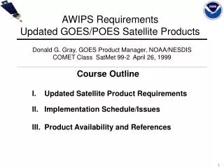
AWIPS Requirements Updated GOES/POES Satellite Products. Donald G. Gray, GOES Product Manager, NOAA/NESDIS COMET Class SatMet 99-2 April 26, 1999. Course Outline. I. Updated Satellite Product Requirements II. Implementation Schedule/Issues III. Product Availability and References.

E N D
AWIPS RequirementsUpdated GOES/POES Satellite Products Donald G. Gray, GOES Product Manager, NOAA/NESDIS COMET Class SatMet 99-2 April 26, 1999 Course Outline I. Updated Satellite Product Requirements II. Implementation Schedule/Issues III. Product Availability and References
Updated AWIPS RequirementsGOES/POES Satellite Products • GOES/POES Satellite Soundings • GOES Sounder Derived Product Images • GOES High Density Winds • Automated Precipitation Estimates • Blended Polar Sounder and Microwave Products
Updated AWIPS RequirementsGOES/POES Satellite Products(cont’d) • GOES Imager DPI • Scatterometer Ocean Surface Winds • GOES Sounder Imagery • Blended Polar Visible and Infrared Imagery • Volcanic Ash Graphics
GOES Satellite Soundings Hourly Sounder Coverage (GOES-E & GOES-W) GOES-W (Variable) GOES-W GOES-E GOES-E (Variable) Two sectors are scanned each hour by each satellite (GOES-E & GOES-W) ‘Variable’ sectors can be changed in response to significant weather events
GOES Satellite Soundings Individual Temperature/Dewpoint Profiles GOES-10 Total Precipitable Water Soundings 25 February 1999 http://orbit-net.nesdis.noaa.gov/goes/soundings/
Temperature/Moisture Soundings • Digital Sounding Files (BUFR Format) • AWIPS Workstation Applications Processor will • provide capability for display, and computation • of secondary atmospheric parameters • Course on GOES Atmospheric Soundings • Presented at AMS Conference in Phoenix, AZ, January 1998
POES Satellite Soundings 24 Hour Coverage - 2 Satellites Total Precipitable Water http://poes.nesdis.noaa.gov/posse/
POES Satellite Soundings Coverage in Polar Regions Gray: Clear Areas White/Blue: Clouds Soundings Available for Both Clear and Cloudy Conditions
POES Satellite Soundings Individual Temperature/Moisture Profile
GOES Sounder Derived Product Images (Lifted Index, TPW, Surface Temp and Cloud Top Pressure) False-color GOES-8/10 Total Precipitable Water http://cimss.ssec.wisc.edu/goes/realtime/
GOES Sounder Derived Product Images (Lifted Index, TPW, Surface Temp and Cloud Top Pressure) GOES Cloud-Top Pressure (mb) http://cimss.ssec.wisc.edu/goes/realtime/
GOES Dry Microburst Potential Index (DMPI) Likelihood of high based, low precipitation microbursts - West/Central US
GOES Microburst Day Potential Index This index is useful for showing the potential for wet microbursts in the southeast United States. An index value approaching 1 represents a high risk.
GOES High Density Winds • Winds Derived in Several Categories • Cloud-Drift IR Winds (Imager) • Water Vapor Winds (Imager) • Visible Winds (Imager) • Water Vapor Winds (Sounder) http://orbit-net.nesdis.noaa.gov/goes/winds/ Link to winds presentation
AWIPS RequirementsPrecipitation Estimates Sample Precipitation Text Product - TS Frances ZCZC NFDSPENES ALL DDHHMM;310,0980 310,0900 260,0900 260,0900; TTAA00 KNFD DDHHMM . SATELLITE PRECIPITATION ESTIMATES..DATE/TIME 9/11/98 1702Z THE SATELLITE ANALYSIS BRANCH/NESDIS---NPPU--- TEL.301-763-8678 ...EST'S FM: /GOES8-CNTRL AND E. U.S. / GOES10 - W. U.S... AUTOMATIC ESTIMATES WILL BE USED FOR A TEST PERIOD FM AUG 5 TO SEP 18. AUTO ESTS AVLBL ON RAMSDIS IN REAL-TIME..AND ON NESDIS FLASH FLOOD HOMEPAGE. LATEST DATA USED: G-8 1630Z CK . LOCATION...TX/LA . HEADLINE FOR TX...CLOUD TOPS HAVE WARMED BTWN AUS AND CRP..BUT (MORE LCLZD) HVY RAIN STILL LIKELY WITH WARMER TOPPED CELLS. COLD TOPPED CONVECTION FM BPT TO CLL ROTATES SLWY NW TO W WITH CYCLONIC FLOW..HCY RFL CONTINUES. HEADLINE FOR LA...BAND OF INTENSIFYING CNVTN DUMPS TORRENTIAL RAFL BTWN LFT AND LCH WHILE NEW TSTMS FORM SE OF MSY. . AUTOMATIC ESTIMATES... 3 HR (1330Z-1630Z) TX COUNTIES... BEE 2.4" WILSON 1.6 HARRIS 3.4 JEFFERSON/LIBERTY 2.7 LA PARISHES.. JEFFERSON DAVIS/E CAMERON/VERMILION 2.4-3.2 PLAQUEMINES/ST BERNARD 2.7 HRLY RAIN RATES ARE 1-2" (PR HR). NOTE..NO CORRECTION BOXES ARE IN EFFECT ON THE AUTOESTIMATOR. AS OF 1445Z IMAGE.. ONE CLUSTER OF TSTMS IS LOCATED BTWN SAT TO CRP HAS DECR IN CVRG AND INTENSITY OVER PAST HR. OTHER AREAS OVER HARRIS AND WALLER COUNTIES AND OVER THE JEFFERSON/CHAMBERS AND HARDIN COUNTIES..AND HAVE INCRD IN INTENSITY OVER PAST 1-2 HRS.
GOES Digital Precipitation Estimates (Automated, Gridded) Tropical Storm Frances - 9/11/98
Imager DPI - Total Precipitable WaterGOES-10 Hemispheric Coverage
GOES Sounder Radiance Imagery (False Color) • Images to be re-mapped in Lambert-Conformal Projection • Color enhancements will be required to display important • meteorological information (Unique enhancements will be • required for each of 18 infrared channels) • AWIPS sectors (CONUS, Regional, etc.) still to be defined • Examples from AMS presentation…
Implementation Schedule/Issues Prioritized AWIPS Satellite Product Requirements Completed by NWS/OM; Incorporated Into SPSRB (Satellite Products and Services Review Board) List for Resource Allocation AWIPS ‘Build 5’ is First Opportunity for Including New Products/Applications in AWIPS System - Early/Mid 2000 NWS Will Accept “Experimental” Products Pending Operational Implementation at NESDIS; ORA (Office of Research and Applications) Will Distribute Routine “Experimental” Products Many New AWIPS Products Currently Available on Internet AWIPS Applications Software Needed for Product Display and Analysis
Product Availability and References Internet • http://defiant.wrh.noaa.gov/satawips/awipapp2.htm • (AWIPS Satellite Product and Applications Requirements • http://cimss.ssec.wisc.edu • http://orbit-net.nesdis.noaa.gov/goes • http://poes.nesdis.noaa.gov/posse • http://orbit-net.nesdis.noaa.gov/ora/fpdt1/ • http://orbit-net.nesdis.noaa.gov/ • http://orbit-net.nesdis.noaa.gov/ora/ht/ff/index.html
Product Availability and References References Hayden, C.M., 1988: GOES-VAS Simultaneous Temperature and Moisture Retrieval Algorithm. J. Applied Meteorology, 27, 705-733 Menzel, W.P. and J.F.W. Purdom, 1994: Introducing GOES-I: The first of a new generation of Geostationary Operational Environmental Satellites. Bull. Amer. Meteor. Soc., 75, 377-384. Ellrod, G. P. and James P. Nelson III, 1998: Experimental Microburst Image Products Derived from GOES Sounder Data. Preprints, 16th Conf. on Weather Analysis and Forecasting, 12-16 January 1998, Phoenix, Arizona,Amer. Meteor. Soc., Boston, 43-45. Gray, Donald G., Jaime Daniels, and Gary Gray (Hughes STX), 1997: Applications of GOES Satellite Soundings in Pre-convective Environments for Severe Weather Forecasting. National Weather Association Annual Meeting, October 20-24, 1997, Reno, Nevada.
Product Availability and References References (cont’d) Ellrod, G. P and Donald G. Gray, 1997: Storm-Relative Streamlines and Other Fields Derived from GOES High Density Wind Sets, Preprints 22nd AMS Conf. On Hurricanes and Tropical Meteorology, 19-23 May 1997, Ft. Collins, Colorado, Amer. Meteor. Soc., Boston. Nelson, J. P. and G. P. Ellrod, 1997: Recent Developments in a Microburst Risk Image Product Derived from GOES I-M Satellite Sounder Data. Preprint Volume, 7th Conf. on Aviation, Range, and Aerospace Meteorology, 2-7 February 1997, Long Beach, California, Amer. Meteor. Soc., Boston, 262-267. Ellrod, G. and J. P. Nelson, 1996: Remote Sensing of Aircraft Icing Regions Using GOES Multispectral Imager Data, Preprints 15th Conf. on Weather Analysis and Forecasting, 19-23 August, 1996, Norfolk, Virginia, Amer. Meteor. Soc., Boston, 9-12. Gray, D. G., C. M. Hayden, and W. P. Menzel, 1996: Review of Quantitative Satellite Products Derived from GOES-8/9 Imager and Sounder Instrument Data. Preprints 8th Conf. on Satellite Meteorology and Oceanography, 28 January-2 February, 1996, Atlanta, Georgia, Amer. Meteor. Soc., Boston, 159-163.