Download
1 / 34
340 likes | 484 Views
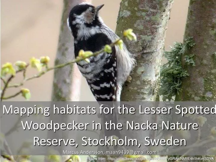
Mapping habitats for the Lesser Spotted Woodpecker in the Nacka Nature Reserve, Stockholm, Sweden Marcus Andersson, maan9439@gmail.com. Picture from: http://picasaweb.google.com/lh/photo/yGRAtcNMIlE4h1hKv8SDYA. Table of Contents. Background Aim Material Methods Result Discussion

E N D
Mapping habitats for the Lesser Spotted Woodpecker in the Nacka Nature Reserve, Stockholm, SwedenMarcus Andersson, maan9439@gmail.com Picture from: http://picasaweb.google.com/lh/photo/yGRAtcNMIlE4h1hKv8SDYA
Table of Contents • Background • Aim • Material • Methods • Result • Discussion • References
Background • Lesser Spotted Woodpecker(LSW) Umbrella species • High demands • Dead Wood • Moist Forest • Decidous Forest • High crown coverage (dense forest)
Background • Habitat size Maximum 200 Ha with minimum 40 Ha of decidous forest • OR 40 Ha habitat with minimum 20% decidous in the habitat (during early spring) • Proxys for dead wood Old forest, high moisture
Aim • How are the potential habitats for the LSW in the Nacka Nature Reserve distributed? • In extention: Where is the old, wet, decidous forest with standing dead wood and high crown coverage? • These criterions are then supposed to imply a good and healthy forest which supports a wide range of other animals demanding one, or more, of the same criterions
Material • Orthophoto over the area • Field notes and GPS-points • Terrängkartan
Terrain map overlaying the original classification and the orthophoto
Method • Literature studies Habitat demands • Remote sensing, using orthophotos viewed in stereo • Digitizing areas of interest (and others…) according to the criterions: General landcover, forest type, moisture gradient (amount of dead wood and age)
Method • Select ”core habitats” for the LSW • Make buffer zones around the core habitats • Calculate these zones according to the habitat demands • Present the results (Maps & statistics)
Method Flow Chart in Model Builder
This is the original classification shown with the attributes ”Vegetation class” and ”Moisture”. SQL: Select from ”original” where ”Vegetation” = Forest AND (”Moisture”= ”Mesic to Moist” AND ”Moist to Wet”)
This is the original classification shown with the attributes ”Vegetation class”, ”Moisture” and ”Crown Coverage”. SQL: Select from ”original” where ”Vegetation” = Decidous forest AND (”Moisture”= ”Mesic to Moist” AND ”Moist to Wet”) AND (Crown Coverage = >70%)
This is the buffered zones around the optimal habitats. Buffer with 356,9 meter radius. (The radius of a circle with the area 40 Hectars) Some strech outside the border
This is the buffered zones around the optimal habitats, buffered with 356,9 meter radius (The radius of a circle with the area 40 Hectars), and clipped against the boarder
This is the original classification shown with the attribute ”Decidous forest” in ”Vegetation class” and the bufferzones are now clipped against the boarder and the ones <40000m2 are removed
This is the result of where ”buffer” intersects ”Original veg map”. 3728 polygons with attributes
Excel calculations of how much decidous forest each of the buffered core habitats include
Excel calculations of how much decidous forest each of the buffered core habitats include
Excel ArcGIS Select From Where ”Percentage <=20” Manual Editing (Add percentages to Attribute Table)
Results • Maps • Statistics • Maps showing statistics
This is the original classification shown with the attribute ”Vegetation class”. • Contains 615 polygons • Classification scheme (as in the legend): • Open water incl floating vegetation • Hard areas • Open grounds • Non forested bedrock outcrops • Coniferous >50% coniferous • Hällmarkstallskog (Pine on thin soil) • Mixed decidous >50% decidous • Broadleaved forest >50% broadleaved • Trivial decidous forest >50% trivial • Mixed decidous/coniferous forest
All the potential habitats that are larger than 40 Hectars and contain at least 20% decidous forest. Also showing the decidous forest that lays outside any potential habitat.
All the potential habitats that are larger than 40 Hectars and contains at least 20% decidous forest. Shown with different colours indicating different percentages of decidous forest within the different potential habitats
The overlaps of all the potential habitats that are larger than 40 Hectars and contain at least 20% decidous forest. Shown with different colours indicating how many habitat is overlapping another. ”Hot-Spots”
Discussion • Overlapping habitats = Not good. Different potential habitats ”share” the same patches of decidous trees. Can probably be solved with the existing datasets though. • The use of high moisture as the only indicator for dead wood. Hard to see dead wood in orthophotos. Tried to locate old maps showing when an area was abandoned, no success due to time limits.
References • Indicator species among resident forest birds – A cross-regional evaluation in northern Europe.Jean-Michel Roberge, Per Angelstam. Biological Conservation 130 (2006) p. 134 – 147. • Faktablad: Dendrocopos minor – mindre hackspett. ArtDatabanken 2006-05-29. Börje Pettersson 1987. Rev. Sven G. Nilsson 1995, 2001 & 2006. • Scale issues in the assessment of ecological impacts using a GIS-based habitat model — A case study for the Stockholm region. Mikael Gontier. Environmental Impact Assessment Review 27 (2007) 440–459 • Seasonal variation in home-range size, and habitat area requirement of the lesser spotted woodpecker(Dendrocopos minor) in southern Sweden. Ulf Wiktander, Ola Olsson, Sven G. Nilsson. Biological Conservation 100 (2001) 387–395 • Direct and indirect weather impacts on spring populations of lesser spotted woodpecker (Dendrocopos minor) in Norway. Vidar Selås, Ronny Steen, Sverre Kobro, Terje Lislevand, Ingvar Stenberg. Scandinavian Journal of Forest Research, 23: 2, 148 – 153 • Mikusinski, Grzegorz. Woodpeckers: distribution, conservation, and research in a global perspective. Ann. Zool. Fennici 43: 86-95 • Specialised woodpeckers and naturalness in hemiboreal forests – Deriving quantitative targets for conservation planning. Jean-Michel Robergea, Per Angelstam, Marc-Andre´ Villard. Biological Conservation 141 (2008) 997 – 1012. • Why study woodpeckers? The significance of woodpeckers in forest ecosystems. Raimo Virkkala. Ann. Zool. Fennici 43: 82 – 85 • Habitat thresholds for focal species at multiple scales and forest biodiversity conservation – dead wood as an example. Angelstam, P. K., Bütler, R., Lazdinis, M., Mikusinski, G. & Roberge, J.-M. 2003. Ann. Zool. Fennici 40: 473 – 482 • Woodpeckers as Indicators of Forest Bird Diversity GrzegorzMikusinski, Maciej Gromadzki and Przemyslaw Chylarecki. Conservation Biology, Pages 208–217 Volume 15, No. 1, February 2001