Download
1 / 18
180 likes | 194 Views
Join us for a joint coaching day on March 10th, 2013, hosted by the CSC and DHPC clubs. This interactive day will cover the essentials of cross country flying, including mental and physical preparation, reading the weather, selecting the best site, equipment, planning, flying strategies, emergencies, and improvement strategies. Don't miss out on this opportunity to enhance your cross country flying skills!

E N D
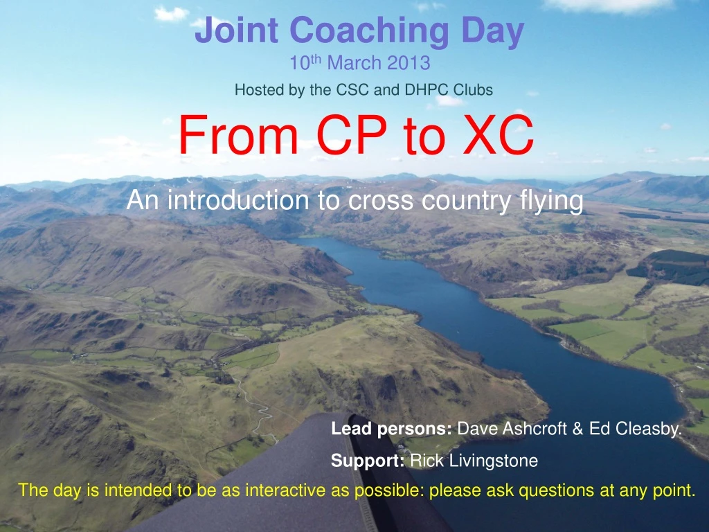
From CP to XC An introduction to cross country flying Joint Coaching Day10th March 2013 Hosted by the CSC and DHPC Clubs Lead persons: Dave Ashcroft & Ed Cleasby. Support: Rick Livingstone The day is intended to be as interactive as possible: please ask questions at any point.
Programme (approx) • Start - 10:00: Welcome, Introduction and programme for the day • RL - 10:10: Group profile • The day will break down into approximately 4 x 1 hr slots with shorts breaks around 11:30, 12:45 – 1:30 lunch, 2:45 and finishing 4pm • The bulk of the day will be jointly covered by DA/EC and will focus on the following areas: • Why fly XC? • When are you ready for XC? Discussion topics • Mental blocks/concerns to going XC? Going XC – the essentials a) Mental and physical preparation b) Reading the weather – identifying the good days c) Selecting the best site – Dales/Lakes/Pennines d) Equipment – instruments, radios, cameras e) Planning and general flying skills/strategies f) When to leave the hill g) Choosing best lines/on glide – speed to fly h) Finding the next thermal -observational skills i) Reading and using clouds/terrain – third’s rule j) Changing gear • k) Effects of wind and sun • Making effective use of Instruments • Airspace considerations • Planning your landing out – when/where • Judging terrain, slope and wind direction • Getting back! • Post flight reflection • Using flight information – tracklog/photos • Improvement strategies • q) Emergencies – use of 112/SPOT • PLENARY
Mental preparation • Focused, avoid distractions • Positive frame of mind • Mental rehearsal of flight • Arrangements sorted • Relaxed Physical preparation • Toilet break • Fluids • Food • Clothing (dress for altitude) • Charged batteries • All equipment checked • a) maps • b) phones • c) money/cards • d) hitching signs
Reading the weather – identifying the good days • A good day has: • A good clean air mass , often post frontal • Winds between 8 – 15mph and fairly constant with height • A decent cloudbase, at least 4000’ + (5500’ to 6500’ is good in the UK) • Limited over-development and not too unstable • No strong inversion that is reluctant to lift or break • Plenty of sun on the ground
Selecting the best site • Known good thermal/xc site • Stress-free terrain downwind • Proven thermal course/respite ridges • Easy start early in flight • Likely to have company • Free of major restrictions • Plenty of good landing options • Mobile signal down route
Instruments • Flight information – fields(?) • Navigation • Communication • Fairly straightforward to use • Capable of producing 3D tracklog • Good battery life • Visual recording • a) stills/HD movie – Go Pro/Muvi/Drift etc
Flight planning and general flying skills/strategies • Pre-flight route planning • Reduce in-flight workload • Study maps/know the terrain • Some idea of line and likely thermal • sources and triggers • Retrieval and arrangements made • Hazard areas • Know landing out areas • General flying skills/strategies • Where/when to take off • Searching for the climb out • Working with others • Thermalling with others • Observational skills • Re-locating a lost climb
When to leave the hill? • Get a feel for the day first • Mentally comfortable • In a solid climb • The sky downwind • A reasonable cloudbase • The amount of sun on the ground downwind • A good size quality/gaggle • Listen to radio chatter • Beware! gaggle with good pilots will leave you behind after • only the second thermal
Choosing the best lines – on glide/speed to fly • On glide - search formation – spread out, line abreast • Compare your line with others • Line up several cloud/ground sources • Resist bar unless in heavy sink/racing • Glide more important than speed – know your polar curve
Find the next thermal – observational skills • Reading terrain – albedo values • Thermal sources • Thermal triggers • Reading clouds • Stages of development • Using cloud shadows for sky map • Cautionary note • The power of good observational skills • birds, smoke, water patterns, other gliders, cloud shadows, crops sun, etc
Reading clouds/terrain • Reading clouds (using clouds in the middle/top third) • Visual indicator of atmospheric conditions – airmass, humidity, thermal heating, fronts, etc • Infinite sizes, shapes, strengths – to non-visible (blue thermals) • The ‘classic’ cumulus provide excellent stepping stones to progress (thermal mapping) • Using cloud shadows • Assessing clouds in terms of thermal strength/remaining life/safety • Cloudbase heights – changes over time • Thermal strength – changes over time • Avoiding going into cloud - actions “What goes up must come down …….”
Reading terrain • Reading terrain (using ground sources in the middle/bottom third) • Thermal heating differences – albedo values – strong contrasts between areas • Different ground sources at different times of the day • Trigger points and lines • Visual indicators of thermal release • Entrainment – charcteristics of low level thermals “Your speed is dictated less by the glider, than by the conditions or as the day changes”
Wind and sun effects • Corollas effect – to veer with height • Cloud streeting • Bending of thermals with height • Effects of sun on valley and adjacent high ground Wensleydale
Making effective use of instruments • Useful fields of information • FLIGHT INFO’ • Vario – visual/audio? • Ground speed • Height QNF – QNH • Glide angle • Time • Wind speed and direction • Your bearing • NAVIGATION INFO’ • Your location • Your track • Airspace • Distances TO(?) goal or TP • GPS enabled and recording a tracklog.
Airspace considerations • buy/study an airspace map • Carry it to be legal • Load airspace onto your GPS • Set GPS mapping to only what • you need – avoid extraneous detail • Know your area • Pre-plan route to avoid airspace • Plan well in advance to avoid airspace • If you fly in some areas then airspace is • a big issue in your route planning and • en-route navigation. • The Lakes has little below FL65 but it • does have some and some D areas. • The Dales is not too bad, but once you • enter the Vale of York it can get more • complex. It depends on the direction you take and the distance from take off.
Planning your landing out • Approaches • Don’t push it – or leave it too late • When getting low (below 1000’) give some thought to landing options • Map out the various obstacles/hazards – power lines, masts, fences, trees etc • Plan your approach to go over last ditch, thermal sources • Assess wind direction – your instruments plus ground indicators. • Check that upwind of your chosen field there aren’t rotor hazards if windy • Fine tune your landing options as you get lower – have a plan B and C • Avoid crops, stock – especially horses • Try to make it near a road, village and check the gate location on finals. • After landing • Bundle glider move to side of field • Be courteous if approached • Check mobile signal - pack, eat/drink – look at map • Plan your retrieve – carry a hitching sign • Get to know/ask – bus/train timetables • Co-ordinate with others
Post flight reflection and analysis • After any xc it’s normally to try to re-live the • excitement of the flight and think about • where you made mistakes or things you • could have done better. • Having photos/video and tracklogs makes • Much easier. • Capture still photos of key decision points • Download and study the tracklog in terms • of • a) the lines you took • b) your thermalling techniques • c) comparing your line against others if • possible • d) the key decision points • e) where thermals were to be found. • What you could learn from your mistakes • – be honest. • What could you do to fly better/further? • Technique, efficiency, composure, equipment, • Knowledge, with others, etc. SET GOALS
Other stuff SIV/pilotage Emergency equipment Volbiv Study books/videos Courses