Download
1 / 67
670 likes | 820 Views
Partnerships. Vertical Integration Efforts in Ohio. Stu Davis, Administrator Enterprise Shared Services Service Delivery Division Office of Information Technology. 2005 Ohio GIS. Lessons Learned. Currency Is Imperative - Worth building, worth maintaining

E N D
Partnerships Vertical Integration Efforts in Ohio Stu Davis, Administrator Enterprise Shared Services Service Delivery Division Office of Information Technology 2005 Ohio GIS
Lessons Learned • Currency Is Imperative - Worth building, worth maintaining • Accuracy Is Crucial - Must support all levels of government • Interoperability – Datasets built on common spatial framework • Cooperative efforts for data acquisition, development and sharing Integration and Collaboration - Only way to prepare for Ohio’s future
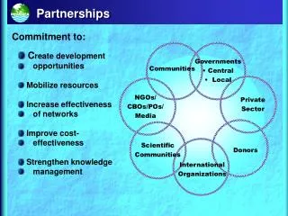
OGRIP Ohio Geographically Referenced Information Program • The authorized GIS coordinating body for State and local government GIS activity • Communicate geographic activities • Promote cooperative efforts for data acquisition, development and data sharing • Coordinate geographic information resources • Foster education/awareness of GIS
The World According to Stu: What is Vertical Integration? The ability to create or develop “anything” that meets a common need and supports multiple levels of government. Vertically integrated entities – levels of government are united through a hierarchy and we share a common interest in the data. Each member of the hierarchy may produce a different product, and the products combine to satisfy a common need or objective.
Coarse Detail Federal Level Apps Programs Regional multi-state Minimum Attributes Low Resolution Least $$ State Level Apps State & Federal Programs Multi-County Multi-State Less Attributes Lower Resolution More $$$ Local Level Apps Serve People Multi-Neighborhood More Attributes Higher Resolution Most (BIG) $$$$ Less detailed data Integrat ion More detailed data
Benefits of Vertical Integration Geographic Data Sharing • more effective use of dollars • develop applications faster • improve customer satisfaction • provide better decision-making • utilize data produced by others • extend analysis beyond jurisdictions • resolve problems created by conflicting data • redirect resources associated with duplication • reduce dissemination costs by direct access • provide a foundation for others to build upon Internal GIS Use
Collect it once - use it a bunch …. and maintain it • Develop solid GIS foundation • Sustained and maintained foundation • Interoperability - Other organizations use foundation for their specific applications • Create Ohio enterprise-wide perspective a community resource
Vertical Integration Issues and Challenges • Time and Money • Funding - Leveraging State, Local and Federal Dollars for Ohio • Framework for interaction and partnerships – MOAs, MOUs • Communication and cooperation across Jurisdictional Boundaries • Creation of an Ohio Enterprise-wide Perspective - Viewing issues regionally • Lack of consistent standards, multiple formats, different methods of development • Maintenance skill sets • Data access and distribution – Ownership and Privacy Issues, Where and how do we store it…restrictions on data, etc. • Equitable means of supporting local government participation • Implementing and Maintaining a Comprehensive GIS Program for Ohio
Stu’s Five Rules of Vertical Integration Stu’s 1st Rule – Identify stakeholders and interested parties and define relationship to the data – there must be identifiable benefits to all stakeholders Stu’s 2nd Rule – Determine who has a vested interest in the data – its currency, quality and accuracy Stu’s 3rd Rule – Determine maintenance responsibilities Stu’s 4th Rule – Create a dialog between stakeholders to establish roles, responsibilities and expectations for collaborative efforts Stu’s 5th Rule – Develop a framework for working together - PARTNERSHIPS
OGRIP Forum • FRAMEWORK DATA TASKFORCES
OGRIP’s GIS Framework Concept Build Once, Use Many Times Demographics Flood Zones Land Ownership Landcover Transportation Hydrography – Surface Waters Cultural Boundaries Water Lines Geodetic Control/Elevation Sewer Lines Soils Digital Imagery Ohio’s Framework Data Other Thematic Data
http://das.ohio.gov/itsd/ess/Ogrip/countyprofiles.htm OHIOCOUNTYGIS
For the purpose of a Statewide Spatial Data Portal OHIOCOUNTYGIS
Importance of Profiles • Provides a snapshot of GIS activities across the state • Support the potential for collaborative programs • This allows us to identify commonality and build business cases for obtaining funding to support vertical integration projects. • The completion of the County Profiles will be tied to obtaining state funding through OGRIP
Locating information by Address • Inconsistent Addressing information • Too many standards to choose from? • Everyone and their brother can assign addresses • No central authority • No clear maintenance responsibilities • Confidence and reliability w/results vary greatly • Legacy addressing databases
ZIP Code is not granular enough Address Based ZIP+
k SR-103 Un-Posted Addresses Interpolated 18955 SR-103 SR-103 SR-103 Field Verified 18955 SR-103 OGRIP/GISSC
Location Based Response System (LBRS) • Statewide high resolution road centerline coverage • Address ranges and site specific address • Higher confidence/increase reliability for geocoding • Known accuracy – understanding limits of data and use • Partnership with local government – not data grab! • Memorandums of Agreement (MOAs) • Integration of state and local government databases • Updated and Maintained • In a nutshell….One set of geography - Multiple attributes for different uses at all levels of government A new and better way of doing business
Positional Accuracy–1994 Image & 1998 Data Source OGRIP/GISSC
LBRS Goal and Objectives Goal – to create a comprehensive, consistent, accurate and maintained multi-jurisdictional statewide asset Asset for Ohio - a street centerline with site-specific addresses and address ranges to ensure the quick and rapid response of emergency responders to natural and man made disasters. Objectives • Sustainable partnership between state and local government • Establishment of countywide GIS committee • Establishment of a countywide LBRS sub-system • Establishment of a county model for QA/QC of data • Development of LBRS maintenance and update procedures • Development of extract/upload of data to the GIServeOhio
LBRS Criteria • Existing GIS Activity – centerline and address development • Existence of County GIS team • Commitment to technology • Commitment to a sustainable partnership • Multi-Agency participation • Auditor, Commissioners, Engineer, Sheriff • Health Director, EMA Director, E-911 Coordinator • Dedicated project manager • Cooperation with E-911 • MOA - stipulations • Review/acceptance of proposed scope/data specification
Cost & Funding • Total Estimated Cost - $14.6 million • Total Capital Fund Request – $ 7 million • $1.5 million in FY03/04 capital funds – Approved • $1.75 million in FY05/06 capital funds – Approved • Cost share – State/Local • Equitable distribution of dollars • Haves & have-nots • Other Funding possibilities • Reallocation of state dollars • Federal Support • Grants • Homeland Security • Public Safety
Ohio’s LBRS The foundation for: • Data sharing at all levels of government • Developing interoperable data sets • Defining new mechanisms for collaboration • Creating enhanced data sets for Ohio Vertical Integration Partnerships
Ohio’s Imagery Task Force developed a Statewide Imagery Strategy Strategy looked at a variety of Solutions • Satellite Imagery Solutions • Digital Camera Solutions • Traditional Digital Imagery Solutions • Spec Flight Solutions • Existing Imagery and requirements • Local Government • State Government • Developed a Plan
Mapping/Engineering Change Detection Land Use/Land Cover Inventory Analysis Public Safety Land/Resource Management Assessment Emergency Response Referential Data Digital Imagery Sources Imagery supports numerous applications • Resolution – 30 meter to 3 Inch Pixels • Geo-referenced – positional accuracy • Currency – dependent upon use
Resolution Examples 10 meter SPOT 1 meter DOQQ
Resolution Examples 1 meter DOQQs 1 ft Digital Orthophoto
State and Local Imagery Pros • Exists and available – Local and State • Higher resolution – Local • Currency – statewide coverage is at least 10 years old • LiDAR provides a solid foundation for imagery solutions • LiDAR support numerous GIS applications Cons • Various sources and accuracies – lack of consistency - Local • Currency issues/scheduled reflys – Local and State • Various solutions used – Local • No current sustainable funding source – Local and State
Statewide Imagery Program Statewide Imagery Program Solution • Develop a sustainable statewide imagery program for Ohio • Develop a deliverable based specification that supports state and local government requirements • Ensure QA/QC and Acceptance program is in place • Garner multiple State Agency and Federal support (funding) Imagery Provisioning through GIServOhio • Gather existing county imagery • Acquire US Agriculture’s NAIP Photography • MOU with Counties with clearly defined access and distribution restrictions • Create a Imagery Repository – discovery, access and distribution of Imagery