Download
1 / 41
410 likes | 528 Views
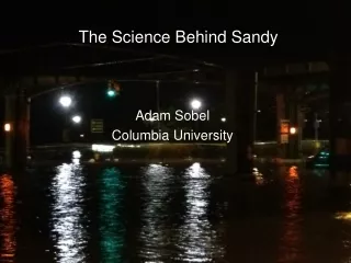
The Science Behind Sandy. Adam Sobel Columbia University. Biography of a hurricane. 30. 29. numbers are dates in October. 28. 27. 26. Yellow = tropical storm Red = cat 1 hurricane Magenta = cat 2. 25. 24. Blake et al. (2013) NHC report on Sandy. 23. 22. nytimes.com.

E N D
The Science Behind Sandy Adam Sobel Columbia University
Biography of a hurricane 30 29 numbers are dates in October 28 27 26 Yellow = tropical storm Red = cat 1 hurricane Magenta = cat 2 25 24 Blake et al. (2013) NHC report on Sandy 23 22 nytimes.com
Sandy’s grandparents:The Madden-Julian oscillationand the North Atlantic oscillation
The Madden-Julian oscillation – a natural fluctuation of the tropical climate Outgoing longwave radiation 15S-15N Blue = rainy Orange = clear Aug 2011 Sep Oct Nov time-> Dec Jan longitude Source: Matt Wheeler, Centre for Australian Climate and Weather Research cawcr.gov.au
The Madden-Julian oscillation – a natural fluctuation of the tropical climate Outgoing longwave radiation 15S-15N Blue = rainy Orange = clear Aug 2011 Sep Oct Nov time-> Dec Jan longitude Source: Matt Wheeler, Centre for Australian Climate and Weather Research cawcr.gov.au
The Madden-Julian oscillation – a natural fluctuation of the tropical climate Outgoing longwave radiation 15S-15N Blue = rainy Orange = clear Aug 2011 Sep Oct Nov time-> Dec Jan longitude Source: Matt Wheeler, Centre for Australian Climate and Weather Research cawcr.gov.au
The Madden-Julian oscillation – a natural fluctuation of the tropical climate Outgoing longwave radiation 15S-15N Blue = rainy Orange = clear Aug 2011 Sep Oct Nov time-> Dec Jan longitude Source: Matt Wheeler, Centre for Australian Climate and Weather Research cawcr.gov.au
Sandy formed as an active MJO passed through the north Atlantic basin – so it had Pacific ancestry Blake et al. (2013), NHC report on Sandy
The other player was the North Atlantic Oscillation, natural fluctuation of the high-latitude jet stream - - + - source: ldeo.columbia.edu
The other player was the North Atlantic Oscillation, natural fluctuation of the high-latitude jet stream - - + Jet stream shifted south, cold in eastern US source: ldeo.columbia.edu
In mid-October the NAO was heading into strongly negative territory, conducive to cold-air outbreaks in eastern US - + Source: NOAA CPC, www.cpc.ncep.noaa.gov
And on Oct. 20, 2012, blocking high (typical of negative NAO) moves into the western north Atlantic 500 hPa geopotential height
And on Oct. 20, 2012, blocking high moves into the western north Atlantic 500 hPa geopotential height Jet sream H
Oct. 22, 2012, NHC names Tropical Depression 18, then a few hours later upgrades to Tropical Storm Sandy GOES visible satellite image 10/22 at 15 UTC http://rammb.cira.colostate.edu/
Wed. 10/24 – landfall in Jamaica (cat 1) Cuba next day 10/25 (cat 3)
Deterministic GFS 6-day forecast for Monday night 10/29, made Wed. 10/24
Deterministic ECMWF 6-day forecast for Monday night 10/29, made Wed. 10/24
Interaction with extratropical system, Fujiwhara effect, landfall
Interaction with extratropical system, Fujiwhara effect, landfall
Visible MODIS satellite image from Saturday, 10/28 http://www.wunderground.com/blog/JeffMasters/
Animation from GFS forecast, images by Kyle Griffin, U. Wisc. PhD student
Sandy near landfall was declared “post-tropical” – note high asymmetry (false color IR)
Sandy near landfall was declared “post-tropical” – note high asymmetry (false color IR) Because of this, no hurricane warnings were issued north of NC, causing some confusion…
NYC storm surge • Landfall in Jersey at sharp angle moving westward • Winds are stronger to right of track • Onshore winds • Very large wind field • Worst possible situation
Historic Hurricane landfalls in NY/NJ Figure by Tim Hall, NASA GISS 1903 Donna (1960) Sandy Irene 1893 1938
Synthetic track model says NJ landfall at cat 1+ at Sandy’s angle is a 700 yr event. Flood return time is probably shorter. Not accounting for climate change. synthetic storms 1903 “vagabond” Sandy T. Hall and A. H. Sobel, Geophys. Res. Lett., in press.
Storm tide at Battery highest ever recorded by tide gauge (since 1920); 1821 may have had larger storm surge Sandy Scileppi and Donnelly, 2007, Geochem. Geophys. Geosys.
Our latest and best models give a mixed predictions about how the number of hurricanes will change in a warming climate Fractional change In number of N. Atlantic Hurricanes Different climate models Zhao et al. (2009) Journal of Climate
But we do have some confidence that the most intense storms will become stronger still Dan Shaevitz, Suzana Camargo, US CLIVAR Hurricane Working Group, NOAA/GFDL model
But we do have some confidence that the most intense storms will become stronger still Dan Shaevitz, Suzana Camargo, US CLIVAR Hurricane Working Group, NOAA/GFDL model
But Sandy was not so intense (cat 1) at landfall… the large surge was due to: • Its huge size, due to extratropical transition – we know • nothing about what warming will do to that; • Its track – we know little about what warming will do to that, • but…
Distorted jet, a la Sandy, has been associated with polar amplified global warming (Francis and Vavrus 2012)… But climate models give the opposite result (E. Barnes, L. Polvani, AHS)
The really clear and simple link to climate is via sea level rise. 1 meter Nicholls and Cazenave, 2010, Science
With 1m sea level rise, depending on projections of TC change, can get increase of ~2-20 in flood frequency. (i.e. 20 means 100-year flood becomes 5-year) Lin et al. 2012, Nature Climate Change2, 462-467.
With 1m sea level rise, depending on projections of TC change, can get increase of ~2-20 in flood frequency. (i.e. 20 means 100-year flood becomes 5-year) Lin et al. 2012, Nature Climate Change2, 462-467.
With 1m sea level rise, depending on projections of TC change, can get increase of ~2-20 in flood frequency. (i.e. 20 means 100-year flood becomes 5-year) With this model, 1000-year flood becomes 70-year Lin et al. 2012, Nature Climate Change2, 462-467.
GFS Ensemble run Wednesday 10/24 – same model, 20 slightly different initial conditions