Download
1 / 55
550 likes | 804 Views
Enrichment of the MedWet Inventory Method Exploring applications of Remote Sensing techniques and of Spatial Data Infrastructure. Corine Land Cover and Land & Ecosystem Accounting tools. Jean-Louis Weber European Environment Agency. Preamble: a new EEA report to come.

E N D
Enrichment of the MedWet Inventory Method Exploring applications of Remote Sensing techniques and of Spatial Data Infrastructure Corine Land Cover and Land & Ecosystem Accounting tools Jean-Louis Weber European Environment Agency
Preamble: a new EEA report to come... An integrated assessment of issues such as...
...coastal erosion... Map 12 Coastal erosion patterns in the European coasts (2004)
...pressure on the coast (urban, agriculture) Map 3 Share of built-up area in the 0–1 km coastal strip, by NUTS 3 (2000)
...nature protection which is mostly concentrated on the 1st km of coast... Figure 11 Distribution of NATURA 2000 sites in coastal zone by 1 km bands from the coastline and in the marine 10 km zone (blue) Source: ETC-TE and ETC-BD/ EEA. 2005, based on Natura2000 database
...change in land cover... Figure 1 Land cover change in 19 of the coastal European countries (1990–2000) 10 km coastal zone
...urban land take and increase are more important in the 1st km Figure 4 Change of built-up areas in 0–10 km and 0–1 km coastal zones Source: ETC-TE
...and assessment of the ecosystems potentially impacted Map 5 Wetland concentration in Europe (2000) Source: ETC-TE / EEA. 2005
CLC and land & ecosystem accounts: Outline • Corine land cover 1990 & 2000: main sources for assessing land cover state and changes resulting from land use • Land accounting as the tool for systematic assessments • Land accounts as an infrastructure for developping ecosystem accounts • and a tour of Mediterranean wetlands...
CLC: 1 nomenclature for 34 countries (of which 23 completed for 2 dates, 31 for 1 date and 2005 in preparation)
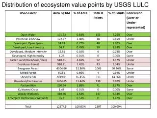
Wetlands in Corine land cover • NB: • Rice fields can be isolated as well and added to the list above • CLC maps landscape units > 25 ha and broder than 100 m small wetlands can be found in other CLC classes, in particular in mosaics of agricuture and nature
1990 2000 Accounting with Corine land cover 1990-2000
Land cover accounts are produced for 1 km² grid cells K1000 E3666 N2073 2 14 71 7 6 Total surface: 100 Ha Each grid cell is given attributes: Country, administrative region, river basin, coastal zone/hinterland, bio-geographical region, river basin, landscape type. It facilitates queries and reporting
Land cover change accounts: from maps to statistics Land cover 1990 & 2000 and land cover change are first converted to a grid (below, 3x3 km) LCF1 Urban land management LCF2 Urban residential sprawl LCF3 Sprawl of economic sites and infrastructures LCF4 Agriculture internal conversions LCF5 Conversion from other land cover to agriculture LCF6 Withdrawal of farming LCF7 Forests creation and management LCF8 Water bodies creation and management LCF9 Changes due to natural & multiple causes Individual changes are grouped by land cover flows that describe processes
And back to maps, e.g. land uptake by artificial development, NUTS2/3, deviation of the European average, mean annual values ESPON HYPERATLAS - MULTISCALAR TERRITORIAL ANALYSIS
Wetlands e.g. Urban sprawl in the province of Venice, 1990-2000, cells of 1 km x 1 km – wetlands in the background Despite possible threats from sea level rise and the permanent ecological problems of the lagoon due to agriculture eutrophicating surpluses, urban and infrastructures development has continued in the province of Venice.
Production & Consumption Land use economic & social functions Ecosystem services Atmosphere/ Climate Ecosystem potentials Water system Artificiality of land Integrity, health & viability Infrastructures & Technologies Intensity of use Vulnerability Natural Assets Population LAND USE ACCOUNTS ECOSYSTEM ACCOUNTS CORE LAND COVER ACCOUNT Flora & Fauna Soil Land based ecosystem accounting
Accounting for ecosystems: 5 questions • How many, how much? (land cover units, small ecosystems, rivers, biomass, water...) • In which state/health? (¤ homeostasis ¤ resilience ¤ modification process with no return ¤ collapsus) • Which supply of goods and services? (availability and use) • What are the stresses and stressors? (the responsible sectors) • Wealth and other values, the Natural Capital
Ecosystem health: counts of diversity/integrity • Ecosystem Distress Syndrome model: • Disruptions of nutrients cycling (loss or excess) • Degradation of substrates (fragmentation, water stress, chemical stress) • Change in species composition (invasive…) • General approach • Systematic check up • At any scales • For any habitat types • Specific diagnosis Selection of markers and threshold values according to: • Habitat types (detailed) • Region, Context • Focussed research of stressors • Overharvesting • land/rivers restructuring • deposition of residuals • introduction of species Can be enlarged to: • Sustainability of systems (without subsidies, energy input…) • Ability to support healthy population
Framework of Ecosystem and Natural Capital Accounts Spatial integration Economic sectors Ecosystem Stocks & State Accounts Natural Capital Accounts Basic stocks/flows accounts Material flows & ecosystem services (including land cover accounts) Ecosystem types Supply & use of ecosystem goods and services Counts of integrity/diversity & ecosystem state Natural assets accounts Economic integration
Ecosystem services Ref to Millennium Ecosystem Assessment:
(courtesy Danube Delta National Institute) Wetlands accounts application: individual systems and statistical approach WETLANDS 1990 OF N-W EUROPE EEA/ETCTE
Fires Droughts (SPOT4-Vegetation/ CNES – Vito) Vegetation productivity, seasonal change (MERIS/JRC-IES) Forest structure (MODIS-Multi-angle/JRC-IES) Texture, parcelisation changes 1988 – 1998 (Landsat/JRC-IES) Integration of space monitoring into ecosystem accounting: land cover change x NPP x structure/texture x short time variability x stratification of in situ monitoring (biodiversity, water…)
T T+10 1/500 000 (LC main trends, Vegetation & Humidity + Pan-European, Global …) 1/100 000 Corine Land Cover (EU/Countries, Regions, Basins, Ecological corridors) 1/10 to 25 000 (Cities, Natura2000 sites, coastal zones, risk areas) Fauna, Flora, Physico-Chemical parameters Fauna, Flora, Physico-Chemical parameters Socio- Economic Statistics Socio- Economic Statistics In situ monitoring Integrated land cover, land use and ecosystem monitoring & accounting – a nested approach
... a tour of Mediterranean wetlands, as seen by land accounting and spatial analysis of CLC data